Search
Search Results
-
Characterization of pyrolytic properties of pyrite in the terahertz frequency band
A systematic terahertz spectroscopy study of the mineral phase transformation process of natural pyrite samples heated in a nitrogen atmosphere is...
-
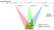
Frequency design of LEO-based navigation augmentation signals for dual-band ionospheric-free ambiguity resolution
Due to the spectrum congestion of current navigation signals in the L-band, it is difficult to apply for another two proper frequencies in this band...

-
Gravity field modeling in mountainous areas based on band-limited SRBFs
In this study, a novel two-scale spherical radial basis function (SRBF) modeling method is proposed for regional gravity field determination. First,...

-
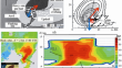
Characterization of multi-band GNSS multipath in urban canyons using the 3D ray-tracing method
The multipath effect is the major challenge that deteriorates the high precision and robustness of positioning with global navigation satellite...

-
Renewal Band Structure in Deep Convective Storms
AbstractBased on several examples of radar observations in the North Caucasus and the Republic of Moldova, the renewal of deep convective cloud...
-
Band-limited dual-frequency multiplexing technique for GNSS signals
Global navigation satellite systems (GNSSs) usually adopt constant-envelope multiplexing (CEM) techniques to deal with the nonlinear characteristic...

-
A Hybrid Receiving Line for Measuring the Electric Field in a Wide Frequency Band
Abstract —High-frequency electric field measurements with a regular receiving dipole with poor electrode contact are greatly influenced by capacitive...
-
A new model for Doppler shift of C-band echoes backscattered from sea surface
Within the framework of the two-scale scattering model, the Doppler shift of C-band radar return signals from the nonlinear sea surface are...
-
Forest Characterization Using C-band SAR Data—Initial Results of EOS-04 Data
In satellite remote sensing, C-band synthetic aperture radar (SAR) sensors with the frequency of about 5.4 GHz and wavelength of about 5.5 cm...

-
The Application of Shortwave Band GPR in Investigation of Surrounding Rock-and-Lining Interface
AbstractThe Ground Penetrating Radar method is used to study a three-layered model of the surrounding rock–void–lining interface with regard to...

-
Anisotropic dispersion mechanism of inter-salt shale oil reservoir in terrestrial saline lake sediments using cross-band experiments
The rock mechanical properties and elastic anisotropy of terrestrial shale oil reservoirs are affected by various factors, such as lithology,...
-
Design of a miniaturized geodetic-grade GNSS reference antenna covering Bs band
We present the design of a miniaturized multiple-band geodetic-grade GNSS reference antenna covering the Bs band of the Chinese Beidou System. The...

-
Optimal design for rubber concrete layered periodic foundations based on the analytical approximations of band gaps and map** relations
The seismic performance of rubber concrete-layered periodic foundations are significantly influenced by their design, in which the band gaps play a...
-
Performance analysis of cross-frequency Doppler-assisted carrier phase tracking
Using the Doppler frequency obtained from tracking a GNSS pilot signal to aid in tracking another signal modulated with higher rate navigation...

-
GNSS-RTK model: common-frequency versus mixed-frequency
Global navigation satellite system real-time kinematic (RTK) normally takes advantage of a common-frequency (CF) model, in which, the frequency bands...

-
Potential of EOS-04 C-band Synthetic Aperture Radar in Identifying Oceanic Rain Cells
Indian Space Research Organisation (ISRO) launched Earth Observation Satellite (EOS-04) on 14th February, 2022, which is equipped with C-band...

-
Methods and assessments of two-way time synchronization based on BDS-3 Ka-band satellite-ground link observations
The Beidou-3 system (BDS-3) satellites are deployed, equipped with an inter-satellite link (ISL) payload, so that the satellite–satellite or...

-
Bias correction of an X-band radar reflectivity data to improve spatial rainfall estimation
Information on the spatial distribution of rainfall is required for many applications, including water and flood management. Weather radars can...

-
Multi-frequency Microwave Radiometric Studies of the Inhomogeneous Atmosphere
AbstractThe features of multi-band microwave radiometric studies of the atmosphere are considered. The description of meteorological conditions in...

-
Digital terrain, surface, and canopy height model generation with dual-baseline low-frequency InSAR over forest areas
Interferometric synthetic aperture radar (InSAR) technology can be used to produce a high spatial resolution digital elevation model (DEM) on a...