Search
Search Results
-
Comparison of statistical low-frequency earthquake activity models
Slow earthquakes are slow fault slip events. Quantifying and monitoring slow earthquake activity characteristics are important, because they may...

-
Earthquake disaster map using GIS analysis: a case study of Bener Meriah-Aceh, Indonesia
This study aimed to analyze earthquake disaster risk based on the Bener Meriah-Aceh map in Indonesia, specifically focusing on the event that...

-
Effects of the February 6, 2023, Kahramanmaraş earthquake on structures in Kahramanmaraş city
Large-scale loss of life and property occurred in Kahramanmaraş and its districts, which are the city center where the epicenters of the earthquake...

-
The Wakayama earthquake swarm in Japan
An earthquake swarm in the Wakayama prefecture, Japan, is known as the most active and persistent swarm, with > 95,000 earthquakes ( M ≥ –1.3)...

-
Estimating tidal inundation in the aftermath of the 2018 Palu earthquake
Disasters broadly impact livelihood and the environment. Interrelated disasters cause significant casualties and loss because each type of disaster...

-
Socio-demographic determinants of earthquake risk perception: the case of the Corinthiakos Gulf, in Greece
Risk perception has been widely recognized as an essential factor in sha** attitudes and behaviors of individuals and communities proactively,...

-
Bayesian earthquake forecasting approach based on the epidemic type aftershock sequence model
The epidemic type aftershock sequence (ETAS) model is used as a baseline model both for earthquake clustering and earthquake prediction. In most...
-
Relation between earthquake swarm activity and tides in the Noto region, Japan
The Noto region in Japan has been experiencing earthquake swarm activity since mid-2018, with repeated rises and falls in activity. Crustal...

-
Assessment of Building Physical Vulnerability in Earthquake-Debris Flow Disaster Chain
Large earthquakes not only directly damage buildings but also trigger debris flows, which cause secondary damage to buildings, forming a more...

-
Modified Medium-Term Earthquake Forecast Method: Map of Expected Earthquakes. Processing and Analyzing the Initial Data
AbstractThis article is the second in a series devoted to the modification of the Map of Expected Earthquakes (MEE) method of medium-term earthquake...
-
Investigation of Atmospheric Anomalies due to the Great Tohoku Earthquake Disturbance Using NRLMSISE-00 Atmospheric Model Measurement
In this study, the atmospheric changes for the 9.0-magnitude Tohoku earthquake, which occurred on March 11, 2011, are analyzed. The March 11, 2011...

-
Combining remote sensing techniques and field surveys for post-earthquake reconnaissance missions
Remote reconnaissance missions are promising solutions for the assessment of earthquake-induced structural damage and cascading geological hazards....

-
Application of XGBoost model for early prediction of earthquake magnitude from waveform data
In this paper, a scalable end-to-end tree boosting system called XGBoost has been applied for predicting the magnitude of an earthquake from the...

-
Earthquake preparedness in an urban area: the case of Dhaka city, Bangladesh
This study aims to assess people’s preparedness for a potential earthquake in Dhaka, the capital of Bangladesh. We have employed a model with six...

-
Identifying drivers of urban landuse changes in the Wenchuan earthquake-affected area by using night-time light data
To learn the process of urban land evolution before and after an earthquake is vital to formulate the urban reconstruction control policies and...
-
Post-earthquake fire risk and loss assessment in urban areas
Post-earthquake fire (PEF) poses a significant threat to urban structures and may contribute to the collapse of seismically damaged buildings as well...

-
GIS-based earthquake potential analysis in Northwest Himalayan, Pakistan
The present study focuses on the use of integrated remote sensing and the Geographical Information System (GIS) approach for the identification of...

-
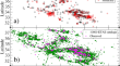
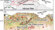
Fluid-driven processes triggering the 2010 Beni-Ilmane earthquake sequence (Algeria): evidence from local earthquake tomography and 4D Vp/Vs models
The 2010 Beni-Ilmane earthquake sequence, with 3 Mw ≥ 5.2 mainshocks, occurred in the southern Tellian Atlas approximately 200 km southeast of the...
-
Coulomb Stress Change of the 2012 Indian Ocean Doublet Earthquake
The 2012 Sumatra (Mw 8.6) earthquake, which falls into the largest and rarest group of the great intraplate earthquakes, continues to awe many...
-
Seismic effects at GPS stations: Case study of the 24 August 2016 Amatrice earthquake
The seismic event of the 2016 Amatrice earthquake and its subsequent aftershocks have provided a significant opportunity to study seismic waves and...