Search
Search Results
-
GRIMS: global and regional ionosphere monitoring system
The ionosphere shows regular changes such as daily, 27 days, seasonal, semi-annual, annual, and 11 years. These changes can be modeled and their...

-
Detecting outliers in local ionospheric model for GNSS precise positioning
Global Navigation Satellite System fast precise positioning can be achieved with accurate ionospheric corrections computed from an adequate number of...

-
Characteristics of Beidou-2 flex power and its impact on precise point positioning with ambiguity resolution
The modernization of the Global Navigation Satellite Systems (GNSS) has brought many new features and capabilities, one of which is programmable...

-
M_IFCB: a MATLAB-based software for multi‑GNSS inter‑frequency clock bias estimation and forecast
To address the lack of publicly available inter-frequency clock bias (IFCB) products and the impact of IFCB on real-time or near-real-time...

-
Integrated satellite clock and code/phase bias combination in the third IGS reprocessing campaign
In the third reprocessing campaign (repro3) initiated by the International GNSS Service (IGS), 11 analysis centers (ACs) reanalyzed...

-
Improving the stochastic model for code pseudorange observations from Android smartphones
In recent years, there has been increasing attention to positioning, navigation, and timing applications with smartphones. Because of frequently...
-
Observations and positioning quality of low-cost GNSS receivers: a review
Over the past two decades, low-cost single-frequency Global Navigation Satellite System (GNSS) receivers have been used in numerous engineering...

-
LSTM-based clock synchronization for satellite systems using inter-satellite ranging measurements
The inter-satellite link (ISL) has been received increasing attention, as it is a potential way to achieve autonomous clock synchronization for...

-
GNSS spoofing detection using a fuzzy classifier based on time–frequency analysis of the autocorrelation function
We present a method to detect spoofing attack in Global Navigation Satellite System signals for single antenna receivers based on autocorrelation...

-
Assessment of ZWD field predictions using the dynamic mode decomposition method
The existing water vapor present in the lower regions of the atmosphere plays a pivotal role in both weather forecasting and the propagation of...

-
GLONASS-K attitude: rapid turning maneuvers and other deviations from ideal yaw steering
This paper provides a description of the GLONASS-K yaw turn maneuvers that regularly occur at orbit noon and orbit midnight when the Sun’s elevation...
-

-
GLONASS-K2 signal analysis
K2 is a new generation of GLONASS satellites that provides code division multiple access (CDMA) signals in the L1, L2 and L3 frequency bands in...

-
Precise positioning utilizing smartphone GNSS/IMU integration with the combination of Galileo high accuracy service (HAS) corrections and broadcast ephemerides
The Galileo High Accuracy Service (HAS) has undergone substantial development in recent years, offering users free access to GPS and Galileo...

-
POSMind: develo** a hierarchical GNSS/SINS post-processing service system for precise position and attitude determination
The School of Geodesy and Geomatics at Wuhan University has developed a GNSS/SINS post-processing service system named POSMind. With the growing...

-
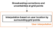
Regional ionospheric correction generation for GNSS PPP-RTK: theoretical analyses and a new interpolation method
The regional ionospheric corrections have become one of the critical parts of Precise Point Positioning (PPP)-based Real-Time-Kinematic (RTK)...
-
GDPS: an open-source python-based software package for multi-GNSS data preprocessing
Global Navigation Satellite System (GNSS) data preprocessing is crucial for achieving high-precision navigation, positioning, and timing applications...

-
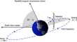
Point positioning the geocenter through LEO GPS tracking and its application in geophysics
We distinguish between geocenter location and geocenter motion for their different purposes: precise orbit determination (POD) and earth surface mass...

-
Determining the optimal thin layer height for single-station ionospheric modeling and its influence on the estimation of DCB
The thin layer ionospheric height (TLIH) is a crucial parameter of the map** function (MF), directly impacting the accuracy of converting slant...

-
A multi-scale adaptive grid partition method based on two-dimensional Fourier transform for ZTD
Grid partitioning plays a crucial role in real-time zenith total delay (ZTD) modeling. However, commonly employed methods rely on empiricism to...
