Search
Search Results
-
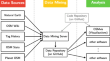
Open source data mining infrastructure for exploring and analysing OpenStreetMap
OpenStreetMap and other Volunteered Geographic Information datasets have been explored in the last years, with the aim of understanding how their...
-
Humans As Sensors in Urban Digital Twins
Digital twins have gained increasing attention as a tool to facilitate decision-making in the cities. However, the current discourse predominantly...
-
Map** Invisible and Inaccessible Areas of Brazilian Cities to Reduce Inequalities
This account of the experiences of the first YouthMappers chapter in Brazil aims to present the work done by Mapeadores Livres UFPR focusing on the...
-
Introduction
In an era of global challenges – from climate change to economic unrest to social disruption to pandemics – the need to hear from voices of the next...
-
Where Is the Closest Health Clinic? YouthMappers Map Their Communities Before and During the COVID-19 Pandemic
YouthMappers chapters are both locally and globally situated, fostering a confluence of community input, GIS skill sets, subject-matter expertise,...
-
The Ecosystem Where YouthMappers Live and Thrive
YouthMappers live and thrive in an ecosystem of university chapters, organizers, sponsors, ambassadors, and partners. This system places youth at the...
-
Understanding YouthMappers’ Contributions to Building Resilient Communities in Asia
This chapter considers the contributions of YouthMappers chapters in Asia. In addition to a regional overview, we highlight actions of students in...
-
Power Grid Map** in West Africa
YouthMappers helps to map fundamental features of rural communities across the countryside of Sierra Leone as an innovative model for how to bring...
-
Mentoring Experiences in YouthMappers Chapters
YouthMappers brings together university students coalesced around institutional chapters carrying out collaborative map** to address humanitarian...
-
Geospatial Data Literacy: Considering the Multisensory Perspective
The competence applied to the selection, (critical) evaluation and usage of modern spatial data resources (geospatial data literacy) is of increasing...
-
Seeing the World Through Maps: An Inclusive and Youth-Oriented Approach
Through YouthMappers, young women students are able to design and participate in activities that collect, create, and disseminate spatial data and...
-
Drones for Good: Map** Out the SDGs Using Innovative Technology in Malawi
Drones are being used in various industries, focusing on youth involvement and map** activities as a key component of the multiple initiatives....
-
Map** for Women’s Evacuation Plans During Climate-Induced Disasters
Increasingly disasters like floods, droughts, cyclones, and heat waves are recurring in the wake of climate change impacts. Women and children are...
-
A framework for annotating OpenStreetMap objects using geo-tagged tweets
Recent years have witnessed an explosion of geospatial data, especially in the form of Volunteered Geographic Information (VGI). As a prominent...

-
Context-Driven Tourist Trip Planning Support System: An Approach and OpenStreetMap-Based Attraction Database Formation
The number of tourists has significantly increased recently. In 2016, the total number of tourists in the world became more than one billion. People...
-
Open GIS for Disasters
When a disaster event occurs, managers, responders, and the general public need timely geospatial data generated from various sources (e.g.,...
-
Open Data Addressing Challenges Associated with Informal Settlements in the Global South
The United Nations estimates that 3 billion people living in urban contexts will need adequate and affordable housing by 2030. We urgently need...
-
Leveraging Spatial Technology for Agricultural Intensification to Address Hunger in Ghana
YouthMappers are using open geospatial tools in support of initiatives seeking to achieve SGD 2 Zero Hunger and SDG 1 No Poverty in Northern Ghana....
-
Open Data
Data is a fundamental element of GIS, but spatial data can often be expensive, limited, or confidential due to its nature. With the advance of the...
-
Open Map** towards Sustainable Development Goals Voices of YouthMappers on Community Engaged Scholarship
This collection amplifies the experiences of some of the world’s young people who are working to address SDGs using geospatial technologies and...