Search
Search Results
-
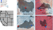
Area-to-point regression Kriging approach fusion of Landsat 8 OLI and Sentinel 2 data for assessment of soil macronutrients at Anaimalai, Coimbatore
Spectral indices-based soil prediction models derived from multispectral datasets are too intricate in terms of accuracy as well as resolution....

-
Comparative assessment of deep belief network and hybrid adaptive neuro-fuzzy inference system model based on a meta-heuristic optimization algorithm for precise predictions of the potential evapotranspiration
Accurately predicting potential evapotranspiration (PET) is crucial in water resource management, agricultural planning, and climate change studies....

-
The Determination of Plumb Line Deviation Using Satellite/Levelling Technique
The article deals with adopting the GNSS/levelling technique to calculate the plumb line deviation. The topic focuses on the possibility of...
-
Application and Control of Quadrotors
A quadrotor is a multirotor helicopter, boosted by four rotors. In contrast to fixed-wing aircraft, quadrotors are categorized as rotorcraft, since...
-
Continuous monitoring system of gob temperature and its application
Due to the concealment of the fire source in the gob, the fire prevention and extinguishing work in the gob is facing great difficulties. This study...

-
New Technologies to Implement Precise Management of Farming in a City
Robotics is a key technology to innovate various industries such as manufacturing, medical care, nursing care, transportation, and agriculture. The...
-
Global Positioning System
In the previous chapters, you have learnt about remote-sensing technology which is one of the reliable sources of the spatial database. In this...
-
Breaking the Rules: Towards an Experimental Design Pedagogy
The Great Game is a laboratorial course that problematises the traditional design studio approach, seeking for reframed modes of knowledge...
-
Elastic deformation as a tool to investigate watershed storage connectivity
Storage-discharge relationships and dynamic changes in storage connectivity remain key unknowns in understanding and predicting watershed behavior....
-
Urban Heat Island Monitoring with Global Navigation Satellite System (GNSS) Data
The Urban Heat Island (UHI) effect occurs when the temperature in an urban area is higher than the temperature in a rural area. UHIs are generally...
-
School is not enough: The role of climate-specific knowledge for transformative climate policy and economic system preferences
Despite risen awareness of human-made climate change, there are still gaps in knowledge about the precise nature and the impact of the climate crisis...

-
Geomatic tools used in the management of agricultural activities: a systematic review
Managing agricultural activity encompasses technology, geographic information, spatial data and geomatic tools as support techniques. In this...

-
Atmospheric radiocarbon levels were highly variable during the last deglaciation
Radiocarbon dating provides a key chronological framework for studying past environmental changes. Raw radiocarbon ages measured in samples must be...

-
Comparison of the monitoring of surface deformations in open-pit mines with Sentinel-1A and TerraSAR-X satellite radar data
In case necessary precautions are not taken in surface mines, serious accidents and loss of life may occur, particularly due to large mass...

-
A multi-step water quality prediction model based on the Savitzky-Golay filter and Transformer optimized network
Effective water quality prediction techniques are essential for the sustainable development of water resources and implementation of emergency...

-
How to effectively promote the transformation of ecological and environmental scientific and technological achievements? A case study from China
AbstractAs an important driving force to improve the quality of ecological environment, there is a problem of poor transformation of ecological and...
-
Indoor Navigation of an Autonomous Guided Vehicle Using ArUco Markers
Autonomous guided vehicles (AGVs) are an important means of making transportation, logistics, and intra-logistics more environmentally friendly....
-
On the performance of streamflow gauging using CCTV-integrated LSPIV in diverse hydro-environmental conditions
Addressing the critical need for precise streamflow measurements in hydro-environmental research, this study evaluates large-scale particle image...

-
Evaluate the exposure of toxic metals via drinking water and smoking nonbranded cigarette in malnourished women by modified single/two-step cloud point extraction
Presently, the exposure of heavy metals (cadmium and lead) was determined in biological sample (serum) of women (pregnant and nonpregnant) who belong...

-
Assessing subsidence of Mexico City from InSAR and LandSat ETM+ with CGPS and SVM
This study presents an enhanced analysis of the subsidence rates and their effects on Mexico City. As a result of excess water withdrawal, Mexico...
