Search
Search Results
-
An effective automatic processing engine for improving the multi-GNSS constellation precise orbit prediction
Orbit prediction (OP) recently tends to be a very crucial step for supporting real-time GNSS orbit services due to the dynamic stability of...

-
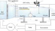
Wake flow field of a wall-mounted pipe with spoiler on a rough channel bed
This research work focuses on the wake flow region of a cylinder with a spoiler on a rough bed under steady flow conditions. The acoustic Doppler...
-
Unsupervised learning-based satellite selection algorithm for GPS–NavIC multi-constellation receivers
The lower bound of the GDOP is an important parameter to benchmark satellite selection algorithms. Existing GDOP lower bound formulations do not...

-
BDS-3 precise orbit and clock solution at Wuhan University: status and improvement
With the rapid deployment of the third-generation satellites of the BeiDou Navigation Satellite System (BDS-3), Wuhan University (WHU) has...

-
Development trends of the national secure PNT system based on BDS
Satellite navigation systems are vulnerable. To guarantee the positioning, navigation and timing (PNT) safety of core infrastructure, it is necessary...
-
5G Impacts analysis on the Beidou RDSS system in 2.5 GHz band
Beidou and 5G systems are important national-level basic projects. Beidou’s Radio Determination Satellite Service (RDSS) provides a unique service...

-
Benefits of BDS-3 B1C/B1I/B2a triple-frequency signals on precise positioning and ambiguity resolution
BDS-3 currently has 28 operational satellites in orbit, of which 27 IGSO/MEO satellites provide open services on five frequencies simultaneously. In...

-
Initial results of distributed autonomous orbit determination for Beidou BDS-3 satellites based on inter-satellite link measurements
Autonomous orbit determination (AOD) is the ability of navigation satellites to estimate with accurate satellite orbit parameters using onboard using...

-
Frequency design of LEO-based navigation augmentation signals for dual-band ionospheric-free ambiguity resolution
Due to the spectrum congestion of current navigation signals in the L-band, it is difficult to apply for another two proper frequencies in this band...

-
Exploring characteristics of BDS-3 PPP-B2b augmentation messages by a three-step analysis procedure
This study discovers three critical characteristics of PPP-B2b augmentation messages, potentially improving positioning continuity and accuracy for...

-
Ionospheric scintillation characteristics over Indian region from latitudinally-aligned geodetic GPS observations
Ionospheric scintillations pose one of the biggest threats to Satellite-Earth communication links in the communication and navigation systems...
-
A unified model of multi-GNSS and multi‑frequency precise point positioning for the joint estimation of ionospheric TEC and time-varying receiver code bias
The short-term variability in receiver code biases (RCBs) has been identified as a prominent source of error leading to the degradation of precise...

-
CroCoord v1.0—An Android Application for Nearly Real-Time 3D PPP Multi-frequency Multi-GNSS Static Surveying Using Smartphones
The hardware of new-generation smartphones enables navigation, positioning and surveying (NPS) using Global Navigation Satellite Systems (GNSS)....
-
Performance of Galileo satellite products determined from multi-frequency measurements
Each Galileo satellite provides coherent navigation signals in four distinct frequency bands. International GNSS Service (IGS) analysis centers (ACs)...

-
A full-polarization GNSS-R Delay-Doppler-Map (DDM) simulator for bare soil freeze/thaw process detection
The soil freeze/thaw processes have a significant impact on the surface energy and moisture balance, which play a key role in ecosystem diversity and...

-
Identification of Groundwater Prospect in Bara Region of Allahabad District Based on Hydro-Geomorphological Analysis Using Satellite Imagery
Water scarcity is a major problem for villagers’ survival as it determines the population density and affects the migration pattern in Bara region....
-
Empirically derived model of solar radiation pressure for BeiDou GEO satellites
A key limitation in the precise orbit determination (POD) of BeiDou geostationary Earth orbit (GEO) satellites is the relatively static observation...

-
Design and implementation of an open-source BDS-3 B1C/B2a SDR receiver
GNSS software-defined radio (SDR) receiver has been and will continue to be a tremendous research enabler given its flexibility and GNSS...

-
Towards Millimeter-Level Accuracy in GNSS-Based Space Geodesy: A Review of Error Budget for GNSS Precise Point Positioning
The aim of the new generation of Global Geodetic Observing System is a millimeter-level accuracy in positioning, with a crucial role to be played by...

-
GNSS satellite-based augmentation systems for Australia
We provided an overview of various satellite-based augmentation systems (SBAS) options for augmented GNSS services in Australia, and potentially New...
