Search
Search Results
-
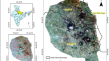
Categorisation of mango orchard age groups using Object-Based Image Analysis
Map** and characterisation of orchards are the foremost steps in the process of orchard monitoring. This study characterised mango orchards, an...
-
Experimental study of the low salinity water injection process in the presence of scale inhibitor and various nanoparticles
In this work, the process of low salinity water injection (LSWI) into reservoirs at various salt concentrations was simulated in order to study the...

-
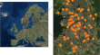
Using Artificial Neural Networks and Spectral Indices to Predict Water Availability in New Capital (IKN) and Its’ Surroundings
This study aims to predict water availability in New Capital (IKN) and its surroundings using artificial neural networks and spectral indices as...

-
Enhanced Oil Recovery from a Carbonate Reservoir During Low Salinity Water Flooding: Spontaneous Imbibition and Core-Flood Methods
Spontaneous imbibition and core flooding investigations were carried out on limestone core plug samples using different low salinity water (LSW) and...
-
Satellite-Based Light Use Efficiency Model for Sugarcane Yield Estimation at Field Scale
Sugarcane is a major cash crop grown in India. Several empirical, semi-empirical and mechanistic models have been used to compute and predict...

-
A path analysis approach to model the gross primary productivity of mangroves using climate data and optical indices
The present study targets modeling the mangrove’s gross primary productivity (GPP) through path analysis using Sentinel-2 satellite-derived optical...

-
Satellite-based assessment of hailstorm-affected potato crop for insurance purpose
Assessing the extent of hailstorm-affected crop is one of the thrust areas for quantifying mid-season adversities under crop insurance values chain....

-
Effect of atmospheric conditions and VPRM parameters on high-resolution regional CO2 simulations over East Asia
Atmospheric CO 2 concentrations are largely affected by the surface CO 2 flux and atmospheric wind. To estimate atmospheric CO 2 concentrations over...

-
Seasonal Dynamics of Vegetation on Fallow Lands in Krasnoyarsk Forest Steppe According to Terrain and Satellite Data
AbstractThis article presents investigation data on the seasonal dynamics of productivity, status, and species composition of vegetation on fallow...

-
Map** of potentially toxic elements in the urban topsoil of St. Petersburg (Russia) using regression kriging and random forest algorithms
The world's largest cities are characterized by environmental pollution, which endangers human health and biological species. Therefore,...
-
Field-scale Assessment of Sugarcane for Mill-level Production Forecasting using Indian Satellite Data
Estimating sugarcane ( Saccharum officinarum L. ) production at micro-scale prior to harvest is required for fixing of Fair and Remunerative Price...

-
Optimization of engineered water injection performance in heterogeneous carbonates: a numerical study on a sector model
One of the emerging technologies for boosting oil recovery in both sandstone and carbonate reservoirs is engineered/low-salinity water injection...

-
Study on monitoring water area in irrigation area by local space self-correlation index
Landsat remote sensing image is a widely used data source in water remote sensing. Normalized difference water index (NDWI), modified normalized...

-
Comparative performance of semi-empirical based remote sensing and crop simulation model for cotton yield prediction
Early prediction of crop yield serves as a strategic plan for policymakers in making suitable import–export policies. In this research, remote...

-
Geochemical evaluation of low salinity hot water injection to enhance heavy oil recovery from carbonate reservoirs
Although low salinity water injection (LSWI) has recovered residual oil after the conventional waterflood, highly viscous oil has remained in heavy...

-
Extraction of Surface Water Bodies using Optical Remote Sensing Images: A Review
Surface Water Map** (SWM) is essential for studying hydrological and ecological phenomena. SWM holds significant importance in water resource...

-
Map** paddy rice in Jiangsu Province, China, based on phenological parameters and a decision tree model
Timely and accurate map** of rice planting areas is crucial under China’s current crop** structure. This study proposes a new paddy rice map**...
-
RETRACTED ARTICLE: Research on green plant development and forest asset accounting based on GIS system data
Forest ecosystem is the main body of terrestrial ecosystem. Quantifying the overall productivity (GPP) of the forest ecosystem and analyzing the...

-
Usage of Satellite Technology in Monitoring the Wetlands of Turkey, Tigris, and Euphrates Watershed
With the increase of anthropogenic activities, the importance of the essence of life, water, proportionally continues to rise. The effective use of...
-
Towards Fine-Scale Yield Prediction of Three Major Crops of India Using Data from Multiple Satellite
There is enormous scope and prospective of crop yield prediction at finer scale for both farm-level crop management as well as for crop insurance...
