Search
Search Results
-
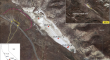
Seismic Site Response Studies for the Indo-Gangetic Plains of India with Special Emphasis on the Narora Nuclear Power Plant
The Indo-Gangetic Plains (IGP), India, is one of the most seismically vulnerable regions due to its proximity to the Himalayan earthquakes. In this...

-
Satellite Remote Sensing-based Long-Term Spatio-Temporal Study of Vanishing Dry Fluvial Channels in Parts of Foothills of North-Western Himalayas and Indo-Gangatic Flood Plains, India
This study develops a workflow to quantify and map long-term (1990–2020) changing land cover, especially of the fluvial systems, in parts of the...

-
Identification of surface water-groundwater interaction using hydrochemistry and multivariate statistical technique in the alluvial plain of Nagaland, India
The identification of terrestrial water bodies and underground water interaction is crucial in the effective management and development of aquifer...

-
Identification of morphometric features of alluvial fan and basins in predicting the erosion levels using ANN
The aim of this study was to investigate the morphometry of alluvial fans and predict the soil erosion located in the vicinity of the Sabzevar,...

-
High Plains groundwater isotopic composition in northeastern New Mexico (USA): relationship to recharge and hydrogeologic setting
In the High Plains (HP) region of northeastern New Mexico (NE NM), USA, underlying bedrock aquifers are utilized where the High Plains Aquifer is...

-
Little Ice Age flood events recorded in sag pond sediments in the Carrizo Plains National Monument, California
In California, severe precipitation events (SPEs) are often associated with winter season atmospheric rivers. These SPEs can generate hurricane-scale...
-
Appraisal of hydrogeological framework of shallow aquifer system of Dimapur alluvial plain of Nagaland in Northeastern India
The hydrogeological framework appraising the groundwater flow system, movement, aquifer occurrence, disposition, and prospect has been examined in...

-
Analysis of hydraulic conductivity characteristics of alluvial sequence in North China Plain
Hydraulic conductivity is a basic property of rocks and soil, and its estimation varies as a function of the scale and purpose of the study. This...

-
Review: Hydrogeology of Northern Mendoza (Argentina), from the Andes to the eastern plains, in the context of climate change
In the drylands of Northern Mendoza, Argentina, water supply depends on rivers and groundwater. Climate change makes this region vulnerable due to...

-
Overbank sedimentation and its influence on channel avulsion: examples of the Cretaceous Tando and Namyang basins in the mid-western part of the Korean Peninsula
The channel arrangements on alluvial plains control the sediment dispersal patterns and stratigraphic architectures, and understanding of alluvial...
-
Liquefied sites of the 2012 Emilia earthquake: a comprehensive database of the geological and geotechnical features (Quaternary alluvial Po plain, Italy)
This paper presents a comprehensive geological and geotechnical study of the whole area affected by liquefaction following the 2012 Emilia...

-
An Appraisal of Geoheritage Potential: From The Delhi-Aravalli Fold- and The Himalayan Fold-Thrust Belts to the Coastal Plains of India
The concept of “geoheritage” that has emerged as a new discipline over the last few years has advocated for the preservation of geological features,...
-
Soil Properties-Landform Relationship in Purvanchal Range of Tripura, Northeastern India: An Implication of Pedogenesis
Twenty two pedons from four landforms namely, hills, mounds, valleys and alluvial plains of Purvanchal range of Tripura, India having warm to hot...
-
Representing rainfall extremes over the Indo-Gangetic Plains using CORDEX-CORE simulations
The Indo-Gangetic Plain (IGP), which is the site of India's Green Revolution, covers almost 15% of the country's landmass and is among the most...

-
Fluoride contamination in groundwater of intensively cropped Upper Yamuna alluvial basin of India: A hydrogeochemical, human health risk assessment, and multivariate statistical perspective
The research is focused on a multivariate statistical approach to assess the groundwater quality, hydrogeochemistry, and human health risk in...

-
Geoelectrical imaging and spatial distribution of alluvial materials of the Sanaga River (Cameroon, Central Africa)
Recent research has shown that the floodplains of the Sanaga river catchment contain significant resources of minerals suitable for industry....
-
Site characterization of strong-motion stations of Himalaya and adjoining plains
Site investigation is crucial for any strong-motion station’s installation due to the modifications caused by underlying soil strata on strong-motion...

-
Interaction between surface waters and the Quaternary shallow alluvial aquifer of Lake Maga downstream: influence of ponds, streams, irrigation canals, and geological features (Far North, Cameroon)
The valorization of Lake Maga for agricultural purposes has not only contributed to the socio-economic development of the study area, but has also...
-
Hydrological Process Simulation of Sluice-Controlled Rivers in the Plains Area of China Based on an Improved SWAT Model
The construction and operation of sluices and dams inevitably change the natural state of river hydrology and have an impact on river ecosystems....

-
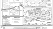
Map** of the Buried Paleochannels on the Terminal Fans in the Western Ganga Plain: A Geomorphological and Ground Penetrating Radar-based Approach
Paleochannels are valuable tools for delineating tectonics, climate, anthropogenic activities, reconstructing the paleogeography, and studying the...