Search
Search Results
-
Identification of erosion-prone areas using morphometric, hypsometric, and compound factor approaches in the Ruvu River Basin, Tanzania
Erosion status resulting from the denudation process in data-limited basins can be achieved through analysis of hydro-morphological parameters. This...

-
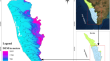
Delineating hydro-geologically constrained groundwater zones in the Himalayan River basins of India through an innovative ensemble of hypsometric analysis and machine learning algorithms
Hydro-geologically constrained groundwater (HGCG) zones have restricted water-holding capacity and low natural recharge rates, leading to reduced...

-
Geomorphological analysis of tropical river basins in southern Kerala using hypsometric indices and neotectonic proxies
Evolutionary geomorphologic stages of tropical river basins of southern Kerala, southwest India were investigated through the state-of-the-art...
-
Using Spatial Autocorrelation for the Hypsometric Integral to Differentiate Geology and Neotectonics: A Case Study in Bailongjiang Drainage Basin (Eastern Tibet Plateau)
Hypsometric integral (HI) has been widely used in Geomorphology study as an index to depict the recent and active structures for its sensitivity to...
-
Hypsometric changes in urban areas resulting from multiple years of mining activity
The impact of multiple years of underground mining of minerals on changes in the elevation of an urban area has been evaluated using the case study...

-
GIS-Based Comparative Assessment of Erosional Status in Two Tropical River Basins
Hypsometric analysis is a powerful tool in identifying geomorphic stages and erosion status of a river basin. This study focuses on conducting...
-
Assessing the level of river basin evolution, erosion susceptibility and its correlation with morphometric characteristics using Geoinformatics techniques
The application of Geoinformatics have become fastest and improved advanced tools to analyse and interpret the topography and hydrological...

-
Comparative analysis of two geologically similar and meteorologically distinct river basins of the Peninsular India
Morphometric and hypsometric parameters provide insight into the drainage and erosional behavior of a river basin. In this work, the morphometric...

-
Hydrocarbon Preservation Conditions in the Productive Series
Vertical migration from the pools to the surface is controlled by the pool’s hypsometric position, by the density of tectonic fractures and joints...
-
Tectonism and Drainage Responses: Insights from the Siang River Basin
Siang River, the upstream subbasin of the mighty Brahmaputra in northeast India, enters the Indian territory from the Tibetan plateau through the...
-
Age and Formation Mechanisms of Baikal Terraces
AbstractA critical analysis is made of the available published ideas concerning the role of the leading factors in the formation of Baikal terraces:...

-
Evaluation of the influence of soil mechanical parameters on the position of rainfall thresholds for shallow landslides
A phenomenon of natural origin that is part of our landscapes is shallow landslides, which have been accelerated by human activity in pursuit of...

-
Evolution stage, spatial and temporal variabilities of granite landforms in the Mount Wugongshan in Jiangxi Province of South China
Granites of the Mesozoic Era are widespread in South China, and many of them have been shaped into spectacular landscapes with high tourism...
-
Prioritization and Quantitative Assessment of Dhundsir Gad Using RS and GIS: Implications for Watershed Management, Planning and Conservation, Garhwal Himalaya, Uttarakhand
The utilization of morphometric parameters in watershed management and conservation has reduced the work, time, manpower and expenditure immensely....
-
Influence of Neotectonics on Channel Evolution of Kameng River, North–East Himalaya
In this study, we addressed the impact of neotectonics on channel evolution of the Kameng River of North–East Himalaya. To the end we used ArcGIS...
-
Assessment and Prioritization of Sub-Watersheds Vulnerable to Soil Erosion in an Ungauged River Basin Using MOORA, COPRAS, MARCOS and MABAC Methods
Identifying soil erosion-prone zones in an ungauged river basin is crucial for devising and implementing timely soil protection measures to mitigate...

-
Coseismic and Tectonic Time-Scale Deformations of an Island Arc Based on the Studies of the East Coast of the Kamchatka Peninsula (Far East, Russia)
AbstractThe geologic structure of the late Holocene accumulative marine terrace on the Kamchatka Bay coast (Kamchatka Peninsula) has been studied....

-
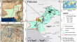
Combined analysis of PS-InSAR and hypsometry integral (HI) for comparing seismic vulnerability and assessment of various regions of Pakistan
InSAR-based deformation analysis and the geomorphic hypsometric integral (HI) technique are powerful tools for assessing the susceptibility and...
-
Evaluation of tectonic activity in the Kopongo area, southwestern Cameroon: insights from geomorphic indices, remote sensing, and GIS
Geomorphologic investigations were undertaken in the Kopongo region, located in the northwestern margin of the Congo craton. The study carry out on...

-
Proposing a novel geo-structural model for Torbat-e- Jam-Fariman plain (Northeast of Iran), based on Geomorphic indices calculation, conjugating the field evidences
There are various faults in northern and southern margins of Torbat-e- Jam-Fariman plain which show the probability of enormous earthquake in the...