Search
Search Results
-
A unifying modelling of multiple land degradation pathways in Europe
Land degradation is a complex socio-environmental threat, which generally occurs as multiple concurrent pathways that remain largely unexplored in...

-
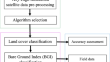
Designing grazing susceptibility to land degradation index (GSLDI) in hilly areas
Evaluation of grazing impacts on land degradation processes is a difficult task due to the heterogeneity and complex interacting factors involved. In...

-
Land cover and forest health indicator datasets for central India using very-high resolution satellite data
Satellite imagery has been used to provide global and regional estimates of forest cover. Despite increased availability and accessibility of...
-
Changes in total and per-capital ecosystem service value in response to land-use land-cover dynamics in north-central Ethiopia
Ecosystems provide a wide range of services crucial for human well-being and decision-making processes at various levels. This study analyzed the...

-
Anthropogenic interventions on land neutrality in a critically vulnerable estuarine island ecosystem: a case of Munro Island (India)
All landscapes, including estuarine islands, normally try to restore their geomorphic isostasy in all anthropogenic interventions on land dynamics....

-
Quantifying peatland land use and CO2 emissions in Irish raised bogs: map** insights using Sentinel-2 data and Google Earth Engine
Ireland has > 50% of the EU’s ocean-raised bogs; however, degradation through land-use activities has transformed them from carbon (C) sinks to...

-
The impact of land transfer policy on sustainable agricultural development in China
At present, China’s agricultural development presents problems such as increasingly tight constraints on water and soil resources, increased...

-
Maximising ecological value and assessing land suitability for sustainable grassland management in Asia’s largest tropical grassland, Western India
Grasslands are crucial ecosystems that provide numerous ecological services and support biodiversity conservation. Grasslands undergo significant...

-
Land conversion to agriculture induces taxonomic homogenization of soil microbial communities globally
Agriculture contributes to a decline in local species diversity and to above- and below-ground biotic homogenization. Here, we conduct a continental...

-
JAXA’s new high-resolution land use land cover map for Vietnam using a time-feature convolutional neural network
Land use land cover (LULC) maps are crucial for various applications, such as disaster management, natural resource conservation, biodiversity...

-
Spatial–temporal evolution characteristics of land use and habitat quality in Shandong Province, China
To explore the sustainable mechanism of land use and habitat quality, the present study examined the land cover data of Shandong Province from 1980...

-
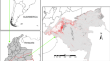
Scenarios of land use and land cover change in the Colombian Amazon to evaluate alternative post-conflict pathways
Pastures and crops have been expanding at an accelerated rate in the forests of the Colombian Amazon since the peace accords were signed in 2016. The...
-
Projected patterns of land uses in Africa under a warming climate
Land-use change is a direct driver of biodiversity loss, projection and future land use change often consider a topical issue in response to climate...

-
Modelling the impact of historic landscape change on soil erosion and degradation
International policies and guidelines often highlight the divide between ‘nature’ and ‘heritage’ in landscape management, and the weakness of...

-
A global land cover training dataset from 1984 to 2020
State-of-the-art cloud computing platforms such as Google Earth Engine (GEE) enable regional-to-global land cover and land cover change map** with...

-
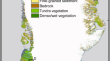
Land cover changes across Greenland dominated by a doubling of vegetation in three decades
Land cover responses to climate change must be quantified for understanding Arctic climate, managing Arctic water resources, maintaining the health...
-
Pathways of degradation in rangelands in Northern Tanzania show their loss of resistance, but potential for recovery
Semiarid rangelands are identified as at high risk of degradation due to anthropogenic pressure and climate change. Through tracking timelines of...

-
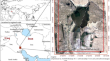
Estimating the severity of landscape degradation in future management scenarios based on modeling the dynamics of Hoor Al-Azim International Wetland in Iran-Iraq border
Temporal and spatial changes in land cover in wetland ecosystems indicate the severity of degradation. Understanding such processes in the past,...
-
Spatio-temporal evolution of land use and its eco-environmental effects in the Caohai National Nature Reserve of China
With the rapid development of social economy, the ecological environment problems caused by the change of wetland land use have been widely...

-
Human degradation of tropical moist forests is greater than previously estimated
Tropical forest degradation from selective logging, fire and edge effects is a major driver of carbon and biodiversity loss
1 –3 , with annual rates...