Search
Search Results
-
Geoinformatics in Theory and Practice An Integrated Approach to Geoinformation Systems, Remote Sensing and Digital Image Processing
This textbook is intended to display a broad, methodological introduction to geoinformatics and geoinformation science. It deals with the recording,...

-
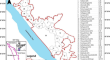
Peri-urban area delineation and urban sprawl quantification in Thiruvananthapuram Urban Agglomeration, India, from 2001 to 2021 using geoinformatics
In Southeast Asia, rising population, economic growth, and lack of land supply in the city core have led to the widespread irreversible land cover...
-
Introduction to Agro-Geoinformatics: Theory and Practices
Agro-geoinformation, the agricultural-related geo-information, is the key information in the agricultural decision making and policy formulation...
-
Big Data and Its Applications in Agro-Geoinformatics
Agro-geoinformatics deals with collecting, managing, and analyzing agricultural-related geospatial data, which are domain-specific big data. This...
-
Agro-geoinformatics Theory and Practice
This volume collects and presents the fundamentals, tools, and processes of utilizing geospatial information technologies to process remotely sensed...
-
Agro-geoinformatics Data Sources and Sourcing
This chapter summarized state-of-the-art data sources and sourcing methods of agro-geoinformatics. The data mainly comes from four sources:...
-
Introduction
Geoinformatics is an interdisciplinary field that bridges the gap between computer science, geographic information technologies and geosciences or...
-
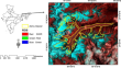
Estimating thickness of Zemu glacier, Sikkim (India) using ice-flow velocity approach: a geoinformatics based perspective
In the present scenario of warming climate, overall health of the glaciers along with sea level rise/fall are directly impacted by glacial dynamics....
-
Geoinformatics and Kala-azar Disease Transmission
Geoinformatics is concerned about georeferenced data input, storage, recovery and addition, image processing operations, spatial analysis tools,...
-
Geoobjects and Reference Systems
The spatial reference of information is a characteristic feature of geosciences and also of geoinformatics. The coupling of information to spatial...
-
Connecting Literature and Web Maps: Hungarian Writers and Poets Online
The Erasmus+ KA201 project, “Biographical map library of European authors” (BIO-MAPS) started in December 2020 with the participation of three...
-
Data Organisation and Database Systems
The storage, management and processing of extensive data are of great significance for all areas of application and therefore also for...
-
Field Survey and Geoinformatic Approaches for Micro-Level Land Capability Classification
Land capability classification (LCC) is useful to carry out scientific land evaluations and assess land suitability for agricultural use. In this...
-
Application of Geoinformatics and AHP Technique to Delineate Flood Susceptibility Zone: A Case Study of Silabati River Basin, West Bengal, India
Among all the natural disasters, floods are the most common phenomena that cause huge obliteration to the human lives and socio-economic and cultural...
-
Air quality disturbance zone map** in greater Cochin region of Kerala state, India using geoinformatics
Air quality disturbance zones of the Greater Cochin region (Kerala, India) for the years 2014, 2015, 2016 and 2017 along with air quality assessment...

-
Geospatial Information Research: State of the Art, Case Studies and Future Perspectives
Geospatial information science (GI science) is concerned with the development and application of geodetic and information science methods for...

-
Geoinformatics for Sustainable Development in Asian Cities
This proceedings volume focuses on the importance and power of spatial thinking and planning, especially by applying geospatial technologies in...
-
Image Processing Methods in Agricultural Observation Systems
Image processing is an essential part of the agricultural observation system. This chapter is the first attempt to provide an overview of the image...
-
Site Suitability Analysis for Identifying Water Conservation Structures Using Geoinformatics of Eastern Part of Satara District of Maharashtra, India
Identification of a suitable site for water harvesting structure is significant for drought mitigation and management. Water conservation needs an...
-
Climate Change Induced Coastal Hazards and Community Vulnerability in Indian Sundarban
Climate change does not have any boundary and the coastal parts of the world are getting affected largely by the climate-induced hazards frequently....