Search
Search Results
-
Gravity anomalies determined from mean sea surface model data over the Gulf of Mexico
With the improvements in the density and quality of satellite altimetry data, a high-precision and high-resolution mean sea surface model containing...
-
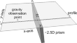
2.5D Regularized Gravity Data Inversion for the Detection of Faults in Basement Rocks
We have developed a basement fault detection technique (the so-called NVDTH) enhanced by regularized inversion of gravity data to improve the...
-
3D gravity inversion using cycle-consistent generative adversarial network
Gravity inversion is an important approach for obtaining the spatial structure and physical properties of underground geological bodies based on...
-
Modeling and Inversion of Potential Field Data
This chapter illustrates the inversion methods discussed in the book by joint inversion of potential field geophysical data. Methods of forward...
-
Case Histories of Joint Inversion of Gravity and Magnetic Data
This chapter presents several case histories of joint inversion of potential field geophysical data as an illustration of the joint inversion methods...
-
Steep subduction of the Indian continental mantle lithosphere beneath the eastern Himalaya revealed by gravity anomalies
The geometry and deformation of the Indian continental mantle lithosphere (ICML) beneath the India-Eurasia collision zone are critical to...
-
Modified Barnacles Mating Optimizing Algorithm for the Inversion of Self-potential Anomalies Due to Ore Deposits
The self-potential method (SP) has been used extensively to reveal some model parameters of various ore deposits. However, estimating these...

-
Gravity interpretation using modified preconditioned conjugate gradient and reweighting of inversion methods: a case study from Iran
This study, a reweighting focusing (RF) inversion and modified preconditioned conjugate gradient (MPCG) inversion methods are described, and then,...
-
Backtracking Search Optimization: A Novel Global Optimization Algorithm for the Inversion of Gravity Anomalies
In this paper, an implementation of Backtracking search optimization (BSA), a non-gradient iterative evolutionary algorithm, is presented for model...

-
An analysis and comparison of automated methods for determining the regularization parameter in the three-dimensional inversion of gravity data
The processing of potential field datasets requires many steps; one of them is the inverse modeling of potential field data. Using a measurement...

-
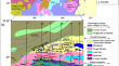
Three-dimensional constrained gravity inversion of Moho depth and crustal structural characteristics at Mozambique continental margin
Mozambique’s continental margin in East Africa was formed during the break-off stage of the east and west Gondwana lands. Studying the geological...
-
Automatic inversion of magnetic anomalies caused by 2D listric fault sources with arbitrary magnetisation
An automatic inversion technique is presented to analyse the magnetic anomalies produced by 2D fault sources having nonplanar fault planes. This...

-
Characteristics of gravity anomalies and tectonic analysis of Enderby Land in East Antarctica and its adjacent areas
Enderby Land in East Antarctica and its adjacent areas, which are closely related to the Indian Plate in their geological evolution, have become one...
-
Accuracy requirement for altimetry observations for bathymetry inversion using gravity anomaly and gravity gradients
The gravity anomaly and vertical gravity gradient obtained from satellite altimetry observations play a great role in global bathymetry inversion. In...

-
3D Inversion of Gravity and Aeromagnetic Data over the Western North Singhbhum Mobile Belt, Eastern Indian Shield, for Delineating Prospective Sulfide (Au) Mineralization Zones
The North Singhbhum Mobile Belt is an important metallogenic province in the Eastern Indian shield, and it hosts significant reserves of gold,...
-
Uncertainty Quantification and Field Source Inversion for the Continental-Scale Time-Varying Gravity Dataset: A Case Study in SE Tibet, China
Southeastern (SE) Tibet on the Chinese mainland is geologically active and plays an important role in subsurface deformation and mass transfers....

-
Global marine gravity anomalies from multi-satellite altimeter data
In this study, China’s first altimeter satellite Haiyang-2A (HY-2A) data combined observations from CryoSat-2, SARAL/AltiKa, and Jason-1&2 are used...

-
Identification of sediment–basement structure in West Papua province, Indonesia, using gravity and magnetic data inversion as an Earth’s crust stress indicator
West Papua province in eastern Indonesia is positioned in a dynamic tectonic zone along with the collision of the Australian, Pacific, and Eurasian...

-
Recovering Bathymetry of the Gulf of Guinea Using Altimetry-Derived Gravity Field Products Combined via Convolutional Neural Network
Traditional methods of bathymetry inversion from altimetry data often use gravity anomalies and/or vertical gravity anomaly gradients. These two...

-
Gradient descent fusion for gravity and magnetic data
Subsurface characterization is a crucial aspect of geophysical exploration, enabling the identification and understanding of valuable geological...
