Search
Search Results
-
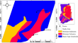
Regional-residual depth estimation and edge detection characterization over the southern Kibi–Winneba belt, Ghana using aeromagnetic data
An essential procedure that facilitates the analysis and interpretation of magnetic anomalies is the use of data enhancement and filtering approaches...
-
Edge detection and depth estimation of Lake Sapanca, Eastern Marmara Region, from high-resolution magnetic data
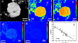
The present study aims to determine submarine structural elements by analysing high-resolution magnetic data sets and to examine the impact of...

-
A novel depth measurement method for urban flooding based on surveillance video images and a floating ruler
In view of the low accuracy and high cost of existing urban flooding monitoring methods, this study proposed a method for measuring the depth of...

-
Fusion of color and hallucinated depth features for enhanced multimodal deep learning-based damage segmentation
Recent advances in computer vision and deep learning have shown that the fusion of depth information can significantly enhance the performance of...
-
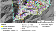
Lineament depth deduction using geomorphometry and 3D Euler solution
In this paper, we present a novel method for determining the depth of lineaments using satellite gravity data, which we test in the Sahel of Sfax...

-
Detection of internal crack growth in polyethylene pipe using guided wave ultrasonic testing
Despite the success of guided wave ultrasonic inspection for internal defect detection in steel pipes, its application on polyethylene (PE) pipe...
-
Design and Realization of Electromagnetic Instrument Data Acquisition Circuit for Landslide Detection
With the rapid development of human society and the surge of engineering construction, the disturbance of the geological environment has grown...
-
Column Optical Depth (COD) Derived from CALIOP Ocean Surface Returns
The Cloud Aerosol Lidar with Orthogonal Polarization (CALIOP) on board the Cloud Aerosol Lidar Infrared Pathfinder Satellite Observations (CALIPSO)...
-
A Novel Depth-Wise Separable Convolutional Model for Remote Sensing Scene Classification
With the advancement in satellite and Artificial Intelligence (AI), the increase in observation of the earth is increasing dramatically. With this...

-
Development of Data Acquisition Software for Electromagnetic Instruments in Landslide Detection
Rapid societal development and increased engineering construction have exacerbated the disturbance of the geological environment. The impact of...
-
Estimation of the Depth to the Magnetic Basement in Europe Using the Spectral Method
Despite several geological and geophysical studies that have focused on the estimation of the geometry of the sedimentary basins, the seismic...

-
Three-dimensional constrained gravity inversion of Moho depth and crustal structural characteristics at Mozambique continental margin
Mozambique’s continental margin in East Africa was formed during the break-off stage of the east and west Gondwana lands. Studying the geological...
-
Implication of alluvial valley width-to-depth ratio on the effect of rock uplift
The ratio of channel width to channel depth (α) is widely used to quantify the valley geometry of natural alluvial river channels. However, rare...
-
Research on the methods for separating wind sea and swell from directional wave spectra in finite-depth waters
Ocean waves are generally a mix of wind sea and swell. Given the significant disparities in their impact on engineering, the separation of wind sea...

-
Shallow sea topography detection using fully Polarimetric Gaofen-3 SAR data based on swell patterns
Compared to single-polarization synthetic aperture radar (SAR) data, fully polarimetric SAR data can provide more detailed information of the sea...
-
A Spatial-Aware Neural Network for Inversion of Shallow Water Depth from WorldView-02 High-Spectral-Resolution Imagery
Remote sensing shallow water depth inversion is to automatically predict the water depth value of 0–30 m based on the extraction of the significative...

-
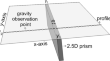
2.5D Regularized Gravity Data Inversion for the Detection of Faults in Basement Rocks
We have developed a basement fault detection technique (the so-called NVDTH) enhanced by regularized inversion of gravity data to improve the...
-
Brittleness ductility transition depth of new fracture in the Baodi Miaozhuang Uplift
Today’s earthquakes are the most direct manifestation of the latest tectonic activity and are the most powerful tool to understand the...
-
Distinct taxonomic and ecological functions of microbiome in sediments of different depth in Bohai Sea and Yellow Sea
Microorganisms in sediments are critical to marine ecosystems. The microbial communities in marine sediments of the Bohai Sea (BS) and Yellow Sea...
-
Depth profiling of arsenian pyrite in Carlin-type ores through wet chemistry
Enrichment of As and Au at the overgrowth rims of arsenian pyrite is a distinctive feature of Carlin-type gold ores. Revealing distribution of such...