Search
Search Results
-
Potential of EOS-04 C-band Synthetic Aperture Radar in Identifying Oceanic Rain Cells
Indian Space Research Organisation (ISRO) launched Earth Observation Satellite (EOS-04) on 14th February, 2022, which is equipped with C-band...

-
Quantifying freeze-melt dynamics of lakes on the Tibetan Plateau using Sentinel-1 synthetic aperture radar imagery
The ice phenology of alpine lakes on the Tibetan Plateau (TP) is a rapid and direct responder to climate changes, and the variations in lake ice...
-
Estimation of Above Ground Biomass with Synthetic Aperture Radar (SAR) Data in Lothian Island, Sundarbans, India
The present study deals with the estimation of aboveground biomass (AGB) using synthetic aperture radar (SAR) data in a highly complex mangrove...

-
Forest Aboveground Biomass and Forest Height Estimation Over a Sub-tropical Forest Using Machine Learning Algorithm and Synthetic Aperture Radar Data
Forest aboveground biomass (AGB) is a key measurement in studying terrestrial carbon storage, carbon cycle, and climate change. Machine learning...
-
Semisupervised heterogeneous ensemble for ship target discrimination in synthetic aperture radar images
Ship detection using synthetic aperture radar (SAR) plays an important role in marine applications. The existing methods are capable of quickly...
-
A novel synthetic aperture radar scattering model for sea surface with breaking waves
In this study a novel synthetic aperture radar (SAR) scattering model for sea surface with breaking waves is proposed. Compared with existing models,...
-
Variance component adaptive estimation algorithm for coseismic slip distribution inversion using interferometric synthetic aperture radar data
When conducting coseismic slip distribution inversion with interferometric synthetic aperture radar (InSAR) data, there is no universal method to...

-
Multiple Signal Classification Algorithm Combined with Volume Reflectivity Models to Improve Accuracy of the Estimated Vegetation Height in Synthetic Aperture Radar Tomography
The aim of this paper lies in improving the accuracy of multiple signal classification (MUSIC) inversion in Synthetic Aperture Radar Tomography...

-
Assessment of the ASAR and PALSAR Sensors Applicability for Detecting and Monitoring of Landslides in the Zagros Area (Iran) Through Differential Synthetic Aperture Radar Interferometry (DInSAR)
Lunching satellites equipped with the Synthetic Aperture Radar (SAR) sensor for interferometry applications has created a great chance to detect and...

-
Drought impact detection on wetlands in the arid area using Synthetic Aperture Radar data
Wetland conservation is crucial in arid areas on account of the high dependence of life on these ecosystems. Quantifying the effects of drought on...

-
EZ-InSAR: An easy-to-use open-source toolbox for map** ground surface deformation using satellite interferometric synthetic aperture radar
Satellite Interferometric Synthetic Aperture Radar (InSAR) is a space-borne geodetic technique that can map ground displacement at millimetre...
-
Oil Pollution in the Kerch Strait Based on Five-Year Monitoring with Synthetic Aperture Radar: Current Status and Main Sources
AbstractThe results of the five-year (2017–2021) monitoring of oil pollution in the Kerch Strait and its prestrait regions are analyzed. The...

-
Oil Spill Identification based on Dual Attention UNet Model Using Synthetic Aperture Radar Images
Oil spills cause tremendous damage to marine, coastal environments, and ecosystems. Previous deep learning-based studies have addressed the task of...
-
Quantitative Assessment of Interferometric Synthetic Aperture Radar (INSAR) for Landslide Monitoring and Mitigation
This work focuses on understanding to what degree the remote sensing tool of Interferometric Synthetic Aperture Radar (InSAR) can be used to...
-
Simulations of Spotlight Synthetic Aperture Radar Super-resolution Algorithm
Aiming at the multi-angle spotlight SAR imaging mode, a multi-angle spotlight SAR super-resolution imaging algorithm is proposed. Multi-angle...

-
Application of the method for prediction of the failure location and time based on monitoring of a slope using synthetic aperture radar
Synthetic aperture radar (SAR) technology has been widely used in landslide deformation monitoring in the past decade. It has the advantages of high...

-
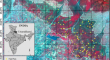
Sentinel-1 Interferometric Synthetic Aperture Radar (InSAR) reveals continued ground deformation in and around Metro Manila, Philippines, associated with groundwater exploitation
Uneven ground deformations resulting from excessive groundwater exploitation have been causing problems in metropolitan cities worldwide. Metro...

-
Integration of historical synthetic aperture radar (SAR) and geotechnical data for monitoring ground instability: a case study of Ismailia District, Egypt
Historical time series of synthetic aperture radar (SAR) and up-to-date geotechnical data were integrated for monitoring ground instability at the...

-
Burnt Area Signal Variations in Agriculture and Forested Landscapes of India—A Case Study Using Sentinel-1A/B Synthetic Aperture Radar
In this study, we report contrasting burnt area signals in Sentinel-1A Synthetic Aperture Radar (SAR) VV polarized data versus Sentinel-2 optical...
-
Synthetic Aperture Radar Interferometry to Measure Earthquake-Related Deformation: A Case Study from Nepal
The Himalayan syntax is located at the collision boundary of the Indian and the Eurasian plates form an arc that extends ~2400 km across the...