Search
Search Results
-
The statistical analysis of training data representativeness for artificial neural networks: spatial distribution modelling of heavy metals in topsoil
A four-step dividing algorithm of sampling points for artificial neural networks is presented to select a representative training subset for...

-
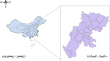
Spatial evolution and spatial production of traditional villages from “backward poverty villages” to “ecologically well-off villages”: Experiences from the hinterland of national nature reserves in China
With the rapid urbanization process, the space of traditional villages in China is undergoing significant changes. Studying the spatial evolution of...
-
Spatial prediction using random forest spatial interpolation with sample augmentation: a case study for precipitation map**
Spatial prediction(SP) based on machine learning(ML) has been applied to soil water quality, air quality, marine environment, etc. However, there are...

-
Incorporation of RCM-simulated spatial details into climate change projections derived from global climate models
Regional climate models (RCMs) exhibit greater potential than global models (GCMs) in capturing geographical details of climate change arising from...

-
Spatial Variability of Alpine Meadow Soils in Gannan Tibetan Autonomous Prefecture, Gansu Province, China
AbstractWe study studied the alpine meadow soil in Gannan Prefecture. Geostatistical analysis showed that Circular [soil total nitrogen (STN), soil...

-
Identification of heavy metal stress in rice using spatial clustering based on time series of crop spectral information
Rice is susceptible to various types of stresses during its growth cycle, including heavy metals, drought, nutritional stress, pests, and diseases,...

-
Exploring the spatial distribution and influencing factors of soil PH value of cultivated land in Sichuan Province
Soil pH is a crucial indicator which greatly reflects the cultivated land fertility. Exploring its spatial distribution characteristics and...
-
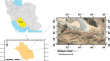
Plant Available Water Capacity in Surface Horizons of Soil with Rock Fragments in an Andean Micro-Watershed: a Spatial Relational Analysis
AbstractPlant available water storage capacity is a vital soil property for vegetation and soil hydrological processes. Different investigations...

-
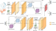
ENSONet: a data-driven ENSO forecasting model with concise spatial location learning parameters and temporal embedding
The El Niño-Southern Oscillation (ENSO) is a highly notable climate phenomenon with significant implications for global weather patterns and climate...
-
Small-Scale Spatial Variation of the Nocturnal Wind Field
This study examines the spatial variability of the nocturnal wind field using eight networks of surface observations ranging in horizontal width from...

-
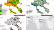
Impacts of climate change on spatial drought distribution in the Mediterranean Basin (Turkey): different climate models and downscaling methods
The impacts of climate change increasingly show themselves in many forms in our everyday lives such as heatwaves and droughts. Drought is one of the...

-
Spatial uncertainty analysis of the saturated soil hydraulic conductivity in a subtropical watershed
The high spatial variability of the saturated soil hydraulic conductivity ( K sat ) and the effort required for its data sampling have been a challenge...

-
Spatial and temporal characteristics of actual evapotranspiration and its influencing factors in Selin Co Basin
Selin Co basin, a representative lake basin situated in the central region of the Tibetan Plateau (TP), is characterized by extensive areas of frozen...

-
Exploring the spatial variability of soil properties using reflectance spectroscopy and magnetic susceptibility techniques in arid lands
The accuracy, speed, and feasibility of studying soil properties depend largely on the techniques used and their efficiency to correlate soil...
-
Spatial Resilience to Wildfires through the Optimal Deployment of Firefighting Resources: Impact of Topography on Initial Attack Effectiveness
Strongly affected by the escalating impacts of climate change, wildfires have been increasing in frequency and severity around the world. The primary...
-
Selection of spatial prediction models of saturated hydraulic conductivity in soils containing rock fragments in an Andean micro-basin
Research has been carried out to evaluate the effects of rock fragments on the hydraulic conductivity of soils; however, spatial relationships have...

-
Impacts of the Urban Spatial Landscape in Bei**g on Surface and Canopy Urban Heat Islands
How does the urban spatial landscape (USL) pattern affect the land surface urban heat islands (SUHIs) and canopy urban heat islands (CUHIs)? Based on...
-
Calibration of the root water uptake spatial distribution of a young Melaleuca styphelioides, an Australian-native plant, by means of a large-scale apparatus experiment
The stability of slopes is greatly influenced by seasonal variations in pore water pressures (pwp) induced by rainfall infiltration and...

-
Spatial Variability of Nocturnal Stability Regimes in an Operational Weather Prediction Model
Forecast errors in near-surface temperatures are a persistent issue for numerical weather prediction models. A prominent example is warm biases...

-
Effects of Different Spatial Resolutions on Prediction Accuracy of Thunnus alalunga Fishing Ground in Waters Near the Cook Islands Based on Long Short-Term Memory (LSTM) Neural Network Model
Albacore tuna (Thunnus alalunga) is one of the target species of tuna longline fishing, and waters near the Cook Islands are a vital albacore tuna...