Search
Search Results
-
An Intense Quantum of Deformation in the Deep Crust as Seen from Geomechanical Modeling in Southern California
AbstractA rapidly develo** high-amplitude shear deformation anomaly in the upper crustal interval (at depths of up to 10 km), the so-called...

-
Strain localization instabilities and the genesis of multiple axes of seafloor spreading in the Carmen basin, southern Gulf of California
We present new insight into the tectonic evolution of the Carmen basin (CB) in the southern Gulf of California (GC) from high-resolution bathymetry...

-
Occurrence Apparent Velocities for Identification and Quantification of Space–Time Clustering Precursory to a Large Earthquake. Application to Large (M > 7.0) Earthquakes in Southern California and Northern Baja California
Space–time seismic clusters, localized bursts of seismic activity, are a feature of background seismicity before the occurrence of large earthquakes,...

-
-
Estimation of the desert dust balance and its relationship with environmental factors in the southern Baja California Peninsula
The emission, transport, and deposition of desert dust are influenced by environmental factors evaluated mainly as a function of precipitation, air...

-
The 2019 Ridgecrest Large Earthquake in Southern California: Studying the Source Formation Based on Geomechanical Modelling
AbstractHere we present a simulation of the crust’s stress–strain state in the period prior to the 2019 Ridgecrest (M = 7.1) earthquake in Southern...

-
Little Ice Age flood events recorded in sag pond sediments in the Carrizo Plains National Monument, California
In California, severe precipitation events (SPEs) are often associated with winter season atmospheric rivers. These SPEs can generate hurricane-scale...
-
Lower crustal assimilation revealed by sulfur isotope systematics of the Bear Valley Intrusive Suite, southern Sierra Nevada Batholith, California, USA
The origin of the wide range of sulfur isotope compositions (i.e., δ 34 S) measured in arc rocks remains debated. While the observed δ 34 S variability...

-
Fusion of GNSS and InSAR time series using the improved STRE model: applications to the San Francisco Bay Area and Southern California
The spatio-temporal random effects (STRE) model is a classic dynamic filtering model, which can be used to fuse GNSS and InSAR deformation data. The...

-
Assessing the Vulnerability of California Water Utilities to Wildfires
Wildfires are becoming more frequent and destructive in California, and it is essential to quantify their potential impacts on drinking water...

-
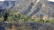
Postfire hydrologic response along the Central California (USA) coast: insights for the emergency assessment of postfire debris-flow hazards
The steep, tectonically active terrain along the Central California (USA) coast is well known to produce deadly and destructive debris flows....

-
Geologic controls on groundwater salinity reversal in North Coles Levee Oil Field, southern San Joaquin Valley, California, USA
This paper documents a reversal in the groundwater salinity depth gradient in the North Coles Levee Oil Field in the San Joaquin Valley, California....

-
Early Manifestations of Short-Term Precursors in Stress-Strain State Dynamics of Southern California
Abstract —The stress-strain state before the М = 7.1 Ridgecrest earthquake in Southern California is analyzed based on spatiotemporal distribution of...
-
Calculation of maximum earthquake accelerations in a semi-empirical way for southern Gulf of California extensional province, Mexico
The Gulf of California (GoC) is an extensional province where the North America and Pacific plates limit. The boundary is an echelon set of normal...

-
Solid-earth tidal modulations of 2019 Ridgecrest earthquake sequence, California: any link with Coso geothermal field?
We report solid-earth tidal modulation of early aftershocks of the July 2019 Ridgecrest earthquake sequence, which occurred close to the southeastern...
-
Winter wet–dry weather patterns driving atmospheric rivers and Santa Ana winds provide evidence for increasing wildfire hazard in California
Floods caused by atmospheric rivers and wildfires fanned by Santa Ana winds are common occurrences in California with devastating societal impacts....

-
Stress State Dynamics in Southern California from Geomechanical Monitoring Data before the М = 7.1 Earthquake of July 6, 2019
Abstract —Since 2009, the stress-strain state (SSS) of the Earth’s crust in Southern California has been monitored using geomechanical modeling that...

-
Geodiversity Assessment in the Midriff Islands Region of the Gulf of California (Northwest Mexico)
A concurrent qualitative-quantitative assessment of geodiversity was carried out within the Midriff Islands, a priority region within...
-
Groundwater response to climate variability in Mediterranean type climate zones with comparisons of California (USA) and Portugal
Aquifers are a fundamental source of freshwater, yet they are particularly vulnerable in coastal regions with Mediterranean type climate, due to both...

-
San Felipe Geothermal Prospect: A Previously Unrecognized Hydrothermal System on the Northeastern Coast of the Baja California Peninsula, México
Geophysical surveys discovered low resistivity values that, in combination with geochemical and structural data, indicate the presence of a...
