Search
Search Results
-
The February 6, 2023, Earthquakes in Turkey: A Model of the Rupture Surface Based on Satellite Radar Interferometry
AbstractTwo strike–slip faults, displacements along which caused the catastrophic earthquakes in Turkey on February 6, 2023, were mapped from...

-
A Model of Seismic Rupture Surface of the Chignik Earthquake (Alaska, USA) July 29, 2021 Based on Satellite Radar Interferometry and GNSS
AbstractThis paper presents a new model of seismic rupture surface for the Chignik M w 8.2 earthquake which occurred off the Alaska Peninsula on July...

-
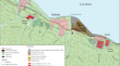
Methods of Radar Interferometry and Optical Satellite Image Processing to Study Negative Effects on the Environment (a Case Study of the Baikalsk Pulp and Paper Mill)
AbstractThe results of the study of the condition of the territory and waste deposits of the Baikalsk Pulp and Paper Mill using radar and optical...
-
Erratum to: The February 6, 2023, Earthquakes in Turkey: A Model of the Rupture Surface Based on Satellite Radar Interferometry
An Erratum to this paper has been published: https://doi.org/10.1134/S1028334X2307019X
-
Monitoring surface deformation with spaceborne radar interferometry in landslide complexes: insights from the Brienz/Brinzauls slope instability, Swiss Alps
We performed an extensive analysis of C-band SAR datasets provided by the European Space Agency (ESA) satellites ERS-1/2, Envisat ASAR, and...

-
The Potential of Satellite Interferometry for Geohazard Assessment in Cultural Heritage Sites
A continuous monitoring system of ground deformation, based on radar images acquired by ESA (European Space Agency) Sentinel-1 constellation, is...
-
Assessment of the ASAR and PALSAR Sensors Applicability for Detecting and Monitoring of Landslides in the Zagros Area (Iran) Through Differential Synthetic Aperture Radar Interferometry (DInSAR)
Lunching satellites equipped with the Synthetic Aperture Radar (SAR) sensor for interferometry applications has created a great chance to detect and...

-
Persistent scatterer interferometry (PSI) technique for road infrastructure monitoring: a case study of the roadway network of the Nile Delta (Egypt)
A dependable transportation infrastructure is an essential local resource, linking communities and facilitating economic expansion. The Nile Delta,...

-
EZ-InSAR: An easy-to-use open-source toolbox for map** ground surface deformation using satellite interferometric synthetic aperture radar
Satellite Interferometric Synthetic Aperture Radar (InSAR) is a space-borne geodetic technique that can map ground displacement at millimetre...
-
Reconstruction of Co-Seismic and Post-Seismic Processes for the February 6, 2023 Earthquake in Turkey from Data of Satellite SAR Interferometry
AbstractUsing different methods for processing SAR images from the Sentinel-1A satellite, the displacement fields were determined in the region of...

-
Monitoring of Subsidence in Berezniki City (Perm Krai) by SAR Interferometry. Method of Persistent Scatterers
AbstractThe paper presents the results of the processing of satellite radar images acquired by the TerraSAR-X satellite using the persistent...

-
Improving landslide inventories by combining satellite interferometry and landscape analysis: the case of Sierra Nevada (Southern Spain)
An updated and complete landslide inventory is the starting point for an appropriate hazard assessment. This paper presents an improvement for...

-
Satellite radar interferometry for assessing coseismic liquefaction in Portoviejo city, induced by the Mw 7.8 2016 Pedernales, Ecuador earthquake
The Portoviejo city, located in the central part of the Ecuadorian Pacific Coast (province of Manabí), was severely affected during the Pedernales Mw...

-
Prospects of utilizing the Korean satellite program for geological disaster detection and analysis
The frequency and impact of major geological disasters are increasing worldwide, highlighting the growing importance of prompt and efficient damage...
-
Monitoring of landslide displacements in Owakudani, Hakone volcano, Japan, using SAR interferometry
Owakudani (Owakuzawa Valley), the largest fumarole area in Hakone volcano, Japan, is a place where volcanic disasters occur frequently, such as the...

-
Assessment of the Risk of Landslides and Rockslides in Northern Morocco by Radar Interferometry Differential
The northern Rif is probably the region of Morocco the most affected by various types of natural hazards. Landslides and rock slides are widespread,...
-
Measurement of surface deformation related to the December 2018 Mt. Etna eruption using time-series interferometry and magma modeling for hazard zone map**
Mount Etna has erupted several times since it was first formed. Recently, Mount Etna began erupting again over 24–27 December 2018. Because it erupts...
-
Enigma of the Olyutorskii Earthquake Resolved by SAR Interferometry
The M w 7.6 Olyutorskii earthquake of April 20, 2006, struck the southern edge of the Koryak Highland, in a region of great complexity at the junction...

-

-
Monitoring activity in Mount Melbourne, Antarctica, by multi-temporal SAR interferometry based on the ICOPS algorithm
Monitoring active volcanoes is necessary to analyze their current status to pose a mitigation hazard. Mount Melbourne is an active volcano that has...