Search
Search Results
-
Use of AERONET-OC for validation of SGLI/GCOM-C products in Ariake Sea, Japan
A station of AErosol RObotic NETwork Ocean Color (AERONET-OC) has been set on the Ariake Observation Tower of Saga University on April, 2018, for...

-
Retrieval of Micro-Phytoplankton Density using Sentinel-3 and MODIS Satellite Sensors on the Eastern Algerian Coast
The spatiotemporal variability of the major phytoplankton groups, such as dinoflagellates and diatoms, provides crucial information about the...

-
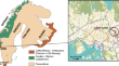
The dik-diks of Guli Waabayo: Late Pleistocene net-hunting and forager sociality in eastern Africa
Net-hunting is closely linked to organized labor and hunter-gatherer cooperation in many world regions. At the Rifle Range Site (RRS) in southern...

-
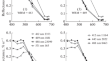
Assessment of prediction model of the CPUE of neon flying squid with different sources of remote sensing data
Accurately building the relationship between the oceanographic environment and the distribution of neon flying squid ( Ommastrephes bartramii ) is very...
-
Evaluation of temperature modifying effect of PM2.5 on respiratory mortality in high latitude monsoon area
Particulate matter (PM) has been demonstrated to be a significant risk for the onset of respiratory diseases worldwide. We used a generalized...
-
Modeling and map** sea surface gage height using satellite remote sensing data
Sea surface gage height (SSGH) data are commonly measured at sparsely deployed tidal stations while coastal resources management requires spatially...

-
Inter-annual and seasonal cycle of satellite derived sea surface salinity in the western Bay of Bengal
A spatial and temporal variation of sea surface salinity (SSS) is vital to understand the dynamics of the seasonal and inter-annual changes in the...

-
Particulate Organic Carbon (POC) Estimation and Algorithm Development in Northeast Arabian Sea Coastal Water
In situ sampling and analysis for water quality and bio-optical parameters carried out in the northeast Arabian Sea, in Diu and Daman coastal waters...

-
Use of Hyperspectral Satellite Data for Identifying Cyanobacteria in the Black and Azov Seas
AbstractIn this paper we use data from the Hyperspectral Imager for the Coastal Ocean (HICO, NASA) hyperspectral satellite sensor to identify and...

-
Detection of Coccolithophore Bloom Episodes in Algiers Bay Using Satellite and In Situ Analysis
In Algiers Bay, coccolithophore blooms of Holococcolithophora sphaeroidea species were identified from in situ observations during August 2003,...
-
Assessing the water quality dynamics in the coastal waters of Kollam (Kerala, India) using Sentinel images
Coastal waters are complex, dynamic, and sensitive, and any change in the system impacts the marine environment and life. Coastal water quality has...

-
Satellite-observed significant improvement in nearshore transparency of the Bohai Sea during pollution control
The Bohai Sea (BS) is the unique semi-closed inland sea of China, characterized by degraded water quality due to significant terrestrial pollution...
-
Effects of Mesoscale Mixing on Phytopigment Determinations in the Photic Zone from Multispectral Ocean Color Data (The Case of the Tasman Sea)
AbstractThe inconstancy of the composition of phytopigments during intensive mesoscale mixing of the photic zone of the Tasman Sea was investigated...
-
A Hybrid Methodology of Rock Support Design for Poor Ground Conditions in Hard Rock Tunnelling
The design of rock support in hard rock tunnelling is often assisted by the use of empirical engineering rock mass classification systems. This has...

-
Sea Surface Temperature and Phytoplankton Abundance as Crucial Proxies for Green Noctiluca Bloom Monitoring in the Northeastern Arabian Sea: A Case Study
Green Noctiluca scintillans ( NS G) is a mixotrophic dinoflagellate that frequently forms intense blooms in the north Indian Ocean, especially in the...

-
Atmospheric Correction Algorithms Assessment for Sentinel-2A Imagery over Inland Waters of China: Case Study, Qiandao Lake
Around 90% of the oceanic and inland waters’ reflectance registered in satellite detectors comes from the atmospheric contribution. Hence the...

-
Deck Spectroradiometer for Measuring Remote Sensing Reflectance
AbstractThe results of the development and field testing of a compact high-speed deck spectroradiometer for remote sensing reflectance measurements...

-
Spatiotemporal Variability of Cyanobacteria Blooms from Their MODIS-Based Automatic Identification
AbstractAn automatic algorithm is proposed for identifying areas of cyanobacteria (CB) blooms in the Azov Sea based on an analysis of the optical...

-
Spatial and temporal variation of water clarity in typical reservoirs in the Bei**g-Tian**-Hebei region observed by GF1-WFV satellite data
Rapidly monitoring regional water quality and the changing trend is of great practical and scientific significance, especially for the...
-
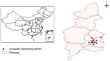
Analysis of the stabilising effect of ribs of reinforced sprayed concrete (RRS) in the Løren road tunnel
The Løren tunnel is a road tunnel at Ring road 3 in Oslo, Norway. The tunnel has a length of 915 m in rock, has two tubes with three lanes and...