Search
Search Results
-
Navigation Analysis at the Entrance to the Bypass Channel of Siarzewo Barrage
Navigation safety is the most important issue on any waterway. Plans to use the lower Vistula as an inland waterway came from the 1960s. As the first...
-
Simulation and Analysis of Back Siltation in a Navigation Channel Using MIKE 21
The channel back-siltation problem has been restricting the development of channels, and its monitoring is limited by funds and natural conditions....
-
GLONASS signal characteristics analysis and navigation performance for geostationary satellites
The utilization of the global navigation satellite system (GNSS) is becoming an attractive approach for autonomous navigation of the geostationary...

-
On-board validation of BDS-3 autonomous navigation using inter-satellite link observations
The third generation of the BeiDou navigation satellite system (BDS-3) has accomplished a complete constellation with 30 BDS-3 satellites in 2020....

-
Monitoring of equatorial plasma bubbles using aeronautical navigation system: a feasibility study
It has long been known that field-aligned irregularities within equatorial plasma bubbles (EPBs) can cause long-range propagation of radio waves in...

-
Channel Morphology and Flow Distribution between Islands in Complex Parallel-Branch Bifurcation in the Lower Lena and Their Long-Term Variations
AbstractThe first full morphological–hydrological characteristic is given to complex parallel-branch bifurcations of the lower Lena, which have...

-
Assessing Hazardous Manifestations of Horizontal Channel Deformations in Rivers of the Ob–Irtysh Basin
AbstractBank erosion is a hazardous manifestation of channel processes, which are widespread on the rivers of the Ob–Irtysh basin and pose both real...

-
Analysis of the Hydrological Regime of the Congo River in Brazzaville and Its Impact on Navigation
Our study consists of analyzing the hydrological behavior of the Congo River to detect the anomalies observed which have negatively impacted...
-
Morphological Dynamics of Mid-Channel Bars under Controlled River Regime
The study on evolutionary dynamics of Mid-Channel Bars (MCBs) under regulated-river regime is surprisingly scanty. To bridging this gap,...

-
Impacts of channel dredging on hydrodynamics and sediment dynamics in the main channels of the Jiaojiang River Estuary in China
Channel dredging in estuaries increases water depth and subsequently impacts sediment dynamics and morphology. The Jiaojiang River Estuary is dredged...
-
Advanced space rubidium atomic frequency standard for satellite navigation
NavIC (Navigation with Indian Constellation) is a regional satellite navigation system called Indian Regional Navigation Satellite System (IRNSS)....

-
Unravelling submarine channel morphology in the lower Bengal Fan through ultra-high-resolution autonomous underwater vehicle (AUV) survey
The Bengal Fan, the largest submarine fan in the world, spanning the whole Bay of Bengal resulted from the India-Asia collision event and subsequent...

-
Morphologic Adjustment of a River Reach with Groynes to Channel Bypassing
This article is focused on the investigation of the spatio-temporal variability of the Danube River reach’s vertical accretion thickness due to the...
-
Estimation of the Influence of the Dispersion and Diffraction Properties of the Ionosphere on the Transionospheric Channel Bandwidth
Abstract —A hardware and software complex for estimating the dispersion distortion bandwidth and fading coherence bandwidth in a satellite...

-
Adjustments in low-water channel geometry caused by upstream damming: an example from the **gjiang Reach, China
The flow and sediment regime entering downstream rivers can be altered remarkably owing to upstream damming, and adjustments in low-water channel...

-
Frequency design of LEO-based navigation augmentation signals for dual-band ionospheric-free ambiguity resolution
Due to the spectrum congestion of current navigation signals in the L-band, it is difficult to apply for another two proper frequencies in this band...

-
Long-term slow slip events with and without tremor activation in the Bungo Channel and Hyuganada, southwest Japan
Slow slip events (SSEs) lasting for approximately 1 year occur every 6–8 years around the Bungo Channel in the southwest Japan subduction zone. The...
-
The impact of large dams on sediment deposition and channel adjustment: a case study at the Huanghuacheng Reach in the Three Gorges Reservoir, China
Since the Three Gorges Reservoir began impoundment in 2003, drastic changes have been occurring in the Huanghuacheng (HHC) Reach, which is about...

-
GNSS position-aided delay-locked loops for accurate urban navigation
In urban environments, when GNSS signals are weakened, blocked, and interfered with by multipath, the tracking accuracy and continuity of scalar...

-
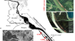
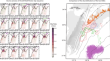
Estuarine response to storm surge and sea-level rise associated with channel deepening: a flood vulnerability assessment of southwest Louisiana, USA
This study investigates the sensitivity of the Calcasieu Lake estuarine region to channel deepening in southwest Louisiana in the USA. We test the...
