Search
Search Results
-
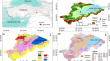
Hazard Assessment and Hazard Map** for Kuwait
Hazard maps are essential tools to aid decision makers in land-use planning, sustainable infrastructure development, and emergency preparedness....

-
Debris flow susceptibility and hazard assessment in Fushun based on hydrological response units
Fushun, located in Northeast China, is prone to debris flow disasters due to its complex topographical and geological conditions. In 2013,...

-
Seismic Hazard Maps of the Eastern Himalaya Syntaxis by Integrating the Surface Topography and Site Effects
The complex tectonic position and the long history of the devastating earthquakes with massive casualties and socio-economic damages have highlighted...

-
Evaluation of bivariate statistical and hybrid models for the preparation of flood hazard susceptibility maps in the Brahmani River Basin, India
Floods are one of the natural disasters that occur most frequently in the Brahmani River of Eastern India. Frequent floods in the area, results from...

-
A Hybrid Multi-Hazard Susceptibility Assessment Model for a Basin in Elazig Province, Türkiye
Preparation of accurate and up-to-date susceptibility maps at the regional scale is mandatory for disaster mitigation, site selection, and planning...
-
Site characterisation and probabilistic seismic hazard assessment in Tura City, Meghalaya
Tura city is situated in a seismically active area of the Western Garo Hills of Meghalaya (India) that experienced the devastating 1897 Assam...

-
Hazard and risk assessment for early phase road planning in Norway
Road construction in rugged terrain and variable, partly harsh climate is challenging. Proper assessment of natural hazards at an early planning...

-
Scenario-based tsunami hazard assessment for Northeastern Adriatic coasts
Significant tsunamis in the Northern Adriatic are rare, and only a few historical events have been reported in the literature, with sources mostly...

-
Probabilistic seismic hazard assessment framework for Uganda: a stochastic event-based modelling approach
Uganda lies between the eastern and western arms of the East African Rift System, the largest seismically active rift above sea level. With...

-
The Volcanic Hazard Maps Database: an initiative of the IAVCEI Commission on Volcanic Hazards and Risk
In this work we present the International Association of Volcanology and Chemistry of the Earth’s Interior (IAVCEI) Commission on Volcanic Hazards...

-
Deterministic tsunamigenic earthquake hazard assessment for the northern coast of Egypt based on multi-scenario approach
Egypt’s northern coast can be considered a dynamic natural system like several coastal regions worldwide. While it provides many opportunities and...

-
Co-seismic and rainfall-triggered landslide hazard susceptibility assessment for Uganda derived using fuzzy logic and geospatial modelling techniques
Uganda has suffered from many damaging landslides like the 1966 Rwenzori, 1994 Kisomoro and 2010 Bududa events. Despite escalating landslide risks...

-
On the role of digital terrain topography and land use dynamics in flood hazard assessment of urban floodplain
Flood hazard assessment of cities gained significance globally due to rise in frequency of flood events and rapid urbanisation. Uncertainties in...
-
Rainfall-seismic coupling effect induced landslide hazard assessment
Rainfall and earthquakes are the primary causes of landslides. In order to reveal the occurrence mechanisms and spatial differentiations of the...

-
Integrated hazard assessment of rockfall incidents in the Cap Aokas Cliff Region
Rock fall accidents in mountainous cliff areas have significant consequences for human life and transportation. This study aimed to evaluate the...
-
An integrated geospatial and statistical approach for flood hazard assessment
Among natural hazards and disastrous outcomes, floods have tremendous impacts on infrastructure as well as on humans. In the present study, we...

-
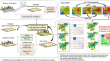
A novel method based on deep learning model for national-scale landslide hazard assessment
Landslide hazard assessment is crucial for landslide monitoring and early warning. A novel method based on deep learning model for national-scale...

-
Landslides and flood multi-hazard assessment using machine learning techniques
Saudi Arabia is affected by various types of natural hazards that affect people's lives and property. In this paper, the effects of landslides and...

-
Probabilistic assessment of seismically triggered landslide hazard for Uttarakhand (India) in the Western Himalayas
Landslides are a major cause of earthquake damage, and the ability to anticipate seismically triggered landslide displacement is critical for seismic...

-
Flood hazard assessment for the coastal urban floodplain using 1D/2D coupled hydrodynamic model
In the current study, the one-dimensional/two-dimensional (1D/2D) coupled hydrodynamic model is used for the development of flood hazard maps for the...
