Search
Search Results
-
Evaluation of NOAA/AVHRR Sea Surface Temperature at Full HRPT Resolution in the Northwest Pacific Ocean
The National Oceanic and Atmospheric Administration (NOAA) Polar Orbiting Environmental Satellites (POES) High Resolution Picture Transmission (HRPT)...
-
An Improved DDV Algorithm for the Retrieval of Aerosol Optical Depth From NOAA/AVHRR Data
Aerosol Optical Depth (AOD) is one of the important parameters to characterize the physical properties of the atmospheric aerosol, which is used to...

-
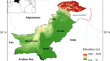
Spatiotemporal analyses of temperature and equivalent temperature and their relationship with crop health across Pakistan’s cropland
Spatiotemporal variations in temperature (T) and equivalent temperature (Te) significantly impact agricultural production across Pakistan,...
-
Assessment of Spatiotemporal Variation of Agricultural and Meteorological Drought in Gujarat (India) Using Remote Sensing and GIS
The agricultural and meteorological droughts are prominent natural hazards, and the risk associated with them has adversely affected rainfed...

-
Drought Assessment Using GIS and Remote Sensing in Jordan
Drought is an anticipated consequence of climate change with diverse impacts on humans and ecosystems. Jordan with its limited natural and water...
-
Spatial Patterns of the Primorye Current in the Northwestern East/Japan Sea on Satellite Images and Standard Sections
Spatial patterns of the Primorye Current, as a band of cold water along the coast of Primorye (northwestern East/Japan Sea), are considered on the...

-
Performance Evaluation of INSAT-3D Derived Outgoing Long Wave Radiation Over India Using Remotely Sensed Observations
This research work focuses on the comparison of Outgoing Long Wave Radiation (OLR) derived from the current operational Indian National SATellite-3D...

-
Responses of the Sea Surface Temperature and Suspended Matter Concentration to ENSO Events in the Bohai Sea
The sea surface temperature (SST) and sea surface suspended matter concentration data in the Bohai Sea were collected by multiple NOAA satellites...
-
Lessons Learned from the Updated GEWEX Cloud Assessment Database
Since the first Global Energy and Water Exchanges cloud assessment a decade ago, existing cloud property retrievals have been revised and new...

-
Pre-Processing, Quality Assurance, and Use of Global Atmospheric Motion Vector Observations in CRA
Assimilation of atmospheric motion vectors (AMVs) is important in the initialization of the atmospheric state in numerical weather prediction models,...
-
Was können wir aus den IPCC- und anderen Syntheseberichten lernen?
Ausgehend von den in den vergangenen Abschnitten skizzierten Schlüsselthemen und Fallstudien sowie den zugehörigen Forschungsergebnissen stellt sich...
-
Long Term Monitoring of Ecological Status of Major Deserts of the World
Deserts are unique ecosystems that provides suitable habitats to many floral and faunal species and that are beneficial to human beings in many ways....

-
Active Fire Monitoring of Thailand and Upper ASEAN by Earth Observation Data: Benefits, Lessons Learned, and What Still Needs to Be Known
This paper describes the history of active fire monitoring of Thailand and Upper ASEAN (Cambodia, Lao PDR, Myanmar, and Vietnam) by Earth Observation...
-
Space and time variability of meteorological drought in Syria
This study assesses the spatial and temporal characteristics (e.g., frequency, intensity, spatial extent) of meteorological drought in Syria....

-
Satellite Missions and Instruments
In this chapter, satellite missions targeted on cloud and precipitation measurements are first outlined, followed by an overview of instruments...
-
Two-Channel Algorithm for Determining the Aerosol Optical Depth over the Sea Surface Using the MSU-MR Radiometer of the Meteor-M No. 2 Satellite
AbstractIn this paper, we consider the problem of determining the aerosol optical depth above the sea surface using the data of short-wavelength...

-
Assessment of Agricultural Drought in Upper Seonath Sub-Basin of Chhattisgarh (India) Using Remote Sensing and GIS-Based Indices
Global warming threatens the hydrological cycle, resulting in parched dry season and inferable from its serious impact on profitability of downpour...

-
Unraveling the Complex Relationships Between Aerosol Optical Depth and Temperature: A Review
The relationship between aerosol optical depth (AOD) and temperature is a complex and significant aspect of climate science, impacting atmospheric...
-
Manifestation of Upwellings in the Black Sea in Multisensor Remote Sensing Data
AbstractResults of upwelling research in the Black Sea, namely in the northeastern part of the sea, near the Tendrovskaya Spit and western coast of...

-
Investigating remote sensing indices to monitor drought impacts on a local scale (case study: Fars province, Iran)
As drought occurs in different climates, assessment of drought impacts on parameters such as vegetation cover is of utmost importance. Satellite...
