Search
Search Results
-
PyLST: a remote sensing application for retrieving land surface temperature (LST) from Landsat data
Understanding land surface temperature (LST) dynamics is crucial for assessing the impacts of changes in land use and land cover (LULC) through...

-
Land use/land cover classification with Landsat-8 and Landsat-9 satellite images: a comparative analysis between forest- and agriculture-dominated landscapes using different machine learning methods
The Landsat program, which started in 1972 with Landsat-1, continues today with its newest satellite, Landsat-9, launched on 27 October 2021. The...

-
Integrating LiDAR and Landsat Images for 3D Visualization
In this work, we present a visualization tool of 3D spaces obtained from integrating Landsat and LiDAR images. The increasing necessity of...
-
Intercomparison between sentinel-1, sentinel-2, and landsat-8 on reservoir water level estimation
Remote sensing technology has made it possible for the surface water level to be updated accurately and often to prepare against water scarcity and...
-
Comparative Analysis and Implication of Hyperion Hyperspectral and Landsat-8 Multispectral Dataset in Land Classification
Remote sensing via hyperspectral imaging delivers the crucial earth’s surface information in narrow spectral bands, which may not be possible with...

-
Assessment of Surface Water Quality Based on Landsat 9 Operational Land Imager Combined with GIS and IOT
The present study's goal is to evaluate surface water quality using integrated techniques of remote sensing, geographic information systems (GIS),...
-
Spatial comparison of inland water observations from CYGNSS, MODIS, Landsat, and commercial satellite imagery
Accurate and timely inland waterbody extent and location data are foundational information to support a variety of hydrological applications and...

-
Develo** a Soil Salinity Model from Landsat 8 Satellite Bands Based on Advanced Machine Learning Algorithms
Soil salinity is a significant challenge in numerous regions across the globe, including Egypt. The potential consequences encompass negative impacts...

-
Estimating soil surface moisture by using landsat 8 and sentinel 2 satellites techniques depending on the stepwise decision tree
Estimating various parameters such as the physical parameters of the soil using remote sensing is not easy. Therefore, intelligent statistical models...
-
Water Changes and Sources of Siling Co Using Landsat and GRACE Data since 1972
The inland lakes on the Tibetan Plateau (TP) are undergoing significant changes due to their sensitivity to climate. The largest lake in Tibet,...
-
Map** and monitoring of mangrove species in Eastern Lagoon National Park, Abu Dhabi, using Landsat 8 OLI data
Mangrove species are shrubs and trees that are ecologically efficient and salt tolerant, predominantly grow in the intertidal region where land and...
-
Evaluation of Landsat 8 and Sentinel-2 vegetation indices to predict soil organic carbon using machine learning models
Soil organic carbon (SOC) stands out as a crucial indicator for assessing soil properties due to its direct impact on soil productivity. To delve...

-
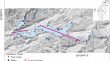
Lithological discrimination and structural lineaments extraction using Landsat 8 and ASTER data: a case study of Tiwit (Anti-Atlas, Morocco)
The present work reveals the potential of Landsat 8 and ASTER imagery in the lithological discrimination and structural lineaments extraction in the...

-
Application of Convolutional Neural Networks for Detecting Sea Ice Leads in the Laptev Sea with Landsat-8 Satellite Imagery
AbstractA method for detecting leads in the ice of the Arctic seas from satellite images of the visible range is presented. It is shown that sea ice...

-
Investigating the Effect of Relative Spectral Response on the Estimation of Atmospheric Parameters: A Case Study of Landsat 8 (OLI) and Sentinel 2 (MSI)
Accurate estimation of atmospheric parameters is crucial for accurate atmospheric correction as well as aerosol retrieval. While spectral...

-
Examining the evolution of tidal creeks in the Huanghe River delta using multi-temporal Landsat images
Coastal tidal creeks are important channels for exchanges of material and energy between sea and land, and play an important role in the ecological...
-
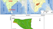
Lithological, structural, and alteration map** of uraniferous granitoid using Landsat 8, in the oriental part of the Reguibat shield, northern Mauritania
The efficacy of remote sensing techniques for mineral exploration has been proven through several geological investigations. Therefore, this study...

-
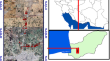
Prospecting and Map** Iron Ore within the Niger–Benue Confluence Using Landsat 8
This study used Landsat 8 (OLI/TIRS) to map iron ore deposits around the Niger–Benue River Confluence in Nigeria. Radiometric calibration was used to...

-
ArcOLITIRS: A Toolbox for Radiometric Calibration and Surface Temperature Estimation from Landsat 8 Products in ArcGIS Environment
ArcGIS, a leading geospatial software, provides a set of geoprocessing (GP) tools for image processing and raster analysis but lacks advanced image...

-
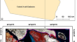
Map** lineaments using Landsat 8 OLI and SRTM data; a case study of the eastern part of the Ouarzazate Basin, Morocco
The integration of remote sensing and geographic information system (GIS) was employed in this study to delineate the structural lineaments within...