Search
Search Results
-
Real-time GNSS meteorology: a promising alternative using real-time PPP technique based on broadcast ephemerides and the open service of Galileo
Global Navigation Satellite System (GNSS) meteorology, in which the zenith total delay (ZTD) and precipitable water vapor (PWV) are retrievable from...
-
GNSS Observations at the Klimovskaya Integrated Geomagnetic Observatory
AbstractOn the territory of the Institute of Physiology of Natural Adaptations, Ural Branch, Russian Academy of Sciences (RAS) (Arkhangelsk oblast),...

-
GDPS: an open-source python-based software package for multi-GNSS data preprocessing
Global Navigation Satellite System (GNSS) data preprocessing is crucial for achieving high-precision navigation, positioning, and timing applications...

-
Precise positioning utilizing smartphone GNSS/IMU integration with the combination of Galileo high accuracy service (HAS) corrections and broadcast ephemerides
The Galileo High Accuracy Service (HAS) has undergone substantial development in recent years, offering users free access to GPS and Galileo...

-
GDDS: Python software for GNSS data download
With the rapid development of global navigation satellite system (GNSS), GNSS data products have been widely used for high-precision positioning and...
-
Cloud-based near real-time sea level monitoring using GNSS reflectometry
In addition to traditional tide gauges, the ground-based global navigation satellite system reflectometry (GNSS-R) that utilizes signal-to-noise...

-
Estimating GNSS satellite clock error to provide a new final product and real-time services
A method is introduced to directly estimate the model coefficients of global navigation satellite system (GNSS) satellite clock errors using global...
-
The JPL-GIM algorithm and products: multi-GNSS high-rate global map** of total electron content
The Jet Propulsion Laboratory (JPL) develops JPL-GIM, a software for generating global ionospheric maps (GIMs) of total electron content (TEC) using...

-
Data + pilot biases in modern GNSS signals
While traditional GNSS signals are always modulated with navigation data, various modern signals provide a distinct pilot channel without data...

-
Instrument of Choice: GNSS
This chapter serves as an in-depth exploration of the Global Navigation Satellite System (GNSS), dissecting its space, ground, and user segments. It...
-
Dynamic displacement monitoring by integrating high-rate GNSS and accelerometer: on the possibility of downsampling GNSS data at reference stations
We combine accelerometer and asynchronous high-rate GNSS data to retrieve dynamic displacements. The method adopts relative GNSS positioning with...

-
Multi-GNSS orbit combination at Wuhan University: strategy and preliminary products
Multi-GNSS orbits from the analysis centres (ACs) of the multi-GNSS Pilot Project of the International GNSS Service (IGS) are combined at Wuhan...

-
Temporal spectrum of spatial correlations between GNSS station position time series
The background noise in Global Navigation Satellite Systems (GNSS) station position time series is known to be both temporally and spatially...

-
Research of measurement accuracy using GNSS RTK method for determining geodetic coordinates of vertical network points
This article presents an analysis of the accuracy of real-time GNSS measurements. During measurements, geodetic points of Lithuanian first-order...

-
Towards Millimeter-Level Accuracy in GNSS-Based Space Geodesy: A Review of Error Budget for GNSS Precise Point Positioning
The aim of the new generation of Global Geodetic Observing System is a millimeter-level accuracy in positioning, with a crucial role to be played by...

-
A unified PDOP evaluation method for multi-GNSS with optimization grid model and temporal–spatial resolution
Evaluation for Global Navigation Satellite System (GNSS) Position Dilution Of Precision (PDOP) is generally based on a simulated global grid with a...

-
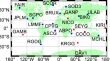
Determination of Euler pole parameters for Sundaland plate based on updated GNSS observations in Sumatra, Indonesia
To provide a precise Euler pole parameter of Sundaland plate for earthquake potential evaluation in Sumatra, Indonesia after the 2004 M9.2 Aceh...

-
Characteristics of the IGS receiver clock performance from multi-GNSS PPP solutions
Global navigation satellite system (GNSS) receivers belonging to the International GNSS Service (IGS) are equipped with different types of clocks,...

-
GNSS Software–Defined Radio
This chapter delves into the technical nuances of software-defined radio (SDR) as applied to Global Navigation Satellite Systems (GNSS). It begins by...
-
Multi-GNSS global ionosphere modeling enhanced by virtual observation stations based on IRI-2016 model
The inhomogeneous distribution of Global Navigation Satellite System (GNSS) stations results in inaccurate vertical total electron contents (VTECs)...
