Search
Search Results
-
Gradient descent fusion for gravity and magnetic data
Subsurface characterization is a crucial aspect of geophysical exploration, enabling the identification and understanding of valuable geological...

-
GravNetAdj: a MATLAB-based data processing software for gravity network adjustment
In order to realize the gravity standard using the gravity data of a specified group of stations, the gravity reference network is crucial for...

-
Gravity anomalies determined from mean sea surface model data over the Gulf of Mexico
With the improvements in the density and quality of satellite altimetry data, a high-precision and high-resolution mean sea surface model containing...
-
Regional Gravity Model of Greece Based on Satellite, Marine and Terrestrial Data
Greece is a country structured by land, several islands and sea. A regional gravity model of such a country demands the involvement of several types...

-
Joint inversion of full-tensor gravity gradiometry data based on source growing
Three-dimensional inversion based on source growing uses systematic searches. Compared with the regularization inversion, this method has lower...
-
A Dual-Layer Equivalent-Source Method for Deriving Gravity Field Vector and Gravity Tensor Components from Observed Gravity Data
Gravity survey is an effective method for determining density variations and geological structure features. In most cases, techniques for...

-
A New Combined Technique for Solving Nonlinear Gravity Problems from Planetary Topography, Gravity Field Data, and Crustal Thickness Using a Throwing off Algorithm
AbstractA new combined method for solution of nonlinear reverse gravimetry tasks is tested in this work using three data types: gravity field,...

-
Improvement of Sudan Gravity Field Using Geopotential and Altimetry Data
The gravity measurements in Sudan are sparse and few compared to the country area. The currently available measurements were conducted for the sake...
-
Gravity data fusion using wavelet transform and window weighting: a case study in the Ross Sea of Antarctica
Satellite gravity anomaly data are characterized with wide coverage and high overall normalized quality, and these data can be used in large-scale...
-
Vestiges of a lunar ilmenite layer following mantle overturn revealed by gravity data
The lunar crust and mantle formed through the crystallization of a magma ocean, culminating in a solid cumulate mantle with a layer of dense...

-
Estimation of Deep-Seated Faults Parameters from Gravity Data Using the Cuckoo Search Algorithm
Cuckoo Search Algorithm (CSA) is a nature-inspired metaheuristic optimization algorithm. The optimization algorithm was inspired by the life story of...

-
High-resolution regional gravity field modeling in data-challenging regions for the realization of geopotential-based height systems
AbstractModern height systems are based on the combination of satellite positioning and gravity field models of high resolution. However, in many...

-
Understanding the Constraints to the Correct Application of the Upward Continuation Operation in Gravity Data Processing
Analytical simulation of the gravity response due to a square prism buried at known depths has been done and the resulting data have been upward...

-
PL-geoid2021: A quasigeoid model for Poland developed using geophysical gravity data inversion technique
This paper presents the results of research and analyses related to the development of a new quasigeoid model fitted to GNSS/levelling data for the...
-
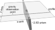
2.5D Regularized Gravity Data Inversion for the Detection of Faults in Basement Rocks
We have developed a basement fault detection technique (the so-called NVDTH) enhanced by regularized inversion of gravity data to improve the...
-
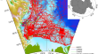
Qualitative and quantitative analysis of gravity data: structural implications in Douala–Kribi basin, Cameroon
The aim of this study is to improve the structural map of Douala–Kribi basin. For this purpose, computer tools are used to make qualitative and...

-
Global marine gravity anomalies from multi-satellite altimeter data
In this study, China’s first altimeter satellite Haiyang-2A (HY-2A) data combined observations from CryoSat-2, SARAL/AltiKa, and Jason-1&2 are used...

-
Appraisal of lineaments patterns and crustal architectures around the Owen fracture zone, Arabian Sea, using global gravity model data
This study evaluates the efficacy of GECO gravity data for geophysical studies, map** structural and tectonic features and their impact on gravity...

-
Deep learning discovery of macroscopic governing equations for viscous gravity currents from microscopic simulation data
Although deep learning has been successfully applied in a variety of science and engineering problems owing to its strong high-dimensional nonlinear...
-
Estimating the true spatial resolution of satellite altimeter-derived gravity field models with shipborne data in the South China Sea
The launch of new altimetry satellites and ongoing updates to altimetry data have continuously improved the accuracy and resolution of satellite...