Search
Search Results
-
GIS-Based Water Budget Estimation of the Kizilirmak River Basin using GLDAS-2.1 Noah and CLSM Models and Remote Sensing Observations
Satellite remote sensing products are becoming increasingly important in water resources management. Monitoring water availability and demand within...

-
Drought monitoring and evaluation using ESA CCI and GLDAS-Noah soil moisture datasets across China
Soil moisture (SM) plays a fundamental role in governing the water and energy balance at land-atmosphere interfaces and in controlling plant growth...

-
Estimation of water balance components by Noah-MP land surface model for the Neyshaboor watershed, Khorasan Razavi, Iran
The numerical modeling of the land surface can make up for the insufficient station data in terms of number, dispersion, and temporal continuity. In...

-
Monitoring the drought in Southern Africa from space-borne GNSS-R and SMAP data
Drought, a highly detrimental natural disaster, poses significant threats to both human populations, wildlife, and vegetation. Traditional methods of...

-
Using geodetic measurements derived terrestrial water storage to investigate the characteristics of drought in Yunnan, China
The use of the global navigation satellite system (GNSS) for monitoring changes in terrestrial water storage (TWS) is growing. However, the density...

-
Assessment of EnKF data assimilation of satellite-derived soil moisture over the Indian domain with the Noah land surface model
Land surface models (LSMs) are typically forced with observed precipitation and surface meteorology and hence the soil moisture estimates obtained...

-
Correlation study of the annual signal in GPS and DORIS station positions with atmospheric and hydrology loading effects
In this paper, the origin of the annual signal observed in the position time series of the GPS (Global Positioning System) and DORIS (Doppler...
-
Decomposition and reduction of WRF-modeled wintertime cold biases over the Tibetan Plateau
Land surface temperature (LST) is a critical thermal variable of the ground surface. However, accurate LST simulation is still challenging over the...

-
Monitoring Groundwater Storage Based on Satellite Gravimetry and Deep Learning
Improper abstraction of groundwater in Iran has led to an average annual subsidence rate of 15 cm/yr. The management of Iran's water resources is...

-
Assessing five highly used pesticides leaching risk under multi-layered soils using HYDRUS-1D and global datasets in the Northeast region of Thailand
Intensive use of agrochemicals and pesticides in agriculture leads to environmental degradation and toxic to human health. The present study assesses...

-
Can GRACE and CMIP6 historical data identify groundwater drought in North China Plain?
Groundwater drought is an abnormal water deficit phenomenon caused by an imbalance of the groundwater budget. The researches on groundwater drought...

-
A Diagnostic Study of the Influence of Early Spring Soil Moisture in Southeastern China on Interannual Variability of the East Asian Subtropical Summer Monsoon Onset
The effect of soil moisture (SM) on the onset of East Asian subtropical summer monsoon (EASSM) is investigated based on multiple sets of reanalysis...
-
Satellite-based estimates of declining groundwater storage in the transboundary Cambodia-Mekong River Delta Aquifer of the Lower Mekong region, Southeast Asia
The Cambodia-Mekong River Delta Aquifer, a vital transboundary aquifer in the Lower Mekong Region of Southeast Asia, faces escalating challenges due...

-
Analysis of spatio-temporal variability of groundwater storage in Ethiopia using Gravity Recovery and Climate Experiment (GRACE) data
The spatio-temporal variability of groundwater storage cannot be well understood without proper groundwater monitoring schemes. Since 2002, the...
-
Bridging the Temporal Gaps in GRACE/GRACE–FO Terrestrial Water Storage Anomalies over the Major Indian River Basins Using Deep Learning
Temporal gaps in the Gravity Recovery and Climate Experiment (GRACE) and GRACE–FO missions pose difficulties in analyzing spatiotemporal variations...

-
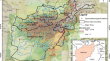
Evaluating groundwater storage variations in Afghanistan using GRACE, GLDAS, and in-situ measurements
Groundwater resources are essential for providing drinking water and irrigation in Afghanistan. However, the rising demand due to population growth...
-
Evaluation of a Stand-Alone WRF-Hydro Modeling System Using Different Rainfall Forcing Data: Case Study Over the Godavari River Basin, India
Among all the variables that relate to the water cycle, precipitation is considered the most important variable for streamflow modeling and...

-
Assessment of 30 gridded precipitation datasets over different climates on a country scale
In many regions of the globe, lack of precipitation data is one of the main factors limiting the undertaking of a wide range of environmental...
-
Modeling the impact of land use changes on the trend of monthly temperature in Basrah province, Southern Iraq
The current study aims to analyze the trend of monthly average temperature in Basrah province to understand the role of land use changes in this...

-
Assessment of groundwater level using satellite-based hydrological parameters in North-West India: A deep learning approach
Groundwater (GW) has been prominent source of freshwater for sustainable growth of agriculture, water management and urban/industrial purposes. The...
