Search
Search Results
-
Calibrating error variance and scaling global covariance function of geoid gradients for optimal determinations of gravity anomaly and gravity gradient from altimetry
With the advancements of satellite altimeter technology and data volume, the accuracy and spatial resolution of altimeter-derived marine gravity...

-
Electromagnetic Modeling Using Adaptive Grids – Error Estimation and Geometry Representation
This review paper addresses the development of numerical modeling of electromagnetic fields in geophysics with a focus on recent finite element...

-
INS-aiding information error modeling in GNSS/INS ultra-tight integration
In the ultra-tight integration system of the global navigation satellite system/ inertial navigation system (GNSS/INS), the error models of INS...

-
Single Photon Detection Technology in Underwater Wireless Optical Communication: Modulation Modes and Error Correction Coding Analysis
This study explores the application of single photon detection (SPD) technology in underwater wireless optical communication (UWOC) and analyzes the...
-
GNSS Site unmodeled error prediction based on machine learning
A number of studies have attempted to reduce the effect of observation errors on Global Navigation Satellite Systems positioning through empirical...

-
The importance of data assimilation components for initial conditions and subsequent error growth
Despite a specific data assimilation method, data assimilation (DA) in general can be decomposed into components of the prior information,...
-
Earth’s Magnetic Declination Error Influence on Wellbore Positioning in Pakistan Region and Norwegian Sea. Case Study
AbstractThe ultimate goal of petroleum industry is to perform their routine operations with minimal risks. Nevertheless, the possibilities of...

-
A Wasserstein distance-based technique for the evaluation of GNSS error characterization
The characteristics of residual errors in GNSS positioning are crucial for fault detection and integrity monitoring. Despite the wide use of the...

-
Feature-based GNSS positioning error consistency optimization for GNSS/INS integrated system
The estimated GNSS positioning error, which is commonly represented by measures such as variance or standard deviation, will determine the weight of...
-
Estimating GNSS satellite clock error to provide a new final product and real-time services
A method is introduced to directly estimate the model coefficients of global navigation satellite system (GNSS) satellite clock errors using global...
-
Single-station single-frequency GNSS cycle slip estimation with receiver clock error increment and position increment constraints
Cycle slip detection is essential for achieving centimeter-level positioning using Global Navigation Satellite Systems (GNSS). However, when dealing...

-

-
A new approach for estimating geocenter motion based on BDS-3 plane-specific orbit error correction model
High-precision geocentric coordinates (GCC) play a crucial role in geophysical research, and can be derived as a by-product of Global Navigation...

-
A novel ionospheric TEC map** function with azimuth parameters and its application to the Chinese region
The ionospheric map** function (MF) for Global Navigation Satellite System (GNSS), a mutual projection method for the slant total electron content...

-
Estimation of the groundwater recharge coefficient by minimizing the sum total error of a regional water balance
The sustainable use of groundwater resources requires that the components of a regional water balance are understood with a high degree of accuracy,...

-
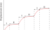
Dynamic forecast model for landslide displacement with step-like deformation by applying GRU with EMD and error correction
The displacement of a reservoir landslide mostly shows step-like deformation that is affected by the reservoir water level fluctuation and rainfall....
-
Relative humidity prediction with covariates and error correction based on SARIMA-EG-ECM model
RH is a physical quantity measuring atmospheric water vapor content. Predicting RH is of great importance in weather, climate, industrial production,...

-

-
-
Influence of adaptive inverse distance weighting method under membership function map** on the interpolation accuracy of geological boreholes
The adaptive inverse distance weighting (IDW) interpolation method shows improved computational advantages for building high-precision 3D geological...
