Search
Search Results
-
Impacts of WRF Model Domain Size on Meiyu Rainfall Forecasts over Zhejiang, China
We explore impacts of model domain size on rainfall forecasts over Zhejiang Province during the Meiyu season in this paper. The existing modeling...
-
Assessment of model time step and domain resolution of WRF model to simulate the lightning over Bihar and Rajasthan, India
The present study aims to understand the role of model Time Step (TS) and domain resolution in order to simulate the lightning event using Weather...

-
Temperature simulation by numerical modeling and feedback of geostatic data and horizontal domain resolution
The accuracy of the Weather Research and Forecasting Model (WRF) can be affected by multiple factors, including domain resolution, geostatic data,...

-
Effect of random field element size on reliability and risk assessment of soil slopes
Slope reliability analyses considering spatially variable soil properties generally necessitate a discretization of a slope region into disjoint...

-
Resource Assessment for Geothermal Energy Resources
Geothermal resource assessment has always been a tricky affair. The assessment can be done at the several stages of the development which assures the...
-
Long-Term Probabilistic Volcanic Hazard Assessment for Tephra Fallout from Neapolitan Volcanoes on Southern Italy
Somma-Vesuvius, Campi Flegrei, and Ischia are three active volcanoes in the Neapolitan Area (Italy). In this work, we evaluated the combined tephra...
-
Towards an understanding of landslide risk assessment and its economic losses: a scientometric analysis
This scientometric analysis significantly advances the understanding of landslide risk assessment and economic losses, focusing on scientometric...

-
Artificial Intelligence for Water Consumption Assessment: State of the Art Review
In recent decades, demand for freshwater resources has increased the risk of severe water stress. With the growing prevalence of artificial...
-
Landslide susceptibility map** and risk assessment using total estimated susceptibility values along NH44 in Jammu and Kashmir, Western Himalaya
Domain-specific mesoscale landslide susceptibility map** (LSM) and risk assessment was carried out along National Highway (NH44) of Jammu and...

-
A comprehensive survey of masonry bridge assessment methods: past to present
Masonry bridges, integral to transportation networks for over a century, have continuously adapted to evolving traffic demands and speeds, despite...

-
Seismicity Modeling in Tasks of Seismic Hazard Assessment
AbstractThe main disadvantages of selected elements of seismicity modeling for composing the General Seismic Zoning maps are considered in the...

-
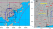
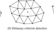
Application of Delaunay adaptive mesh refinement in flood risk assessment of multi-bridge system with short distance
To ensure bridge safety, the flood risk analysis is significant important. However, due to the small size and large number of piers in the...
-
A Multi-Domain Compression Radiative Transfer Model for the Fengyun-4 Geosynchronous Interferometric Infrared Sounder (GIIRS)
Forward radiative transfer (RT) models are essential for atmospheric applications such as remote sensing and weather and climate models, where...
-
Enhancing image processing performance with attention long short-term domain adversarial crossover orchard algorithm
The usage of digital devices has increased across the world due to global digitalization. The global digitalization concept arises due to the easy...

-
Understanding Karst Conduit Size Distribution by Numerical Speleogenesis Modeling
Large karstic conduits are rare within a rock formation, and therefore, the probability of encountering them during the construction of a tunnel is...
-
Unsteady numerical simulation of suspended load in relation to grain-size distribution
A theoretical model is presented here for the transient grain-size distribution of non-uniform sediments in suspension over erodible sediment beds...

-
A single interface for rainfall-runoff simulation and flood assessment—a case of new capability of HEC-RAS for flood assessment and management
The Hydraulic Engineering Centre–River Analysis System (HEC-RAS) is one of the most popular and widely used models for 1D, 2D and 1D/2D flood...

-
Development of a standardised framework with universal core indicators for flood resilience assessment
Understanding the flood resilience of an area is an important task for decision-makers, practitioners, and community members. However, despite the...

-
A Review of the Disaster Risk Assessment Perspectives
Researchers have explored different risk assessment approaches from the perspectives of different disciplines to capture urban risks, resulting in...
-
Landslide Susceptibility Assessment Based on Machine Learning Techniques
In this chapter, we will introduce the landslide susceptibility assessment (LSA) methods based on machine learning techniques. The economic loss or...