Search
Search Results
-
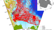
Analysis of the impact of terrain factors and data fusion methods on uncertainty in intelligent landslide detection
Current research on deep learning-based intelligent landslide detection modeling has focused primarily on improving and innovating model structures....

-
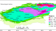
Adaptation analysis and fusion correction method of CMIP6 precipitation simulation data on the Qinghai-Tibetan Plateau
In order to obtain more accurate precipitation data and better simulate the precipitation on the Tibetan Plateau, the simulation capability of 14...
-
Gravity data fusion using wavelet transform and window weighting: a case study in the Ross Sea of Antarctica
Satellite gravity anomaly data are characterized with wide coverage and high overall normalized quality, and these data can be used in large-scale...
-
Analysis of revising multisource fusion data of high-temperature flood season weather in southern **njiang, China
To obtain a more accurate temperature distribution in areas with complex terrain, we analysed the hourly temperature product of the Land Surface Data...
-
Optimized air-ground data fusion method for mine slope modeling
Refined 3D modeling of mine slopes is pivotal for precise prediction of geological hazards. Aiming at the inadequacy of existing single modeling...
-
Waveform and resistivity data fusion imaging method based on the reflection coefficient
To achieve comprehensive analyses, the presentation of comprehensive geophysical results usually involves the use of separate imaging and the...

-
Fracture characterization based on data fusion technology and its application in rockfall hazard assessment
Rockfall has become one of the deadliest geohazards in Southwest China and how to comprehensively and effectively assess rockfall hazards is an...

-
Data level and decision level fusion of satellite multi-sensor AOD retrievals for improving PM2.5 estimations, a study on Tehran
One of the techniques for estimating the surface particle concentration with a diameter of fewer than 2.5 micrometers (PM2.5) is using aerosol...

-
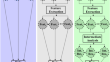
Advanced Methods of Joint Inversion and Fusion of Multiphysics Data
Different physical or geophysical methods provide information about distinctive physical properties of the objects, e.g., rock formations and...
-
Regional ionospheric model response of geomagnetic storm during March 2015 using data fusion mechanism: GPS, COSMIC RO and SWARM
The total electron content (TEC) maps are chosen as the elementary structures to provide ionospheric corrections for improving the positional...

-
Target-Oriented Fusion of Attributes in Data Level for Salt Dome Geobody Delineation in Seismic Data
Precise delineation of a salt dome’s geobody in seismic data requires intelligent integration, image fusion or combination of seismic attributes...

-
Gradient descent fusion for gravity and magnetic data
Subsurface characterization is a crucial aspect of geophysical exploration, enabling the identification and understanding of valuable geological...

-
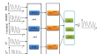
Application of the Multi-Source Data Fusion Algorithm in the Hail Identification
In this study, the canonical correlation analysis algorithm (CCA) is used to fuse the two-dimensional wind field retrieved from the single-Doppler...

-
Terrestrial carbon cycle model-data fusion: Progress and challenges
The terrestrial carbon cycle is an important component of global biogeochemical cycling and is closely related to human well-being and sustainable...
-
A Bayesian-based inspection-monitoring data fusion approach for historical buildings and its post-earthquake application to a monumental masonry palace
Many countries exposed to high levels of seismic risk, including Italy, are facing a huge challenge in promptly quantifying post-earthquake damages...
-
Performance Comparison of Image Fusion Alternatives Combining PCA with Multi-resolution Wavelet Transforms
In the situations of image fusion between the panchromatic (PAN) and the multispectral (MS) image, it is an ideal thing to properly absorb the source...

-
Hyperspectral and LiDAR data fusion in features based classification
Modern technology fusions are referred to as a significant source in remote sensing. It is one of the various sources that incorporate the use of...

-
Ensemble data-driven rainfall-runoff modeling using multi-source satellite and gauge rainfall data input fusion
Feed Forward Neural Network (FFNN), Adaptive Neuro-fuzzy Inference System (ANFIS), and Support Vector Regression (SVR) were applied for...
-
Fusion of Ground-Based and Spaceborne Radar Precipitation Based on Spatial Domain Regularization
High-quality and accurate precipitation estimations can be obtained by integrating precipitation information measures using ground-based and...
-
Improvement on the Effective Snow Cover Extraction Using Fusion Satellite Images Approach
Satellite remote sensing and optical and synthetic aperture radar (SAR) instruments can provide accurate observations of snow cover area (SCA) over...
