Search
Search Results
-
Modeling of land surface temperature (LST) in Ardabil plain using NDVI index and Bayesian neural network approach
The main purpose of this research is to evaluate the relationship between vegetation cover and land surface temperature (LST) and modeling of this...

-
Wavelet-based de-noising approach for trend analysis and coherency relation in hydrological time series (case study: Ardabil plain)
The objective of this study was to examine the impact of de-noising using the wavelet transform (WT) as a preprocessing method on the trend of...

-
Determination of global water value to improve water management in Ardabil plain, Iran
Ardabil plain is under water deficit due to its cold and dry climate in both drinking and agricultural water supply. One solution that can partially...

-
Multi-criteria evaluation of the environmental carrying capacity (ECC) of Gharesou watershed in Ardabil province to optimal utilization of watershed resource
To manage natural resources in a watershed area, it is essential to evaluate its environmental carrying capacity (ECC) and consider it for...

-
Feasibility of using UAV in surveying and 3D modeling of landslides (case study of Ardabil province)
Investigating areas geologically prone to landslides is essential in all construction projects, especially roads. The importance of this issue even...

-
A wavelet-outlier robust extreme learning machine for rainfall forecasting in Ardabil City, Iran
In this paper, the monthly long-term precipitation of the city of Ardabil from 1976 to 2020 is simulated by a modern hybrid learning machine. To this...

-
Monitoring and evaluation of effective climate parameters on the cultivation and zoning of corn agricultural crop in Iran (case study: Ardabil province)
Knowing the climate and studying the needs of crops is one of the most important factors in the production of crops. Therefore, experts based on...

-
Analyzing climate change and its effects on drought and water scarcity (case study: Ardabil, Northwestern Province of Iran, Iran)
Drought is a phenomenon that annually affects agriculture, tourism, and other areas. In recent years, a lot of research has been done on climate...
-
Evaluation of energy indices and greenhouse gas emissions in major horticultural crops and paddy crops in Tajan plain
One of the basic objectives of sustainable agriculture is the efficient use of available inputs and resources. Hence, energy use was evaluated in the...

-
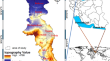
Map** land subsidence susceptibility due to groundwater decline using fuzzy pixel-based models
Land subsidence is one of the world’s natural hazard phenomena that happen by natural and human activities. Assessing the probability of land...
-
The Trend of Groundwater Level Using Threshold-Based Wavelet De-Noising Approach
AbstractThe aims of this study was to identify the groundwater level (GWL) trend and dominant periodic component of Ardabil plain (North-west of...

-
Microplastic pollution in sediments in the urban section of the Qara Su River, Iran
Microplastic pollution is an emerging threat to marine environments with potential environmental, social, economic, and health consequences and has...

-
Uncertainty of climate change impact on crop characteristics: a case study of Moghan plain in Iran
Crop yield is one of the most critical factors in the food security chain. Climate plays a crucial role in crop water productivity in rainfed and...

-
A Novel Approach Using Hybrid Fuzzy Vertex Method-MATLAB Framework Based on GMS Model for Quantifying Predictive Uncertainty Associated with Groundwater Flow and Transport Models
Identification of the uncertain parameters, which affecting on the qualitative behavior of the aquifer, and determining their effect on the...

-
Novel reliable model by integrating the adaptive neuro-fuzzy inference systems with wavelet transform and firefly algorithms for rainfall forecasting in the north of Iran
Rainfall is perhaps the most important source of drinking and agriculture water for the inhabitants of different parts of the world, particularly in...

-
Comparison of SEBAL, METRIC, and ALARM algorithms for estimating actual evapotranspiration of wheat crop
Evapotranspiration is one of the main components of water balance and its accurate estimation is of great importance in planning and optimizing water...

-
A comprehensive review of the salinity assessment in groundwater resources of Iran
The main purpose of the present research is to propose a comprehensive attitude of the salinity in groundwater resources of Iran using 116 papers in...
-
Systemic Management of Water Resources with Environmental and Climate Change Considerations
River basin management is very varied and challenging due to the competition in water consumption in different parts. Therefore, modeling water...

-
Selection of the best clustering technique in order to zone the frequency of dust storms in Iran
In this study, the frequency of sand and dust storms in 87 synoptic stations for the period of 1987–2019 has been prepared. The purpose of this...

-
Groundwater contamination vulnerability assessment using DRASTIC method, GSA, and uncertainty analysis
Groundwater is one of the most important water resources in arid and semi-arid regions, whose quality and quantity are variable. In this study, the...
