Search
Search Results
-
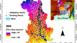
The exposure of vulnerable coastal populations to flood-induced Natech events in Hampton Roads, Virginia
Coastal flooding is increasing with rising sea levels, resulting in cascading impacts on ecological and human systems. Flood events that trigger...

-
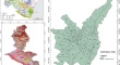
GIS-based multi-criteria decision analysis for map** flood-prone areas in Dehradun city, India
Dehradun city, capital of Uttarakhand state in India, is severely affected with increasing incidents of flooding, causing tremendous losses of life,...
-
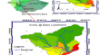
Methodological approach for map** the flood physical vulnerability index with geographical open-source data: an example in a small-middle city (Ponferrada, Spain)
To increase the resilience of communities against floods, it is necessary to develop methodologies to estimate the vulnerability. The concept of...

-
Identification of the spatio-temporal and fluvial-pluvial sources of flood inundation in the Lower Mekong Basin
Identification of the sources of the spatio-temporal information of flooding is important for flood control and understanding the water dynamic....

-
Probabilistic dam breach flood modeling: the case of Valsamiotis dam in Crete
Flooding from dam failure has disastrous downstream impacts resulting in loss of life, damage to buildings and infrastructure, and crop destruction....

-
Evaluation of flood risk at the river reach scale using Shannon’s Entropy Model: a case study of the Damodar River
The Damodar River, a monsoon-influenced river in India, is notorious for its frequent flood events, leading to its designation as the “Sorrow of...

-
New Machine Learning Ensemble for Flood Susceptibility Estimation
Floods are among the most severe natural hazard phenomena that affect people around the world. Due to this fact, the identification of zones highly...

-
Potential flood-prone area identification and map** using GIS-based multi-criteria decision-making and analytical hierarchy process in Dega Damot district, northwestern Ethiopia
Flood is one of the natural hazards that causes widespread destruction such as huge infrastructural damages, considerable economic losses, and social...

-
Flood frequency analysis with PyTOPKAPI model-simulated stream flows from Aweitu river in Jimma town, Ethiopia
Analysis of flood frequencies is critical for water resources applications. However, the majority of rivers in develo** countries like Ethiopia are...
-
Transferring flood to the dust sources of the province of Khuzestan (Southwest Iran): a multipurpose approach to water resource management
In dry and semi-dry areas, the damages incurred to the cities and villages could be decreased by guiding and distributing the flood flows. The...

-
Reconstruction of extreme flood events by performing integrated real-time and probabilistic flood modeling in the Periyar river basin, Southern India
The main purpose of this study is to mitigate the flood impact which may be caused by uncertain future extreme high rainfall-runoff events. To...

-
Improvement of flood susceptibility map** by introducing hybrid ensemble learning algorithms and high-resolution satellite imageries
Flood, a dangerous hydro-geomorphic hazard, is one of the most critically applied science research issue. The restoration and recovery are costly and...
-
Multivariate analysis of flood characteristics in Armand Watershed, Iran using vine copulas
Flood is one of the most devastating natural disasters that cause much damage every year in different world regions. The floods can be described by...

-
Development of intensity–duration–frequency curves for Herat, Afghanistan: enhancing flood risk management and implications for infrastructure and safety
Herat Province of Afghanistan has been suffering from flood damages due to inadequate infrastructure and the impacts of civil wars. There is a...

-
Flood impact assessment on agricultural and municipal areas using Sentinel-1 and 2 satellite images (case study: Kermanshah province)
Flooding stands as one of the most devastating natural occurrences, warranting immediate investigation to mitigate its destructive impact. The...

-
Flood hazard management in a multiple hazard context: a systematic review of flood hazard management during the COVID-19 pandemic in Africa
Result-oriented research can uncover hidden flood management obstacles and propose solutions that, if combined with political will, appropriate...

-
Flood hazard assessment for the coastal urban floodplain using 1D/2D coupled hydrodynamic model
In the current study, the one-dimensional/two-dimensional (1D/2D) coupled hydrodynamic model is used for the development of flood hazard maps for the...

-
Exploring the links between flood events and the COVID-19 infection cases in Romania in the new multi-hazard-prone era
The occurrence of flood events amid the COVID-19 pandemic represents a prominent part of the emerging multi-hazard landscape, as floods are one of...

-
Return Period Analysis of Major Flood Events Considering Homogeneous Regions
Extreme flood events cause huge amount of money and human resources in handling the catastrophic during and post to the disaster. In order to cope...
-
Hybrid-based approaches for the flood susceptibility prediction of Kermanshah province, Iran
This study aims at optimizing the support vector regression (SVR) model using four metaheuristic methods, Harris hawks optimization (HHO), particle...
