Search
Search Results
-
Quick and automatic detection of co-seismic landslides with multi-feature deep learning model
Co-seismic landslide detection is essential for post-disaster rescue and risk assessment after an earthquake event. However, a variety of ground...
-
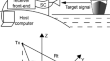
Sea target detection using the GNSS reflection signals
Global navigation satellite system (GNSS) reflection signal to form a passive radar system for sea target detection has attracted attention in recent...
-
Locating the Scope and Depth of Coal Fires Based on Magnetic and Electrical Data
Coal fires are a global environmental and social catastrophe, which deteriorate air quality, destroy the surface vegetation and soil, and pollute...

-
CSDUNet: Automatic Cloud and Shadow Detection from Satellite Images Based on Modified U-Net
Detection of clouds and shadows in remote sensing imagery is important due to its wide range of applications. There are a lot of applications in...

-
Implication of Electrical Resistivity Tomography for Precise Demarcation of Pothole Subsidence Potential Zone Over Shallow Depth Coal Mine Workings
Pothole, an undesirable catastrophic consequence, is a common phenomenon in old coal mine workings, especially at shallow depth endangering habitats...
-
Exploring Atmospheric Boundary Layer Depth Variability in Frontal Environments Over an Arid Region
Details about atmospheric boundary layer (ABL) dynamics under advection over arid regions remain unexplored. Most numerical weather prediction (NWP)...

-
MS-YOLO: integration-based multi-subnets neural network for object detection in aerial images
Aerial images is one of the most important application areas for object detection. Object detection in aerial images can be widely applied in various...

-
UGC-YOLO: Underwater Environment Object Detection Based on YOLO with a Global Context Block
With the continuous development and utilization of marine resources, the underwater target detection has gradually become a popular research topic in...
-
A new method of balanced edge detection based on curvature for gravity data
The edge detection method can be used to delineate the position of the structural boundary of the geological body, and it occupies an important...

-
Burnt coal field detection via magnetic exploration
The spontaneous combustion of coal seams is a common problem in coal-producing countries. Coal fires cause wastage of coal resources and land...

-
Optimized water depth retrieval using satellite imageries based on novel algorithms
Bathymetry is a knowledge of water depth calculation, which is of great importance in many environmental management applications. The objective of...

-
Analysis of the impact of terrain factors and data fusion methods on uncertainty in intelligent landslide detection
Current research on deep learning-based intelligent landslide detection modeling has focused primarily on improving and innovating model structures....

-
Deep Learning Techniques for Crater Detection on Lunar Surface Images from Chandrayaan-2 Satellite
Lunar exploration is pivotal in establishing a human presence on the Moon, and lunar crater detection plays a major role in this pursuit. The study...

-
Development and Application of an Online Detection Device for Well Testing Steel Wire
At present, there are not all testing methods for well testing steel wire. Non magnetic well testing steel wire can only be used to determine the...
-
Earthquake detection capacity of the Dense Oceanfloor Network system for Earthquakes and Tsunamis (DONET)
We studied the earthquake detection capacity of DONET (Dense Oceanfloor Network system for Earthquakes and Tsunamis) operating in the Nankai Trough,...

-
SFCNet: Deep Learning-based Lightweight Separable Factorized Convolution Network for Landslide Detection
It is challenging to detect landslides automatically and accurately in today’s environment, yet these are essential in preventing and minimizing...

-
Detection of geological anomalies in coal mining working faces using a scattered-wave imaging method
A concealed geological structure encountered during the excavation of a coal working face could connect the working face to high-pressure water in...

-
A Study on Ship Detection and Classification Using KOMPSAT Optical and SAR Images
The ocean, which occupies approximately 70% of the Earth’s surface, is where numerous ships navigate. Most maritime countries use various information...

-
Vision-based fatigue crack detection using global motion compensation and video feature tracking
Fatigue cracks that develop in civil infrastructure such as steel bridges due to repetitive loads pose a major threat to structural integrity....
-
Potential for tsunami detection via CCTV cameras in northeastern Toyama Prefecture, Japan, following the 2024 Noto Peninsula earthquake
This study explored closed-circuit television (CCTV) networks in northeastern Toyama Prefecture, Japan, as a new data source for tsunami detection...
