Search
Search Results
-
Application of Independent Finite Element Modeling for Estimating the Effect of Simplest Landforms on Results of Inversion of Electrical Resistivity Tomography Data (Example of a Trench with the Triangular Cross-Section)
AbstractIn solving the problems of shallow depth electrical prospecting of the daylight surface, the topography is a factor that has a significant...

-
Cultural Heritage, Landforms, and Integrated Territorial Heritage: the Close Relationship Between Tufas, Cultural Remains, and Landscape in the Upper Ebro Basin (Cantabrian Mountains, Spain)
The heritage cannot be appreciated nor entirely understood without considering the genesis and evolution of natural elements. Four places located in...

-
Flood risk on arid alluvial fans: a case study in the Joghatay Mountains, Northeast Iran
Among the common hazards related to alluvial fans, flooding is one of the most important. Nonetheless, in populated alluvial fans, not only the...
-
Geological Characteristics Analysis of the Taiyuan Limestone Gas Reservoir in Zizhou-Qingjian Area, Ordos Basin
In Zizhou-Qingjian area, Ordos Basin, the Taiyuan limestone of Early Permian has good exploration prospects. The breakthrough of well A*1H has...
-
How Can a Complex Geosite Be Enhanced? A Landscape-Scale Approach to the Deep-Seated Gravitational Slope Deformation of Pointe Leysser (Aosta Valley, NW Italy)
Complex geosites represent important georesources as components of the geoheritage of a region. Regardless, their management in terms of promotion...

-
Carbonate Dunes as Heritage Features in Mainland Portugal: A Review
Carbonate dunes are relevant coastal landforms and record sedimentary and geomorphological past conditions, frequently related to archaeological and...
-
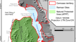
Structural–Geomorphological Conditions of the Balakovo Nuclear Power Plant Site in Terms of the Stability of Its Buildings
AbstractThe study of buried landforms during engineering–geological surveys is considered. The necessity of tracing and comprehensively studying...

-
Integrating DEM and field data to unravel the impact of bedrock topography on Late Quaternary ice flows: A case study of the Lake Mistassini area, Canada
The topography of bedrock beneath an ice sheet is one of the several factors that influence the flow of ice. It has the potential to change the...

-
Role of physical environment in groundwater contamination by arsenic in parts of West Bengal, India
AbstractHydrogeological investigations have been carried out in an area of about 777 km 2 in parts of Purba Bardhaman district and adjoining Nadia...

-
First Experience on Optically Stimulated Luminescence Dating of the Crest Relief Deposits in the Tobol-Ishim Interfluve
AbstractUsing optically stimulated luminescence (OSL) dating, the deposits of the crest (ridge) landforms in the Tobol–Ishim interfluve (southwestern...

-
Benchmarking and Map** of Soil Material Redistribution in Arable Areas
Estimation of the soil loss spatial differentiation is demanded in soil and environmental studies and land management. It appears valuable also when...
-
Characterization of a ghost-rock karst system controlled by fracture network and bedding planes in a semiarid region (NE Brazil) using ground penetrating radar (GPR)
The karstification process causes mineral dissolution and mechanical removal of carbonate rocks, creating multiscale secondary porosity that greatly...

-
Devonian-Carboniferous Carbonates in Guilin, South China: Depositional Records of Platform-Basin Complex and Major Biocrisises
Guilin is a well-known tourist city in China and abroad, marked by the breathtaking scenery of spectacular karstic landforms. These landforms...
-
The Role of the Geologic and the Geomorphologic Factors in the Formation of Some Geotourism Sites of Saudi Arabia
There are many factors that led to the formation of the geotourism sites in Saudi Arabia. Structural elements led to the formation of fantastic and...
-
Gullies as Landforms for Landslide Initiation—Examples from the Dubračina River Basin (Croatia)
This paper presents the general characteristics and spatial distribution of the gullies formed in flysch deposits in the Dubračina River Basin, and...
-
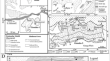
Marginal Glacial Deposits in the Southwestern Part of the Kola Peninsula
AbstractThree belts of marginal glacial deposits have been found in the southwestern part of the Kola Peninsula. They are consistent with three...
-
Geodiversity Assessment in the Midriff Islands Region of the Gulf of California (Northwest Mexico)
A concurrent qualitative-quantitative assessment of geodiversity was carried out within the Midriff Islands, a priority region within...
-
Assessment and Map** of Soils Erosion and Crop Loss by Impact of Heavy Rainfall in Northern Dry Zone of Karnataka, India
The distribution of rainfall may be adequate or inadequately affected by climate change in the arid and semi-arid regions of India. Excess rainfall...
-
An Appraisal of Geoheritage Potential: From The Delhi-Aravalli Fold- and The Himalayan Fold-Thrust Belts to the Coastal Plains of India
The concept of “geoheritage” that has emerged as a new discipline over the last few years has advocated for the preservation of geological features,...
-
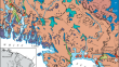
The Manifestation of Degassing in the Sedimentary Cover and Relief of the Southern Novaya Zemlya Trench (Pechora Sea)
AbstractThe results of detailed geological and geomorphological studies in the waters of the Pechora Sea using a complex of hydroacoustic methods...
