Search
Search Results
-
Soils оf Oligomesotrophic аnd Mesotrophic Bogs in the Boreal Zone of West Siberia: Possibilities of Botanical Diagnostics within the Framework of the Type of Mesotrophic Peat Soils
AbstractDespite the widespread use of the taxon “mesotrophic (transitional) peat soils” in the present-day Russian and foreign pedology, including...
-
Flood Dynamics, River Erosion, and Vulnerability in the Catchment of Dharla and Dudhkumar Rivers in Bangladesh
Bangladesh is a land of rivers, and the major part of the country consists of deltaic landform by three large river systems, the Ganges, the...
-
Structural controls on the hydrogeological functioning of a floodplain
Floodplains are often conceptualized as homogeneous sediment bodies which connect streams with their respective catchment and buffer agricultural...

-
Detecting abrupt change in land cover in the eastern Hindu Kush region using Landsat time series (1988–2020)
Land cover change in the semi-arid environment of the eastern Hindu Kush region is driven by anthropogenic activities and environmental change...
-
Accumulative Landforms in Valleys with Gas-Hydrothermal Occurrences (from the Example of Watercourses of Some Volcanic Massifs in the Kuril—Kamchatka Region)
AbstractThe formation of relief is accompanied by chemical and thermal effects within the stream valleys of geothermal zones, where manifestations of...

-
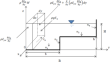
Depth averaged velocity and stage-discharge relationships in compound channels with composite roughness
The present study discusses and analyses the influence of composite roughness on the stage-discharge relationships and flow characteristics in...
-
Restored floodplains enhance denitrification compared to naturalized floodplains in agricultural streams
Predicted changes in the timing and magnitude of storms have the potential to amplify water quality challenges associated with agricultural runoff....

-
Spatial comparisons in wetland loss, mitigation, and flood hazards among watersheds in the lower St. Johns River basin, northeastern Florida, USA
Wetlands provide invaluable ecosystem services to moderate the effects of flooding. In the United States, Sect. 404 of the Clean Waters Act requires...

-
Calculation of cross flow power in prismatic compound channels using neural network
In a compound channel, there is a noticeable difference in streamwise velocity considering the flow depth difference between the main channel and its...

-
Active Flow Zones Distribution Along the Upper Vistula River Established with the Use of 1D and 2D Modelling
2D numerical modeling of hydraulic flow conditions was performed and calibrated on the Vistula River sector between Zawichost and Słupia Nadbrzeżna....
-
Property-level adaptation to pluvial flooding: An analysis of individual behaviour and risk communication material
Integrated risk management requires all stakeholders to work together proactively. Residents of floodplains can participate by implementing...
-
Estimating Annual Volga Runoff in the Late Glacial Epoch from the Size of River Paleochannels
AbstractLarge paleochannels, which are common in the floodplains and terraces of rivers in the Volga Basin, are indicators of an appreciable increase...

-
Morphodynamics and heavy metal accumulation in an artificially built near-natural river (Inde, Germany)
Heavy metals in riverine sediments threaten fluvial ecosystems worldwide. Sediment cascades transporting the compounds downstream lead to pollution...

-
Using machine learning techniques in multi-hazards assessment of Golestan National Park, Iran
Golestan National Park is one of the oldest biosphere reserves exposed to environmental hazards due to growing demand, geographical location of the...

-

-
Holistic framework for flood hazard assessment in a trans-boundary basin
The rainfall in the upper catchments associated with the hydro peaking events disturbs the regular flow regimes and is often responsible for...

-
Assessment of Carbon Stock and CO2 Production Potential for Soils of Coniferous-Broadleaved Forests
Abstract —The assessment of carbon stocks in soils of coniferous and broadleaved forests, agrocenoses, fallow lands, and floodplains has been...

-
Quartz grain surface microtextural evidence for provenance of the Quaternary aggradation red earth deposit, southern China
The Quaternary aggradation red earth (QARE) deposit in the middle reaches of the Yangtze River (MRYR) in southern China provides important evidence...
-

-
Modeling arboreal vegetation-induced friction and its influence on river flooding using a two-dimensional model
Extensive research on vegetation flow resistance at the laboratory scale has yielded numerous formulations for determining vegetation friction...
