Search
Search Results
-
AHP GIS-aided flood hazard map** and surface runoff estimation in Gurugram, India
The present study is aimed to perform flood susceptibility map** in the rapidly develo** Gurugram district of India. Major flood-triggering...

-
Flood susceptibility prediction using MaxEnt and frequency ratio modeling for Kokcha River in Afghanistan
Flooding is a natural but unavoidable disaster that occurs over time. Flooding threatens human life, property, and resources and affects regional and...

-
Hydrodynamic modelling approach for scientific assessment of flood-prone areas at basin scale
Scientific assessment of flood-prone areas under different return periods is very vital input in designing any hydraulic structures and in flood...

-
Exploring the impact of urbanization on flood characteristics with the SCS-TRITON method
Urbanization is one of the main factors altering hydrological processes. To understand the influence of urbanization on flood characteristics...

-
A systematic review with bibliometric analysis of different approaches and methodologies for undertaking flood vulnerability research
Floods have always been associated with widespread devastation and destruction since the emergence of human civilization. Assessment of vulnerability...

-
Flood risk assessment of check dams in the Wangmaogou watershed on the Loess Plateau of China
Check dams have been widely used in China’s Loess Plateau region due to their effectiveness in erosion and flood control. However, the safety and...
-
Assessing the viability of the non-monetary flood insurance market for Bangladeshi smallholder farmers
Agriculture in Bangladesh is susceptible to numerous climatic hazards, especially flooding. Smallholder farmers in the country have been losing...

-
Riverine flood map** and impact assessment using remote sensing technique: a case study of Chenab flood-2014 in Multan district, Punjab, Pakistan
The Multan district is mainly prone to riverine floods but has remained understudied. Chenab flood-2014 was the worst flood that this district...

-
Assessing flood risks in the Taquari-Antas Basin (Southeast Brazil) during the September 2023 extreme rainfall surge
This analysis delves into precipitation dynamics in the Bacia Taquari Antas region, with a focus on September 2023. Employing a multi-scale approach...

-
People-centric geo-spatial exposure and damage assessment of 2014 flood in lower Chenab Basin, upper Indus Plain in Pakistan
This study is an effort of people-centric geo-spatial exposure and damage assessment of 2014-flood in Upper Indus Plain (UIP). Community-based...

-
Earth observation technologies, policies and legislation for the coastal flood risk assessment and management: a European perspective
The aim of this contribution is to provide a brief overview of the current and future earth observation (EO) technologies that can be used to assess...

-
Delineating Flood Zones upon Employing Synthetic Aperture Data for the 2020 Flood in Bangladesh
Delineating a flood map is critical to perceive the potential risks of the event at diverse communities living both in urban and rural settings in...

-
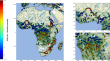
Hydrometeorological Extreme Events in Africa: The Role of Satellite Observations for Monitoring Pluvial and Fluvial Flood Risk
AbstractThis article reviews the state of the art in the use of space-borne observations for analyzing extreme rainfall and flood events in Africa....
-
Urban development assessment in flood hazard areas using integrated HEC-RAS, SCS, and FAHP models: a case study of Pardisan Settlement, Qom
Alluvial fan surfaces present unique challenges for urban development due to their susceptibility to flooding and other environmental hazards. This...

-
A new approach to flood susceptibility analysis of urbanised alluvial fans: the case of Bursa City (Türkiye)
Floods stand out as one of the most significant disasters impacting human life, causing widespread economic and social damage across the globe....

-
Urban Growth and Increasing Flood Impact in the City of Palma: A Loss of Resilience Capacity
The flood resilience capacity has been decreasing in Palma since the nineteenth century. Among the causes, the growth of the city toward coastal...
-
Fact-finding surveys on role of flood fighting in present-day Japan and future prospects: case studies of Yodo River and Yamato River
Flood mitigation efforts (flood fighting), including raising awareness among local residents, have been crucial in Japan to reduce damage during...

-
Dynamic behavior analysis of bridge pier under impact of dam-break flood in different directions
The dam-break flood formed after the collapse of a dam due to factors like earthquakes and heavy rainfall poses a significant potential threat to the...

-
Innovative control strategy for flood mitigation through a combination of barrage management on impounded rivers and polders
The partially catastrophic effects of large floods, such as the events of 2002 and 2013 in Germany and Austria for example, clearly show the...

-
Application of the analytical hierarchy process (AHP) for flood susceptibility map** using GIS techniques in Thamirabarani river basin, Srivaikundam region, Southern India
Flood susceptibility map** is required for assessing flood risk areas and develo** flood prevention techniques. The Thamirabarani river basin, a...
