Search
Search Results
-
Soil Moisture and Sea Surface Salinity Derived from Satellite-Borne Sensors
The monitoring of soil moisture and sea surface salinity over the Earth has been profoundly enhanced during the last thirteen years due to a new...

-
Integration of satellite SAR and optical acquisitions for the characterization of the Lake Sarez landslides in Tajikistan
Tajikistan is an area characterized by several lakes created after rockfalls and moraine deposits collapsed due to its geographic position on the...

-
Monitoring slope stabilization of a reactivated landslide in the Three Gorges Reservoir Region (China) with multi-source satellite SAR and optical datasets
This study presents a long-term reactivation monitoring approach using multi-source satellite SAR and optical data. It also explores the relationship...

-
On the applicability of satellite SAR interferometry to landslide hazards detection in hilly areas: a case study of Shuicheng, Guizhou in Southwest China
SAR Interferometry (InSAR) has been proven to be effective for measuring landslides deformation. However, the InSAR application of landslide map**...

-
An improved self-training network for building and road extraction in urban areas by integrating optical and radar remotely sensed data
Enhancing urban management and planning necessitates the automated and accurate extraction of features from remotely sensed images. To address the...

-
Synthetic aperture radar volcanic flow maps (SAR VFMs): a simple method for rapid identification and map** of volcanic mass flows
Volcanic mass flows, including lava, pyroclastic density currents, and lahars, account for the bulk of fatalities and infrastructure damage caused by...

-
Analysis of the Results of Geodynamic Monitoring at the Buzachi Peninsula Field, Republic of Kazakhstan
Abstract—An analysis of the results of repeated geodynamic observations at the Buzachi peninsula field are presented. Comprehensive geodynamic...

-
Combining InSAR and infrared thermography with numerical simulation to identify the unstable slope of open-pit: Qidashan case study, China
Slope failures frequently occur in open-pit mines, resulting in significant losses. Identifying the precursory displacements and triggering factors...

-
Multiple Signal Classification Algorithm Combined with Volume Reflectivity Models to Improve Accuracy of the Estimated Vegetation Height in Synthetic Aperture Radar Tomography
The aim of this paper lies in improving the accuracy of multiple signal classification (MUSIC) inversion in Synthetic Aperture Radar Tomography...

-
New Model of the Rupture Surface of the Mw = 7.8 Near Islands Aleutian Earthquake of July 17, 2017 Based on SAR Interferometry
Abstract —A new model of the rupture surface of the M w = 7.8 Near Islands Aleutian earthquake that occurred on July 17, 2017 in the region of the...

-
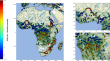
Hydrometeorological Extreme Events in Africa: The Role of Satellite Observations for Monitoring Pluvial and Fluvial Flood Risk
AbstractThis article reviews the state of the art in the use of space-borne observations for analyzing extreme rainfall and flood events in Africa....
-
Surface Deformation Monitoring from SAR Interferometry for Seismic Hazard Assessment Around Major Active Faults: Case of Zemmouri Earthquake (Algeria)
In seismogenic zones, geodetic campaigns are usually used to monitor the ground deformation. Nowadays, satellite imaging became a powerful tool to...
-
Monitoring land subsidence with the combination of persistent scatterer interferometry techniques and distributed fiber optic sensing techniques: a case study in Suzhou, China
Land subsidence is a global geo-hazard caused by various natural and human factors, and it directly threatens the safety of the environment and...

-
Forest Aboveground Biomass and Forest Height Estimation Over a Sub-tropical Forest Using Machine Learning Algorithm and Synthetic Aperture Radar Data
Forest aboveground biomass (AGB) is a key measurement in studying terrestrial carbon storage, carbon cycle, and climate change. Machine learning...
-
Widespread fracture movements during a volcano-tectonic unrest: the Reykjanes Peninsula, Iceland, from 2019–2021 TerraSAR-X interferometry
Tectonic controls on dyke emplacements, eruption dynamics and locations have been observed in multiple volcanic areas worldwide. Map** of active...

-
The MOCAST+ Study on a Quantum Gradiometry Satellite Mission with Atomic Clocks
In the past twenty years, satellite gravimetry missions have successfully provided data for the determination of the Earth static gravity field...

-
Multidimensional displacement analysis of Semeru Volcano, Indonesia following December 2021 eruption from multitrack InSAR observation
Mount Semeru, one of the world’s most active volcanoes, experiences frequent eruptions and at least one significant eruption annually. Traditional...

-
The Project of Parco Archeologico Del Colosseo and the Italian Network of Archaeological Parks: From Satellite Monitoring to Conservation and Preventive Maintenance Policies
The monitoring projectof the Parco archeologico del Colosseo was inspired by the need to build up a system of protection and conservation, based on...
-
The role of long-term preparatory factors in mass rock creep deforming slopes: insights from the Zagros Mts. belt (Iran)
The long-term evolution of slopes affected by Mass Rock Creep deformations is controlled by both time-invariant predisposing factors, such as the...

-
On the Use of Interferometric Synthetic Aperture Radar Data for Monitoring and Forecasting Natural Hazards
Recent advances in satellite technologies, statistical and mathematical models, and computational resources have paved the way for operational use of...
