Search
Search Results
-
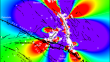
Modeling and Prediction of Aftershock Activity
We provide an overview of the basic models of the aftershock processes and advanced methods used to predict postseismic hazard. We consider both the...
-
NUIST ESM v3 Data Submission to CMIP6
This paper introduces the experimental designs and outputs of the Diagnostic, Evaluation and Characterization of Klima (DECK), historical, Scenario...
-
Seamount age prediction machine learning model based on multiple geophysical observables: methods and applications in the Pacific Ocean
Seamount ages are important for understanding crust-mantle interactions and exploring sea bottom ore resources. Rock sampling and laboratory...

-
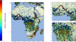
Hydrometeorological Extreme Events in Africa: The Role of Satellite Observations for Monitoring Pluvial and Fluvial Flood Risk
AbstractThis article reviews the state of the art in the use of space-borne observations for analyzing extreme rainfall and flood events in Africa....
-
Three-dimensional thermo-rheological structure of the lithosphere in the North China Craton determined by integrating multiple observations: Implications for the formation of rifts
The lithosphere of the North China Craton (NCC) has experienced significant destruction and deformation since the Mesozoic, a notable feature of...
-
Fractal Hierarchies of Dissipative Structures—Cellular Standing Internal Gravitational Waves in the Earth and Methods for Their Detection
The principal undertaking of the methods described in this work is to reveal multi-ordinal structures of gravitational instability—or dissipative...
-
Aliasing of ocean tides in satellite gravimetry: a two-step mechanism
Ocean tide aliasing is one of the largest error sources in satellite gravimetry. Despite its importance, the aliasing mechanism of ocean tides in...

-
FIO-ESM v2.0 Outputs for the CMIP6 Global Monsoons Model Intercomparison Project Experiments
Three tiers of experiments in the Global Monsoons Model Intercomparison Project (GMMIP), one of the endorsed model intercomparison projects of phase...
-
Residual terrain modelling (RTM) in terms of the cap-modified spectral technique: RTM from a new perspective
We present two novel approaches to residual terrain modelling (RTM), one of which is practical and the other rather theoretical. The first provides a...

-
Mediterranean Surface Geostrophic Circulation from Satellite Gravity and Altimetry Observations
We present a data-based approach to study the mean and the climatology of the surface geostrophic currents (SGC) for the Mediterranean Sea, using...
-
CAS-ESM2.0 Model Datasets for the CMIP6 Flux-Anomaly-Forced Model Intercomparison Project (FAFMIP)
The second version of the Chinese Academy of Sciences Earth System Model (CAS-ESM2.0) is participating in the Flux-Anomaly-Forced Model...
-
FGOALS-g3 Model Datasets for CMIP6 Flux-Anomaly-Forced Model Intercomparison Project
The Flux-Anomaly-Forced Model Intercomparison Project (FAFMIP) is an endorsed Model Intercomparison Project in phase 6 of the Coupled Model...
-
Study of coexisting upstream solitary wave packet and downstream wakes induced by Diaoyu Dao and its affiliated islands detected by satellite sun glitter
Taking the advantage of sun glitter (SG) observed from high-resolution satellites Gaofen-1 (GF-1) and Gaofen-6 (GF-6), a new method named Shield and...
-
Preliminary Investigations
In this chapter you will learn which investigations are necessary to understand the physico-chemical conditions of your mine water. This begins with...
-
Trace-Norm Regularized Multi-Task Learning for Sea State Bias Estimation
Sea state bias (SSB) is an important component of errors for the radar altimeter measurements of sea surface height (SSH). However, existing SSB...
-
Measurement analyses and evaluations of sea-level heights using the HY-2A satellite’s radar altimeter
The HY-2A satellite is China’s first independent oceanic dynamic environmental satellite, and has been operating continuously for more than six...
-
LICOM Model Datasets for the CMIP6 Ocean Model Intercomparison Project
The datasets of two Ocean Model Intercomparison Project (OMIP) simulation experiments from the LASG/IAP Climate Ocean Model, version 3 (LICOM3),...
-
Formulation of Determining the Gravity Potential Difference Using Ultra-High Precise Clocks via Optical Fiber Frequency Transfer Technique
Based on gravity frequency shift effect predicted by general relativity theory, this study discusses an approach for determining the gravity...
-
The crustal nature of the northern Mozambique Ridge, Southwest Indian Ocean
The Mozambique Ridge (MOZR) is one of the basement high structures located in the Southwest Indian Ocean, parallel to the Southeast African...
-
Topographic effects up to gravitational curvatures of tesseroids: A case study in China
Topographic effects on gravity field modeling are important for geodesy, geophysics and related geosciences. In this study we evaluate the...