Search
Search Results
-
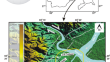
Integrated geophysical and hydrogeochemical characterization of groundwater vulnerability conditions in part of Ikom-Mamfe Embayment, southeastern Nigeria
The shallow groundwater resource within the Ikom-Mamfe Embayment has been under serious threats from anthropogenic contaminants, carbonate and...

-
Hydrogeological, geophysical, geochemical and statistical integrated techniques to assess a multilayered groundwater aquifer system in an arid region: the case of the Sbeitla aquifers in Central Tunisia
This study focuses on the hydrogeological conditions and the hydrodynamic process controlling the sandy Miocene aquifer system in the Sbeitla basin,...

-
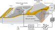
Integrated application of geophysical methods in Earth dam monitoring
Given the mounting apprehension surrounding the recurrence of incidents involving accidents and the failure of earthen dams in the past two decades,...

-
A review of open software resources in python for electrical resistivity modelling
Geophysical modelling performs to obtain subsurface structures in agreement with measured data. Freeware algorithms for geoelectrical data inversion...

-
Understanding the quality and potential of groundwater for human purposes and peat fire disaster mitigation
Issues related to groundwater sources in peat coastal areas are very complex. These include sea water intrusion and the quality of the groundwater...

-
Two-dimensional interpretation of audio-magnetotelluric data around the epicenter distribution of the 2016 Gyeongju earthquake (ML 5.8), Korea
On September 12, 2016, an M L 5.8 earthquake occurred near Gyeongju City in the southeastern part of the Korean peninsula. Two representative major...
-
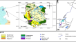
Salinity distribution in agricultural land by geophysical, hydrochemical and geostatistical approaches: a pilot area located in Qelabshowah–Belqas, East Nile Delta region, Egypt
The study area is situated in the Qelabshowah–Belqas region, known for its Quaternary deposits. This research aims to demonstrate the two-dimensional...

-
Drying-Up of a Natural Spring for Ensuring Stability of an Artificial Slope: Is It Sustainable Development?
Near a small city of the Belgian ‘Ardennes’ (East of Belgium), modification of a natural slope for extension of industrial activities has required an...
-
Delineation of lineaments for groundwater prospecting in hard rocks: inferences from remote sensing and geophysical data
Egypt is grappling with water scarcity challenges, which are exacerbated by extensive urban development in arid coastal regions with rugged terrain....

-
Multidisciplinary non-invasive investigations to develop a hydrogeological conceptual model supporting slope kinematics at Fontana Cornia landslide, Northern Apennines, Italy
A multidisciplinary approach focusing on the integration of diverse and non-invasive investigations is presented to define the hydrogeological...

-
Processing of electrical resistivity tomography data using convolutional neural network in ERT-NET architectures
Electrical resistivity tomography (ERT) inversion has emerged as an effective method for predicting resistivity in complex geological structures. In...

-
Geoelectrical investigation of groundwater potential and vulnerability of Oraifite, Anambra State, Nigeria
Electrical resistivity survey employing vertical electrical sounding was carried out in Oraifite, Southeastern Nigeria, involving a total of twenty...

-
Springs of Pasighat, a valuable resource for the community: A hydrogeological study carried out using geoelectrical resistivity technique
AbstractMany springs occur in and around Pasighat. Eight major springs of the area were considered for the study. These springs are Dimple type,...
-
A linked geomorphological and geophysical modelling methodology applied to an active landslide
Moisture-induced landslides are a global geohazard; mitigating the risk posed by landslides requires an understanding of the hydrological and...

-
A Review on Applications of Time-Lapse Electrical Resistivity Tomography Over the Last 30 Years : Perspectives for Mining Waste Monitoring
Mining operations generate large amounts of wastes which are usually stored into large-scale storage facilities which pose major environmental...
-
Combined geophysical and geochemical approaches to understand groundwater salinization processes in Sminja aquifer, northeast of Tunisia
An integrated geological, hydrochemical, and geoelectrical investigation of groundwater occurrence in Sminja plain, Zaghouan prefecture (northeast of...
-
A Straightforward Experimental Fact Demonstrating the Physical Interconnection of a SES Activity with Seismicity
Around 2 months before the volcanic-seismic swarm activity in 2000 in the Izu Island region, JapanJapan, Uyeda Seiya Uyedaand coworkers found...
-
Estimation of hydraulic parameters in a hard rock aquifer using integrated surface geoelectrical method and pum** test data in southeast Guangdong, China
Estimation of hydraulic parameters is important for the prediction of the future availability of groundwater reserves. Conventionally, pum** tests...
-
Delineation of a fractured granite aquifer in the Alwadeen area, Southwest Saudi Arabia using a geoelectrical resistivity survey
In most areas of the Arabian Shield, the local people meet their water needs through shallow dug wells in fractured basement rocks where groundwater...

-
Electrical resistivity imaging and geographical information systems investigations of Otofure and Ikhueniro Dumpsites: a case study from Edo State, South-South, Nigeria
Geoelectrical resistivity imaging (GRI) and geographical information systems (GIS) were integrated in this study to investigate leachate plumes...
