Search
Search Results
-
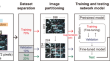
Improvement of Best First Decision Trees Using Bagging and Dagging Ensembles for Flood Probability Map**
Development of zoning and flood-forecasting models is essential for making optimal management decisions before and after floods. The Komijan...

-
FlowDIR: a MATLAB tool for rapidly and probabilistically forecasting the travel directions of volcanic flows
We present FlowDIR, a MATLAB tool that rapidly and objectively quantifies future travel direction probabilities for topographically controlled...

-
Spatial risk occurrence of extreme precipitation in China under historical and future scenarios
In recent years, extreme precipitation events have shown a significant increasing trend in both intensity and amount. Therefore, it is urgent to...

-
Optimized Hot Spot and Directional Distribution Analyses Characterize the Spatiotemporal Variation of Large Wildfires in Washington, USA, 1970−2020
Spatiotemporal analysis of fire activity is vital for determining why wildfires occur where they do, assessing wildfire risks, and develo** locally...

-
Stream sediment pollution: a compositional baseline assessment
A high concentration of potentially toxic elements (PTEs) can affect ecosystem health in many ways. It is therefore essential that spatial trends in...

-
Probabilistic projection of extreme precipitation changes over Iran by the CMIP6 multi-model ensemble
Based on the historical (period of 1990–2014) spatial and temporal ranking, a future projection of four extreme precipitation indices over Iran is...

-
Anthropogenic activities amplify wildfire occurrence in the Zagros eco-region of western Iran
The aim of this study was to improve our understanding of factors that affect the spatial distribution of wildfire occurrences at the regional scale....

-
BHARAT: a MADM approach to prioritizing the best performing EPS in a semi-arid river basin
The comparison of the discrete and finite set of predefined alternatives requires a simple, effective, and reliable Multi-Attribute Decision-Making...

-
Characterization of Seismic Source Zones in the Gulf of Aden Region
The Gulf of Aden is one of the active tectonic elements encompassing the Arabian Plate, representing a potential hazard for the southern parts of...

-
The Magnitude Threshold and Missing and Pseudo Links in Markov Chains
A crisp step function is not an adequate threshold for studies of Markovian occurrence of large earthquakes, because it can lead to missing or pseudo...

-
Classification of igneous rocks from petrographic thin section images using convolutional neural network
Rock classification from petrographic thin section analysis often requires expertise in mineralogy. This study developed a deep learning approach...
-
The influence of future weather pattern changes and projected sea-level rise on coastal flood impacts around the UK
When local extreme water levels surpass defences, the consequences can be devastating. We assess the importance of sea-level rise and future weather...
-
Validation of CHIRPS satellite-based precipitation data against the in situ observations using the Copula method: a case study of Kosar Dam basin, Iran
The present study compares the daily and monthly precipitation estimates of the CHIRPS satellite data with the in situ measurements at four stations...

-
Chaotic analysis of daily runoff time series using dynamic, metric, and topological approaches
The main goal of this work is summed up in a univariate chaotic analysis of the runoff series using a topological approach. As such, nineteen series...

-
MSC-1DCNN-based homogeneous slope stability state prediction method integrated with empirical data
The mechanism of slope stability prediction is formulated based on its material, geometrical and environmental situation, and slope stability...
-
Beyond the local climate change uplift – The importance of changes in spatial structure on future fluvial flood risk in Great Britain
Widespread spatially coherent flood events can cause severe damage and disruption. Climate change has the potential to change the severity and...

-
Delineation of hydrothermal alteration zones associated with mineral deposits, using remote sensing and airborne geophysics data. A case study: El-Bakriya area, Central Eastern Desert, Egypt
El-Bakriya area is situated in the Central Eastern Desert of Egypt. It includes several mineral occurrences and/or deposits. Data from remote sensing...

-
A novel approach for assessment of seismic induced liquefaction susceptibility of soil
Liquefaction is one of the natural hazards that occurs due to earthquakes and has a significant impact on the loss of human lives and various civil...

-
Numerical Simulation and Application of Slope Stochastic Seismic Response Analysis
Finite element method is taken to carry out slope stochastic dynamic reliability analysis. According to the theoretical framework of slope stochastic...
-
Comparison of Seismic Hazard Assessments Obtained with the Probabilistic and Probabilistic-Deterministic Approaches for the Territory of Uzbekistan
AbstractThe study compares seismic hazard assessments of the territory of Uzbekistan, obtained with the same input parameters, but using different...
