
Abstract
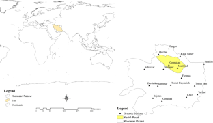
Flood early warning requires rainfall data with a high temporal and spatial resolution for flood risk analysis to simulate flood dynamics in all small and large basins. However, such high-quality data are still very scarce in many develo** countries. In this research, in order to identify the best and most up-to-date rainfall estimation tools for early flood forecasting in arid and semi-arid regions, the northeastern region of Iran with 17 meteorological stations and four rainfall events was investigated. The rainfall products of satellites (Precipitation Estimation from Remotely Sensed Information using Artificial Neural Networks-Climate Data Record, Global Satellite Map** of Precipitation, Climate Hazards Group InfraRed Precipitation with Station, European Reanalysis (ERA5), Global Precipitation Measurement) along with the most widely used microphysical schemes of Weather Research and Forecasting (WRF) model (Purdue-Lin (Lin), WRF Single-Moment class 3, 6, and WRF Double-Moment class 6. were used for rainfall modeling. The efficiency of each of these models to forecasting the amount of rainfall was verified by four methods: Threat Scores (TS), False Alarm Ratio, Hit Rate (H), and False Alarm (F). Analysis of research findings showed that the WRF meteorological model has better accuracy in rainfall modeling for the next 24 h. In this model, Lin's microphysical scheme has the highest accuracy, and its threat score (TS) quantity is up to 98% efficient in some stations. The best accuracy of satellite products for estimating the amount of rainfall is up to 50%. This accuracy value is related to the satellite product (ERA5). In this method, an 18 km distance from the ground station is the best distance for setting up the space station, which is used for input to hydrological/hydraulic models. Based on the results of this research, by using the connection of the WRF model with hydrology/hydraulic models, it is possible to predict and simulate rainfall-runoff up to 72 h before its occurrence. Also, by using these space stations, the amount of rainfall is estimated for the entire area of the basin and an early flood warning is issued.


Data and material availability
Not applicable.
References
Adhikary SK, Yilmaz AG, Muttil N (2015) Optimal design of rain gauge network in the Middle Yarra River catchment, Australia. Hydrol Process 29(11):2582–2599
Agarwal A, Marwan N, Maheswaran R, Ozturk U, Kurths J, Merz B (2020) Optimal design of hydrometric station networks based on complex network analysis. Hydrol Earth Syst Sci 24(5):2235–2251
Aminyavari S, Saghafian B, Sharifi E (2019) Assessment of precipitation estimation from the NWP models and satellite products for the spring 2019 severe floods in Iran. Remote Sens 11(23):2741
Archer CL, Wu S, Ma Y, Jiménez PA (2020) Two corrections for turbulent kinetic energy generated by wind farms in the WRF model. Mon Weather Rev 148(12):4823–4835
Ayanwale OA, Alabi O (2017) Ground validation of GPM IMERG and TRMM 3B42V7 rainfall products over Nigerian eLightning. Paper presented at the AGU Fall Meeting 2019
Azamirad M, Esmaili K (2018) Investigation flooding potential in the Kashafrud watershed, Mashhad the method SCS and GIS. J Watershed Manag Res 9(17):26–38
Belabid N, Zhao F, Brocca L, Huang Y, Tan Y (2019) Near-real-time flood forecasting based on satellite precipitation products. Remote Sens 11(3):252
Benkirane M, Laftouhi N-E, Khabba S, Hera- Á (2022) Hydro statistical assessment of TRMM and GPM precipitation products against ground precipitation over a Mediterranean mountainous watershed (in the Moroccan high atlas). Appl Sci 12(16):8309
Boroujeni SMH (2019) Post disaster needs assessment (PDNA). J Disaster Emerg Res 2(2):124–125
Cao Q, Mehran A, Lettenmaier DP, Mass C, Johnson N (2015) The utility of satellite precipitation products for hydrologic prediction in topographically complex regions: the Chehalis River Basin, WA as a case study. Paper presented at the AGU Fall Meeting Abstracts
Chao L, Zhang K, Yang Z-L, Wang J, Lin P, Liang J, Gu Z (2021) Improving flood simulation capability of the WRF-Hydro-RAPID model using a multi-source precipitation merging method. J Hydrol 592:125814
Chezgi J, Soheili E (2021) Application of TOPSIS and VIKOR decision making models in site selection of flood spreading projects in arid and semi-arid region. Desert Manag 8(16):169–182
Cloke H, Pappenberger F (2009) Ensemble flood forecasting: a review. J Hydrol 375(3–4):613–626
Cossu F, Hocke K (2014) Influence of microphysical schemes on atmospheric water in the weather research and forecasting model. Geosci Model Dev 7(1):147–160
Council AW (2009) Vulnerability of arid and semi-arid regions to climate change—impacts and adaptive strategies. Paper presented at the Perspective Document for the 5th World Water Forum, World Water Council, Marseille, Co-Operative Programme on Water and Climate (CPWC)
DeVries B, Huang C, Armston J, Huang W, Jones JW, Lang MW (2020) Rapid and robust monitoring of flood events using sentinel-1 and Landsat data on the google earth engine. Remote Sens Environ 240:111664
Dinku T, Funk C, Peterson P, Maidment R, Tadesse T, Gadain H, Ceccato P (2018) Validation of the CHIRPS satellite rainfall estimates over eastern Africa. Q J R Meteorol Soc 144:292–312
El Khalki EM, Tramblay Y, Amengual A, Homar V, Romero R, Saidi MEM, Alaouri M (2020) Validation of the AROME, ALADIN and WRF meteorological models for flood forecasting in Morocco. Water 12(2):437
ESCAP U (2019) Build a bridge on flood risk management: South-South and regional cooperation for flood risk management in the Islamic Republic of Iran
Falck A, Tomasella J, Papa F (2021) Assessing the potential of upcoming satellite altimeter missions in operational flood forecasting systems. Remote Sens 13(21):4459
Gao F, Zhang Y, Chen Q, Wang P, Yang H, Yao Y, Cai W (2018) Comparison of two long-term and high-resolution satellite precipitation datasets in **njiang, China. Atmos Res 212:150–157
Gorelick N, Hancher M, Dixon M, Ilyushchenko S, Thau D, Moore R (2017) Google earth engine: planetary-scale geospatial analysis for everyone. Remote Sens Environ 202:18–27
Guntu RK, Yeditha PK, Rathinasamy M, Perc M, Marwan N, Kurths J (2020) Wavelet entropy-based evaluation of intrinsic predictability of time series. Chaos: interdiscip J Nonlinear Sci 30(3):033117
Guo Q, Yang J, Wei C, Chen B, Wang X, Han C (2021) Spectrum calibration of the first hyperspectral infrared measurements from a geostationary platform: method and preliminary assessment. Q J R Meteorol Soc 147(736):1562–1583
Hasan MA, Islam A (2018) Evaluation of microphysics and cumulus schemes of WRF for forecasting of heavy monsoon rainfall over the southeastern hilly region of Bangladesh. Pure Appl Geophys 175(12):4537–4566
Hong Y, Gochis D, Cheng J-T, Hsu K-L, Sorooshian S (2007) Evaluation of PERSIANN-CCS rainfall measurement using the NAME event rain gauge network. J Hydrometeorol 8(3):469–482
Hong S-Y, Lim K-SS, Lee Y-H, Ha J-C, Kim H-W, Ham S-J, Dudhia J (2010) Evaluation of the WRF double-moment 6-class microphysics scheme for precipitating convection. Adv Meteorol. https://doi.org/10.1155/2010/707253
Hou S (2018) How does the evaluation of GPM IMERG rainfall product depend on gauge density and rainfall intensity? Paper presented at the AGU Fall Meeting Abstracts
Hu L, Nikolopoulos EI, Marra F, Morin E, Marani M, Anagnostou EN (2020) Evaluation of MEVD-based precipitation frequency analyses from quasi-global precipitation datasets against dense rain gauge networks. J Hydrol 590:125564
Jang S, Lim K-SS, Ko J, Kim K, Lee G, Cho S-J, Lee Y-H (2021) Revision of WDM7 microphysics scheme and evaluation for precipitating convection over the Korean Peninsula. Remote Sens 13(19):3860
Jung Y, Kim H, Baik J, Choi M (2014) Rain-gauge network evaluations using spatiotemporal correlation structure for semi-mountainous regions. TAO Terr, Atmos Ocean Sci 25(2):267
Kostarev S, Vetrov A (2018) Quality of precipitation prediction by the NWP model WRF-ARW with preliminary data assimilation. Paper presented at the IOP conference series: earth and environmental science
Krajewski W, Smith JA (2002) Radar hydrology: rainfall estimation. Adv Water Resour 25(8–12):1387–1394
Kreklow J, Tetzlaff B, Kuhnt G, Burkhard B (2019) A rainfall data intercomparison dataset of RADKLIM, RADOLAN, and rain gauge data for Germany. Data 4(3):118
Kumar L, Mutanga O (2018) Google earth engine applications since inception: usage, trends, and potential. Remote Sens 10(10):1509
Le Mire V, Boulanger X, Castanet L, Féral L (2023) Prediction of 3 years of annual rain attenuation statistics at Ka-band in French Guiana using the numerical weather prediction model WRF. Radio Sci 58(6):1–10
Li Y, Grimaldi S, Walker JP, Pauwels VR (2016) Application of remote sensing data to constrain operational rainfall-driven flood forecasting: a review. Remote Sens 8(6):456
Li H, Zhou Y, Wang X, Zhou X, Zhang H, Sodoudi S (2019) Quantifying urban heat island intensity and its physical mechanism using WRF/UCM. Sci Total Environ 650:3110–3119
Liu J, Bray M, Han D (2012) Sensitivity of the Weather Research and Forecasting (WRF) model to downscaling ratios and storm types in rainfall simulation. Hydrol Process 26(20):3012–3031
Liu YC, Zhao K, Liu Y, Yin XL (2018) Analysis of the impact of precipitation and temperature on the streamflow of the Ürümqi River, Tianshan Mountain, China. Paper presented at the IOP conference series: earth and environmental science
Lowrey MRK, Yang Z-L (2008) Assessing the capability of a regional-scale weather model to simulate extreme precipitation patterns and flooding in central Texas. Weather Forecast 23(6):1102–1126
Lu Q, Hu J, Wu C, Qi C, Wu S, Xu N (2020) Monitoring the performance of the Fengyun satellite instruments using radiative transfer models and NWP fields. J Quant Spectrosc Radiat Transfer 255:107239
Maggioni E, Manzoni T, Perotto A, Spada F, Borroni A, Giurato M, Salerno R (2023) WRF data assimilation of weather stations and lightning data for a convective event in northern Italy. Bull Atmos Sci Technol 4(1):8
Mane D, Chandrasekar A (2022) Evaluation of a stand-alone WRF-hydro modeling system using different rainfall forcing data: case study over the Godavari river basin, India. Pure Appl Geophys. https://doi.org/10.1007/s00024-022-03136-3
Massari C, Camici S, Ciabatta L, Brocca L (2018) Exploiting satellite-based surface soil moisture for flood forecasting in the Mediterranean area: state update versus rainfall correction. Remote Sens 10(2):292
Mayer MJ, Yang D (2022) Calibration of deterministic NWP forecasts and its impact on verification. Int J Forecasting. 39(2):981–991
Mohammadiha A, Memarian M, Azadi M, Parvari R (2012) Verification of WRF Model forecatings for content of precipitable water and precipitation with the RADAR data. Thesis submitted For the degree of M.Sc, pp 1–160
Moishin M, Deo RC, Prasad R, Raj N, Abdulla S (2021) Designing deep-based learning flood forecast model with ConvLSTM hybrid algorithm. IEEE Access 9:50982–50993
Moradkhani H, DeChant CM, Sorooshian S (2012) Evolution of ensemble data assimilation for uncertainty quantification using the particle filter-Markov chain Monte Carlo method. Water Resour Res. https://doi.org/10.1029/2012WR012144
Nabinejad S, Schüttrumpf H (2023) Flood risk management in arid and semi-arid areas: a comprehensive review of challenges, needs, and opportunities. Water 15(17):3113
Nasrollahi N, AghaKouchak A, Li J, Gao X, Hsu K, Sorooshian S (2012) Assessing the impacts of different WRF precipitation physics in hurricane simulations. Weather Forecast 27(4):1003–1016
Nikolopoulos EI (2010) Flash floods: understanding the runoff generation processes and the use of satellite-rainfall in hydrologic simulations: University of Connecticut
Pan S, Xu Y-P, Gu H, Bai Z, Xuan W (2021) Temporary dependency of parameter sensitivity for different flood types. Hydrol Res 52(5):990–1014
Putthividhya A, Tanaka K (2012) Optimal rain gauge network design and spatial precipitation map** based on geostatistical analysis from colocated elevation and humidity data. Int J Environ Sci Dev 3(2):124
Rahman MM, Singh Arya D, Goel NK, Mitra AK (2012) Rainfall statistics evaluation of ECMWF model and TRMM data over Bangladesh for flood related studies. Meteorol Appl 19(4):501–512
Ramadhan R, Marzuki M, Yusnaini H, Ningsih AP, Hashiguchi H, Shimomai T (2022) Ground validation of GPM IMERG-F precipitation products with the point rain gauge records on the extreme rainfall over a mountainous area of Sumatra Island. Jurnal Penelitian Pendidikan IPA 8(1):163–170
Roy A, Thakur PK, Nikam BR (2018). Evaluation of high resolution gridded precipitation products and comparison with the simulated precipitation obtained from WRF model in regions of North Western Himalaya. 42nd COSPAR Scientific Assembly. Vol 42, pp A3. 1–21–18
Sättele M, Bründl M, Straub D (2015) Reliability and effectiveness of early warning systems for natural hazards: concept and application to debris flow warning. Reliab Eng Syst Saf 142:192–202
Sharafati A, Pezeshki E (2020) A strategy to assess the uncertainty of a climate change impact on extreme hydrological events in the semi-arid Dehbar catchment in Iran. Theoret Appl Climatol 139(1):389–402
Shorabeh SN, Firozjaei MK, Nematollahi O, Firozjaei HK, Jelokhani-Niaraki M (2019) A risk-based multi-criteria spatial decision analysis for solar power plant site selection in different climates: a case study in Iran. Renewable Energy 143:958–973
Skamarock WC, Klemp JB, Dudhia J, Gill DO, Barker DM, Duda MG, Huang XY, Wang W, Powers JG (2008) A description of the advanced research WRF version 3. NCAR Technical Note 475:113
Spiridonov V, Baez J, Telenta B, Jakimovski B (2020) Prediction of extreme convective rainfall intensities using a free-running 3-D sub-km-scale cloud model initialized from WRF km-scale NWP forecasts. J Atmos Solar Terr Phys 209:105401
Sulugodu B, Deka PC (2019) Evaluating the performance of CHIRPS satellite rainfall data for streamflow forecasting. Water Resour Manag 33(11):3913–3927
Tian F, Hou S, Yang L, Hu H, Hou A (2018) How does the evaluation of the GPM IMERG rainfall product depend on gauge density and rainfall intensity? J Hydrometeorol 19(2):339–349
Tiwari S, Jha SK, Singh A (2020) Quantification of node importance in rain gauge network: influence of temporal resolution and rain gauge density. Sci Rep 10(1):1–17
Toosi AS, Doulabian S, Tousi EG, Calbimonte GH, Alaghmand S (2020) Large-scale flood hazard assessment under climate change: a case study. Ecol Eng 147:105765
Tripathy P, Malladi T (2022) Global flood mapper: a novel google earth engine application for rapid flood map** using sentinel-1 SAR. Nat Hazards 114(2):1341–1363
Usowicz B, Lipiec J, Łukowski M, Słomiński J (2021) Improvement of spatial interpolation of precipitation distribution using cokriging incorporating rain-gauge and satellite (SMOS) soil moisture data. Remote Sens 13(5):1039
Wagner S, Fersch B, Yuan F, Yu Z, Kunstmann H (2016) Fully coupled atmospheric-hydrological modeling at regional and long-term scales: Development, application, and analysis of WRF-HMS. Water Resour Res 52(4):3187–3211
Wanzala MA, Stephens EM, Cloke HL, Ficchi A (2022) Hydrological model preselection with a filter sequence for the national flood forecasting system in Kenya. J Flood Risk Manag. https://doi.org/10.1111/jfr3.12846
Worqlul AW, Yen H, Collick AS, Tilahun SA, Langan S, Steenhuis TS (2017) Evaluation of CFSR, TMPA 3B42 and ground-based rainfall data as input for hydrological models, in data-scarce regions: The upper Blue Nile Basin, Ethiopia. CATENA 152:242–251
Xu R, Tian F, Yang L, Hu H, Lu H, Hou A (2017) Ground validation of GPM IMERG and TRMM 3B42V7 rainfall products over southern Tibetan Plateau based on a high-density rain gauge network. J GeophysRes: Atmos 122(2):910–924
Xu W, Liu P, Cheng L, Zhou Y, **a Q, Gong Y, Liu Y (2021) Multi-step wind speed prediction by combining a WRF simulation and an error correction strategy. Renew Energy 163:772–782
Yeditha PK, Kasi V, Rathinasamy M, Agarwal A (2020) Forecasting of extreme flood events using different satellite precipitation products and wavelet-based machine learning methods. Chaos: Interdiscip J Nonlinear Sci 30(6):063115
Yuan Y, Wang R, Cooter E, Ran L, Daggupati P, Yang D, Jalowska A (2018) Integrating multimedia models to assess nitrogen losses from the Mississippi River basin to the Gulf of Mexico. Biogeosciences 15(23):7059–7076
Zabihi O, Gheibi M, Aghlmand R, Nejatianc A (2022) Scrutinizing famine disaster based on rainfall trend investigation (a case study of Khorasan Razavi province). J Water 1(2):17–26
Zhang L, He C, Tian W, Zhu Y (2021) Evaluation of precipitation datasets from TRMM satellite and down-scaled reanalysis products with bias-correction in middle Qilian Mountain, China. Chin Geogrl Sci 31(3):474–490
Zhang L, Gong S, Zhao T, Zhou C, Wang Y, Li J (2021) Development of WRF/CUACE v1. 0 model and its preliminary application in simulating air quality in China. Geosci Model Dev 14(2):703–718
Zhang T, Yang Y, Dong Z, Gui S (2021) A multiscale assessment of three satellite precipitation products (TRMM, CMORPH, and PERSIANN) in the three Gorges reservoir area in China. Adv Meteorol. https://doi.org/10.1155/2021/9979216
Zhang Y, Hou J, Huang C, You Y (2019) Coupling WRF and grid SWAT for ultra-high resolution hydrologic modelling. Paper presented at the geophysical research abstracts
Funding
This Paper is a part of the elite soldier project of Iran, and it has been done with the financial support Regional Water Company of Khorasan Razavi.
Author information
Authors and Affiliations
Contributions
All authors contributed to the study's conception and design. Material preparation, data collection, and analysis were performed by Rasoul Sarvestan, Reza Barati, Aliakbar Shamsipour, Sahar Khazaei and Manfred Kleidorfer. The first draft of the manuscript was written by Rasoul Sarvestan and all authors commented on previous versions of the manuscript. All authors read and approved the final manuscript.
Corresponding author
Ethics declarations
Conflict of interest
The authors have no conflicts of interest to declare that they are relevant to the content of this article.
Ethical approval and consent to participate
Not applicable.
Consent for publication
Not applicable.
Additional information
Publisher's Note
Springer Nature remains neutral with regard to jurisdictional claims in published maps and institutional affiliations.
Rights and permissions
Springer Nature or its licensor (e.g. a society or other partner) holds exclusive rights to this article under a publishing agreement with the author(s) or other rightsholder(s); author self-archiving of the accepted manuscript version of this article is solely governed by the terms of such publishing agreement and applicable law.
About this article

Cite this article
Sarvestan, R., Barati, R., Shamsipour, A. et al. Evaluation of the performance of satellite products and microphysical schemes with the aim of forecasting early flood warnings in arid and semi-arid regions (a case study of northeastern Iran). Nat Hazards (2024). https://doi.org/10.1007/s11069-024-06689-9
Received:
Accepted:
Published:
DOI: https://doi.org/10.1007/s11069-024-06689-9