Search
Search Results
-
Orthorectification of Large Datasets of Multi-scale Archival Aerial Imagery: A Case Study from Türkiye
Recent research has unveiled the immense potential of orthorectifying small datasets of scanned historical aerial imagery for multi-temporal...

-
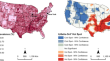
Analyzing spatial variations of heart disease and type-2 diabetes: A multi-scale geographically weighted regression approach
Heart disease is the leading cause of death in the United States. A person who has type-2 diabetes is twice as likely to have heart disease than...

-
Artificial Intelligence for the Automated Creation of Multi-scale Digital Twins of the Built World—AI4TWINNING
The AI4TWINNING project aims at the automated generation of a system of inter-related digital twins of the built environment spanning multiple...
-
MPM-Net: a Data-Driven Approach for Forecasting Indian Heatwave and Cold Wave Events Using Dehazing and Ensemble Learning Technique
This paper proposes a data-driven approach for forecasting Indian heatwave and cold wave events by dehazing high-resolution multispectral remote...

-
An Alternative Raw Data Acquisition Approach for Reconstruction of LOD3 Models
Visual, autonomous, object-based outdoor vehicle localization premise detailed object-based maps. Semantic-rich and qualitative Level of detail 3...
-
Multi-scale modelling for hydrodynamic and morphological changes of breakwater in coastal Mekong Delta in Vietnam
Coastal erosion has been occuring at a rapid rate in recent years along the Vietnamese Mekong coastline with particularly significant impacts...

-
Spatial evolution and growth mechanism of urban networks in western China: A multi-scale perspective
Globalization and informatization promote the evolution of urban spatial organization from a hierarchical structure mode to a network structure mode,...
-
Multi-scale coupling analysis of urbanization and ecosystem services supply-demand budget in the Bei**g-Tian**-Hebei region, China
Rapid economic development and human activities have severely affected ecosystem function. Analysis of the spatial distribution of areas of rapid...
-
Multi-scale analysis of trade-off/synergistic effects of forest ecosystem services in the Funiu Mountain Region, China
The trade-offs and synergies of forest ecosystem service are important research topics for several disciplines. The multi-scale analysis of service...
-
Multi-scale Inequality and Segregation: Theory and Estimation
This[aut]Johnston, Ron chapter[aut]Manley, David explores[aut]Owen, Gwilym multi-scaleMulti-scale estimation[aut]Song, Hui methods[aut]Wang, Bifeng...
-
Spatio-temporal Evaluation of Multi-scale Cultivated Land System Resilience in Black Soil Region from 2000 to 2019: A Case Study of Liaoning Province, Northeast China
It is of great significance to systematically analyze the cultivated land system resilience (CLSR) for the black soil protection and national food...
-
Using Geographically Weighted Models to Explore Obesity Prevalence Association with Air Temperature, Socioeconomic Factors, and Unhealthy Behavior in the USA
The literature informs assumptions about the relationship between obesity prevalence and socioeconomic and environmental factors. Little is known...
-
Towards an AI-driven framework for multi-scale urban flood resilience planning and design
Climate vulnerability is higher in coastal regions. Communities can largely reduce their hazard vulnerabilities and increase their social resilience...

-
Identification and Interpretation of Change Patterns in Semantic 3D City Models
Urban Digital Twins have received significant attention in recent years due to their economic and research importance. Although many definitions...
-
GIS Data Models
This chapter is concerned with the understanding of the raster and the vector data models of GIS and their data structure. After reading this...
-
Develo** Maize Yield Predictive Models from Sentinel-2 MSI Derived Vegetation Indices: An Approach to an Early Warning System on Yield Fluctuation and Food Security
Annual crop yield fluctuation due to natural and anthropogenic factors is a major concern of the Ethiopian Government. For an immediate response to...

-
Assessment of desertification hazard using RS and GIS to compare the efficiency of FAO-UNEP and MEDALUS models
This study aimed to compare the effectiveness of FAO-UNEP and MEDALUS models in evaluating desertification risk in the south of Nishabur, located in...
-
Reconstructing Façade Details Using MLS Point Clouds and Bag-of-Words Approach
In the reconstruction of façade elements, the identification of specific object types remains challenging and is often circumvented by rectangularity...
-
Singapore: An Integrated Multi-scale Urban Microclimate Model for Urban Planning in Singapore
The urban heat island (UHI) is one of the most critical issues for dense urban environments, as high outdoor temperatures and poor wind flow in...
-
Nonstationary Flood Frequency Analysis: Review of Methods and Models
Recent changes in the climate, land use/land cover, and field-scale water resources allocation at the catchment scale have rendered the conventional...