Search
Search Results
-
LFEA-Net: semantic segmentation for urban point cloud scene via local feature extraction and aggregation
Considering the increasing prominence of 3D real city construction technology, 3D urban point cloud scene data merit further investigation. However,...

-
Automatic urban feature extraction using rule-based object-oriented classification: a case study of parts of Pune city, Maharashtra, India
Urban areas are gaining attention globally with the implementation of the United Nations sustainable development agenda 2030 where more emphasis is...

-
Change Detection and Feature Extraction Using High-Resolution Remote Sensing Images
Change detection using high temporal resolution remote sensing satellite data for identifying changes on the Earth’s surface is critical in urban...

-
Analysis of Texture Feature Extraction Technique in Image Processing
Texture feature is one of the most common image segmentation, classification, extraction, and surface analysis techniques. In many image processing...
-
Hyperspectral dimensionality reduction based on SAE-1DCNN feature selection approach
Hyperspectral remote sensing enables a detailed spectral description of the object’s surface, but it also introduces high redundancy because the...

-
Hybrid Behrens-Fisher- and Gray Contrast–Based Feature Point Selection for Building Detection from Satellite Images
Over the past few years, satellite images have been one of the most influential and paramount tools utilized by meteorologists since these images...

-
A prior knowledge guided deep learning method for building extraction from high-resolution remote sensing images
There are problems such as poor interpretability and insufficient generalization ability when extracting buildings from high-resolution remote...

-
Geologic Feature Extraction from Remote Sensing Data
In this section we will use remote sensing data to extract structural, depositional and erosional features from digital relief models and satellite...
-
Automatic Landform Recognition, Extraction, and Classification using Kernel Pattern Modeling
Detection of terrain features more quickly and accurately is crucial in geosciences for the extracting and classifying landforms. Part of the local...

-
A semi-automatic method for extraction of urban features by integrating aerial images and LIDAR data and comparing its performance in areas with different feature structures (case study: comparison of the method performance in Isfahan and Toronto)
In this article, a new feature detection approach based on integration of LiDAR data and visible images in the form of a semi-automatic method has...

-
A critical analysis of road network extraction using remote sensing images with deep learning
The Extraction of Roads from Remote Sensing Imagery is a rapidly develo** field that has significant impacts on both the economic and social...
-
Develo** approaches in building classification and extraction with synergy of YOLOV8 and SAM models
The ability to extract meaningful information from visual material, such as photographs and videos, has significantly enhanced the potential for...

-
Ultra-resolution unmanned aerial vehicle (UAV) and digital surface model (DSM) data-based automatic extraction of urban features using object-based image analysis approach in Gurugram, Haryana
Unmanned aerial vehicles (UAV) have emerged as flexible, swift, and economical imaging systems that have proven their feasibility in urban...

-
A Holistic Workflow for Semi-automated Object Extraction from Large-Scale Historical Maps
The extraction of objects from large-scale historical maps has been examined in several studies. With the aim to research urban changes over time,...

-
Aspect in Topography to Enhance Fine-detailed Landform Element Extraction on High-resolution DEM
The value of the high-resolution data lies in the high-precision information discovery. The fine-detailed landform element extraction is thus the...
-
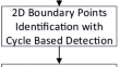
3D Cadaster Creation from Generalized Blueprint Based on Semantic Boundary Point Extraction
3D cadaster is essential for city management along with the construction of skyscrapers and underground infrastructures. Traditionally, the boundary...
-
Survey of Road Extraction Methods in Remote Sensing Images Based on Deep Learning
Road information plays a fundamental role in application fields such as map updating, traffic management, and road monitoring. Extracting road...

-
Evaluation of Feature Selection and Feature Extraction Techniques on Multi-Temporal Landsat-8 Images for Crop Classification
Recent advancements in the remotely sensed data products and machine learning algorithms are utilized effectively for classification of crops over a...

-
Comparing Sensors for Feature Extraction
The extraction of features from coarse resolution satellite imagery is reliable for regional scale of the area, primarily, and applicable to a...
-
Semi-automatic extraction of land degradation processes using multi sensor data by applying object based classification technique
A semi-automated method has been developed for the extraction of land degradation processes using multi sensor data by applying an object-based...
