Search
Search Results
-
Processing CORONA image for generation of Digital Elevation Model (DEM) and orthophoto of Bilaspur district, Himachal Pradesh
Declassified CORONA images provide stereo pairs that could be used for preparation of Digital Elevation Models (DEMs) and orthophotos that could be...

-
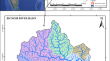
Inter-comparison and assessment of digital elevation models for hydrological applications in the Upper Mahi River Basin
This study evaluates and compares the accuracy and reliability of multiple freely available digital elevation models (DEMs) including Copernicus...

-
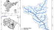
Morphometric analysis of Bichom River basin, Arunachal Pradesh, India using ALOS PALSAR RTC DEM and geospatial technology
Morphometric analysis provides an essential understanding of the geo-hydrological nature of a drainage basin. The advancements in remote sensing...
-
Comparison and Validation of Elevation Data at Selected Ground Control Points and Terrain Derivatives Derived from Different Digital Elevation Models
Digital elevation model (DEM) is a precisely defined 3D representation of terrain surface. DEM from satellite imageries have grown in popularity over...

-
Evaluation of vertical accuracy of different digital elevation models sources for Buraydah city
Digital Elevation Models (DEMs) are used in a variety of applications and in different scientific disciplines. Analysis of the DEM datasets for these...

-
Accuracy Assessment of Different Open-Source Digital Elevation Model Through Morphometric Analysis for a Semi-arid River Basin in the Western Part of India
Accurate watershed delineation and drainage system extraction are critical aspects for the hydrological and geomorphological models. However,...

-
Visual and statistical comparison of ASTER, SRTM, and Cartosat digital elevation models for watershed
Accurate delineation of watershed and drainage networks is crucial for hydrological and geomorphological models, water resource management, change of...

-
A study on historical location and evolution of Lop Nor in China with maps and DEM
Lop Sea, located at the east end of the Tarim Basin, Northwest China, dried up permanently, which is the terminal lake of the Tarim River. Lop Sea...
-
Quantitative morphometric analysis of Veshav and Rembi Ara watersheds, India, using quantum GIS
Quantitative drainage morphometric analysis has assumed tremendous significance as it plays an important role in understanding the hydrological...

-
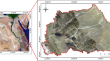
An approach to extracting digital elevation model for undulating and hilly terrain using de-noised stereo images of Cartosat-1 sensor
A digital elevation model (DEM) is established as an essential geospatial dataset requisite for many topographical and environmental applications....

-
Morphometric Analysis of Panzara River Basin Watershed, Maharashtra, India Using Geospatial Approach
This work aims to deal with the morphometric analysis of the Panzara River Basin (PRB) watershed, a tributary of the Tapi River in Maharashtra,...
-
Characterizing the behavior of surge-type glaciers in the Puruogangri Ice Field, Tibetan Plateau
The Puruogangri Ice Field (PIF), classified as an ultra-continental glacier, is considered extremely stable. However, several glaciers in this area...
-
Assessing the accuracy of open-source digital elevation models for the geomorphological analysis of very small islands of Indonesia
Digital elevation models (DEMs) are used for many geosciences studies; hence, their accuracy is essential. Throughout the world, there are many small...

-
Spatio-temporal variability of monsoon precipitation and their effect on precipitation triggered landslides in relation to relief in Himalayas
Orography of Himalaya governs the regional weather system and monsoon of Indian sub-continent. The intense persistent precipitation in the form of...

-
Insights into the morphometric characteristics of the Himalayan River using remote sensing and GIS techniques: a case study of Saryu basin, Uttarakhand, India
The watershed’s hydrological response behavior can be elucidated by studying its various morphometric parameters with geographic information system...
-
Flash flooding hazard assessment, modeling, and management in the coastal zone of Ras Ghareb City, Gulf of Suez, Egypt
The assessment of flash flood hazards in the coastal zone of Ras Ghareb City (RGC), Red Sea, Egypt, was accomplished through the use of GIS tools and...
-
Positional accuracy assessment of historical Google Earth imagery in Lagos State, Nigeria
The horizontal accuracy of historical Google Earth (GE) images at four epochs between the years 2000 and 2018, and the vertical accuracy of its...

-
Why are glacial lakes in the eastern Tianshan Mountains expanding at an accelerated rate?
Monitoring alpine lakes is important for understanding the regional environmental changes caused by global warming. In this study, we provided a...
-
Glacier mass balance in High Mountain Asia inferred from a GRACE release-6 gravity solution for the period 2002–2016
We provide estimates of glacier mass changes in the High Mountain Asia (HMA) area from April 2002 to August 2016 by employing a new version of...
-
Geoinformatics and Analytic Hierarchy Process (AHP) in modelling groundwater potential in Obudu Plateau, Southeastern Nigeria Bamenda Massif
Water is a vital resource used in effective sanitation, hygiene, drinking and agricultural uses. This study was in Obudu Plateau covering an area of...
