Search
Search Results
-
Spatio-temporal variation of aerosol loading and planetary boundary layer height before, during and after COVID-19 lockdown over the major cities in India
COVID-19 led to an unprecedented reduction in anthropogenic emissions due to the shutdown of worldwide economic and transportation activities. This...

-
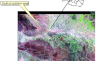
Automated floodwater depth estimation using large multimodal model for rapid flood map**
Information on the depth of floodwater is crucial for rapid map** of areas affected by floods. However, previous approaches for estimating...

-
Assessment of desertification hazard using RS and GIS to compare the efficiency of FAO-UNEP and MEDALUS models
This study aimed to compare the effectiveness of FAO-UNEP and MEDALUS models in evaluating desertification risk in the south of Nishabur, located in...
-
A bibliometric analysis for Indian summer monsoon variability
The study of monsoon variability in India has been the focus of scientific research for many decades due to its impact on agricultural production and...

-
Graph attention networks unveil determinants of intra- and inter-city health disparity
Understanding the determinants underlying variations in urban health status is important for informing urban design and planning, as well as public...

-
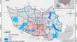
Enhancing Flood Risk Analysis in Harris County: Integrating Flood Susceptibility and Social Vulnerability Map**
Due to climate change, the frequency and intensity of floods have dramatically increased worldwide. The innate social inequality has been exposed and...
-
Combining Spatial Downscaling Techniques and Diurnal Temperature Cycle Modelling to Estimate Diurnal Patterns of Land Surface Temperature at Field Scale
Land surface Temperature (LST) at high spatial resolution and at sub-daily scale is highly useful for monitoring evaporative stress in plants,...

-
Exploring the Potential of Thermal Remote Sensing for Marine Freshwater Springs Identification in the United Arab Emirates
The initial objective of this research is to understand if thermal remote sensing is a viable source to detect or identify submarine freshwater in...

-
Bundle Adjustment of Aerial Linear Pushbroom Hyperspectral Images with Sub-Pixel Accuracy
Linear pushbroom (LP) cameras are often used in airborne hyperspectral imaging (HSI). Orthoimages are generated for HSI analyses but these require...

-
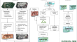
Digital twins in urban informatics
Urban informatics appears to be a suitable area for the application of digital twins. Definitions of the term share some characteristics, but these...
-
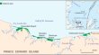
Assessing the impact of hurricane Fiona on the coast of PEI National Park and implications for the effectiveness of beach-dune management policies
The impact of waves, storm surge, and aeolian transport associated with Post-tropical Storm Fiona (offshore significant wave height ∽ 8 m, storm...
-
MANGLEE: A Tool for Map** and Monitoring MANgrove Ecosystem on Google Earth Engine—A Case Study in Ecuador
Mangroves, integral to ecological balance and socioeconomic well-being, are facing a concerning decline worldwide. Remote sensing is essential for...
-
Image Processing of Landsat-8 OLI Satellite Data for Map** of Alkaline-Carbonatite Complex, Southern India
The alkaline-carbonatite igneous intrusion occupies a very less aerial extent on the earth’s surface. However, it is an important source rock for...

-
Spatial scaling effects of gully erosion in response to driving factors in southern China
Gully erosion, an integrated result of various social and environmental factors, is a severe problem for sustainable development and ecology security...
-
A 1000-year history of cropland cover change along the middle and lower reaches of the Yellow River in China
Landscape in the middle and lower reaches of the Yellow River in China has undergone significant changes for thousands of years due to agricultural...
-
Analysis of Air Pollution from Vehicle Emissions for the Contiguous United States
Road transport remains a significant contributor to air pollution, particularly in the form of nitrogen oxides (NO x ). Using multiple data sources to...

-
Understanding coordinated development through spatial structure and network robustness: A case study of the Bei**g-Tian**-Hebei region
In the context of accelerated globalization, intercity factor flows are becoming increasingly dependent on a reasonable and orderly spatial...
-
The coupling coordination of social and economic upgrading in China: Evolution, regional disparities and influencing factors
Social upgrading does not inherently follow economic upgrading; rather, they present a complex interplay. This paper, focusing on China, utilizes the...