Search
Search Results
-
Temporal trend evaluation in monitoring programs with high spatial resolution and low temporal resolution using geographically weighted regression models
Data from monitoring programs with high spatial resolution but low temporal resolution are often overlooked when assessing temporal trends, as the...

-
Refinement analysis of landslide risk assessment for wide area based on UAV-acquired high spatial resolution images
The Loess Plateau is the largest loess accumulation zone globally. It has a fragile geological and ecological environment, experiences significant...

-
Improving SMAP soil moisture spatial resolution in different climatic conditions using remote sensing data
Soil moisture (SM) at the interface between the land surface and atmosphere is one of the major environmental parameters which plays an important...

-
Spatial model for daily air quality high resolution estimation
In air quality modeling, fine-scale daily map** is generally calculated from dispersion models involving multiple parameters linked in particular...

-
Land cover and crop types map** using different spatial resolution imagery in a Mediterranean irrigated area
Crop type identification is critical for agricultural sustainability policy development and environmental assessments. Therefore, it is important to...

-
Does spatial resolution matter in the estimation of average annual soil loss by using RUSLE?—a study of the Urmodi River Watershed (Maharashtra), India
The study investigates the influence of multispectral satellite data’s spatial resolution on land degradation in the Urmodi River Watershed in which...
-
Assessment of fire resilience in subtropical wetlands using high spatial resolution images
Resilience is the ability of a system to absorb disturbances, rearrange itself, and adapt in order to maintain its functionality, structure,...

-
High spatial resolution assessment of air quality in urban centres using lichen carbon, nitrogen and sulfur contents and stable-isotope-ratio signatures
Air pollution and poor air quality is impacting human health globally and is a major cause of respiratory and cardiovascular disease and damage to...

-
Iranian wetland inventory map at a spatial resolution of 10 m using Sentinel-1 and Sentinel-2 data on the Google Earth Engine cloud computing platform
Detailed wetland inventories and information about the spatial arrangement and the extent of wetland types across the Earth’s surface are crucially...

-
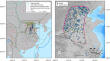
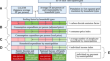
Multi-hazard susceptibility model based on high spatial resolution data—a case study of Sali settlement (Dugi otok, Croatia)
The world has been facing an increase in various natural hazards. The coastal regions are recognized as one of the most vulnerable due to high...

-
Assessment of high spatial resolution satellite imagery for monitoring riparian vegetation: riverine management in the smallholding
Riverine habitats are essential ecotones that bridge aquatic and terrestrial ecosystems, providing multiple ecosystem services. This study analyses...

-
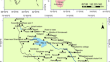
A high-resolution time-variable terrestrial gravity field model of continental North China
Given the spatial resolution of ~300 km in Gravity Recovery and Climate Experiment (GRACE) measurements, accurately quantifying mass variations at...
-
Input data resolution affects the conservation prioritization outcome of spatially sparse biodiversity features
Detailed spatial data are an essential part of land use planning and decision-making. Their spatial resolution sets limitations to their use, as...

-
Method for monitoring environmental flows with high spatial and temporal resolution satellite data
Monitoring environmental flows is crucial to maintaining the function and stability of river and lake ecosystems. However, current methods for...

-
A general approach for evaluating of the coverage, resolution, and representation of streamflow monitoring networks
Streamflow monitoring networks provide information for a wide range of public interests in river and streams. A general approach to evaluate...

-
Development of urban air monitoring with high spatial resolution using mobile vehicle sensors
Traditionally, the equipment used to measure air pollution is expensive and placed around cities or in mobile laboratories. It might only represent a...

-
On the effects of spatial resolution on effective distance measurement in digital landscapes
BackgroundConnectivity is an important landscape attribute in ecological studies and conservation practices and is often expressed in terms of...

-
Combining spatial autocorrelation with artificial intelligence models to estimate spatial distribution and risks of heavy metal pollution in agricultural soils
Information on spatial distribution and potential sources of heavy metals in agricultural lands is very important for human health and food safety....

-
Development of a method for downscaling ecological footprint and biocapacity to a 1-km square resolution
In this study, we propose a method for downscaling ecological footprint (EF) and biocapacity (BC) to a 1-km square resolution for a spatially...
-
A perspective on biodiversity data and applications for spatio-temporally robust spatial planning for area-based conservation
The growing availability of high-resolution biodiversity data is enhancing our ability to implement biodiversity conservation more effectively....
