Search
Search Results
-
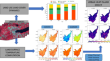
Enhanced COVID-19 Classification Using Ensemble Meta-Algorithms on Chest X-ray Images
Ensemble learning is a commonly used approach in machine learning where multiple learners are trained and merged to solve the same problem. The main...
-
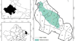
Land subsidence susceptibility map**: a new approach to improve decision stump classification (DSC) performance and combine it with four machine learning algorithms
Land subsidence is a worldwide threat. In arid and semiarid lands, groundwater depletion is the main factor that induce the subsidence resulting in...

-
Deep learning system for paddy plant disease detection and classification
Automatic detection and analysis of rice crop diseases is widely required in the farming industry, which can be utilized to avoid squandering...

-
Vegetation type and land cover map** in a semi-arid heterogeneous forested wetland of India: comparing image classification algorithms
The present study evaluates and compares performance of three supervised classification algorithms namely Maximum Likelihood (MXL), Artificial Neural...
-
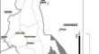
Monitoring Wetlands in Southern Iraq Based on Landsat Data
The wetlands in southern Iraq, known as the Mesopotamian Marshes, are an important element of the continental ecosystem that requires a simple and...
-
Supervised cross-fusion method: a new triplet approach to fuse thermal, radar, and optical satellite data for land use classification
This study presents a new fusion method namely supervised cross-fusion method to improve the capability of fused thermal, radar, and optical images...

-
Assessment of urban air quality from Twitter communication using self-attention network and a multilayer classification model
Social media platforms are one of the prominent new-age methods used by public for spreading awareness or drawing attention on an issue or concern....

-
Deep learning-based burned forest areas map** via Sentinel-2 imagery: a comparative study
In order to evaluate the effects of forest fires on the dynamics of the function and structure of ecosystems, it is necessary to determine burned...

-
Prioritization of key indicators for the classification of successional stages in regenerating subtropical Atlantic forest, Southern Brazil: a proposal based on multivariate order statistics
Statement of problem . Brazilian guidelines establish a set of parameters to classify forest regeneration stages, but there are no criteria or...

-
Urban Environments
Urbanization has dramatically changed Earth’s surface. This chapter starts with a qualitative look at the impact urban expansion has on the...
-
A hierarchical analysis of ecosystem classification with implementing in two continental ecoregions
BackgroundThe ecosystem classification of land (ECL) has been studied for a couple of decades, from the beginning of the perfect organism system...

-
Monitoring and simulating landscape changes: how do long-term changes in land use and long-term average climate affect regional biophysical conditions in southern Malawi?
We set out to reveal the effects of long-term changes in land use and long-term average climate on the regional biophysical environment in southern...
-
Improving the Performance of Classification Algorithms with Supervised Filter Discretization Using WEKA on NSL-KDD Dataset
Naive Bayes and Bayes net are critical classification method for data mining and have built up important software tools for the classification,...
-
A Canberra distance-based complex network classification framework using lumped catchment characteristics
Hydrological prediction in ungauged catchments remains a challenge despite numerous attempts in the past. The well-known solution to this challenge...

-
Multi-decadal coastal change detection using remote sensing: the Mediterranean coast of Egypt between El-Dabaa and Ras El-Hekma
A key source of information for many decision support systems is identifying land use and land cover (LULC) based on remote sensing data. Land...

-
Long-term monitoring of forest cover change resulting in forest loss in the capital of Luang Prabang province, Lao PDR
Loss of forest cover has an important impact on global climate change. This study investigated variation in forest cover in Luang Prabang district,...

-
Assessing the spatial variation of crop** intensity using multi-temporal Sentinel-2 data by rule-based classification
The present study was conducted to analyze crop** intensity of four blocks (Mogra-Chinsurah, Polba-Dadpur, Singur and Haripal) of the Gangetic...

-
Assessment of land-use land-cover dynamics and urban heat island effect of Dehradun city, North India: a remote sensing approach
Urbanisation is a crucial issue for urban planners and researchers worldwide, especially in South Asia, where rapid urbanisation has led to several...
-
Land cover and crop types map** using different spatial resolution imagery in a Mediterranean irrigated area
Crop type identification is critical for agricultural sustainability policy development and environmental assessments. Therefore, it is important to...

-
LULC change detection using support vector machines and cellular automata-based ANN models in Guna Tana watershed of Abay basin, Ethiopia
Recurrent changes recorded in LULC in Guna Tana watershed are a long-standing problem due to the increase in urbanization and agricultural lands....
