Search
Search Results
-
Influence of Path Illumination on the Amplitude Characteristics of VLF Signals
AbstractThe influence of path illumination on the amplitude of ultralong-wave radio signals during the passage of the solar terminator is discussed....

-
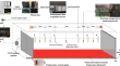
Exploring Acoustic Wave Propagation and Equivalent Path in Quasi-Porous Medium of Loose Coal Mass
In acoustic temperature measurement, precise determination of sound propagation characteristics is critical for calculating sound propagation...
-
Earth’s Ionosphere and Electromagnetic Signal Propagation
This chapter provides a comprehensive overview of the Earth’s ionosphere and its influence on electromagnetic signal propagation, particularly...
-
Retrieval of Cloud Liquid Water Path from MSU-GS Data Onboard Arktika-M 1
AbstractThis paper presents a method for cloud water path retrieval from daytime MSU-GS measurements onboard the Russian hydrometeorological...

-
Excavation Stress Path Induced Fracturing Mechanism of Hard Rock in Deep Tunnel
Excavation of deep hard rock tunnels disturbs the initial stress imbalance, which can lead to rockburst, spalling and/or collapse. The disasters are...

-
Seasonal velocity variations over the entire Kuroshio path part II: dynamical interpretation for the current speed variation
The response of a jet to sudden winds was examined using a simple numerical regional model and an analytical model to investigate the mechanism...

-
Earthquake prediction assessment using VLF radio signal sounding and space-based ULF emission observation
The present paper aims at earthquake prediction assessment in Iran using VLF radio signal sounding and space-based ULF emission observation. VLF...

-
Satellite visibility analysis considering signal attenuation by trees using airborne laser scanning point cloud
The number of visible global navigation satellite system (GNSS) satellites is an important indicator for evaluating positioning accuracy. In urban...

-
A path analysis approach to model the gross primary productivity of mangroves using climate data and optical indices
The present study targets modeling the mangrove’s gross primary productivity (GPP) through path analysis using Sentinel-2 satellite-derived optical...

-
Sequential GNSS-Acoustic seafloor point positioning with modeling of sound speed variation
Seafloor real-time positioning is important for the instantaneous detection of seafloor crustal motion, seismic activities, hydrological rapid...

-
“Novel 2019 Coronavirus Outbreak” through the Eyes of GNSS Signal
Besides the global crisis of the novel COVID-19 outbreak, we have presented the other side towards an environmental perspective. Due to the economic...
-
Multidecadal variation of the Earth’s inner-core rotation
Differential rotation of Earth’s inner core relative to the mantle is thought to occur under the effects of the geodynamo on core dynamics and...

-
Evolution of the Atmospheric Pressure Signal from the Tonga Volcano with Distance from It
AbstractA model of propagation of an atmospheric pressure signal from the eruption of the Hunga Tonga−Hunga Haʻapai volcano is proposed. This model...

-
GNSS signal ray-tracing algorithm for the simulation of satellite-to-satellite excess phase in the neutral atmosphere
Traditionally, GNSS space-based and ground-based estimates of tropospheric conditions are performed separately. It leads to limitations in the...

-
Study on the Law of Failure Acoustic–Thermal Signal of Weakly Cemented Fractured Rock with Different Dip Angles
The diagenetic environment and geological conditions in the west are special, and weakly cemented rocks with low strength, poor cementation and...

-
Snow depth retrieval using GPS signal-to-noise ratio data based on improved complete ensemble empirical mode decomposition
Snow is essential to the Earth's water source and plays a significant role in studying the climate system and hydrological cycle. Snow depth...

-
Analysis of signal-to-noise ratio retrieved from multi-GNSS satellite data of land surface reflections
The reflection of Global Navigation Satellite System (GNSS) signals, known as GNSS reflectometry (GNSS-R), has made significant progress in...

-
Temporal-spatial oceanic variation in relation with the three typical Kuroshio paths south of Japan
Empirical orthogonal function (EOF) analysis was applied to a 50-year long time series of monthly mean positions of the Kuroshio path south of Japan...
-
A stochastic model for precise GNSS/acoustic underwater positioning based on transmission loss of signal intensity
Global navigation satellite system (GNSS)/acoustic (GNSS/A) underwater positioning technique is widely applied in the fields of marine scientific...

-
Source Characteristics and Path Attenuation for the Yangbi, China Seismic Sequence in 2021
On 21 May 2021, an M 6.4 earthquake occurred in Yangbi county, west of Yunnan Province, China. The Yangbi seismic sequence was initiated on 18 May...
