Search
Search Results
-
MIRS: an imaging spectrometer for the MMX mission
The MMX infrared spectrometer (MIRS) is an imaging spectrometer onboard MMX JAXA mission. MMX (Martian Moon eXploration) is scheduled to be launched...

-
Discrete aurora and the nightside ionosphere of Mars: an EMM–MEX conjunction of FUV imaging, ionospheric radar sounding, and suprathermal electron measurements
Since 2021, a new surge in discrete aurora detections at Mars has been observed by the Emirates Mars Ultraviolet Spectrometer (EMUS) onboard the...

-
In situ science on Phobos with the Raman spectrometer for MMX (RAX): preliminary design and feasibility of Raman measurements
Mineralogy is the key to understanding the origin of Phobos and its position in the evolution of the Solar System. In situ Raman spectroscopy on...

-
Hyperspectral imaging for mineral composition and weathering recognition of rock slope on the reservoir bank
The mineral composition and weathering degree of the hydro-fluctuation belt are affected by water–rock interaction. However, traditional methods for...

-
Enhancing remote target classification in hyperspectral imaging using graph attention neural network
AbstractThe method of target classification known as hyperspectral imaging (HSI) is commonly used in the field of remote sensing. However, recent...

-
Fast CO2 Retrieval Using a Semi-Physical Statistical Model for the High-Resolution Spectrometer on the Fengyun-3D Satellite
China’s Fengyun-3D meteorological satellite launched in December 2016 carries the high-resolution greenhouse-gases absorption spectrometer (GAS)...
-
The contribution of VNIR and SWIR hyperspectral imaging to rock art studies: example of the Otello schematic rock art site (Saint-Rémy-de-Provence, Bouches-du-Rhône, France)
This paper presents a methodological contribution to rock art archaeology by demonstrating the benefits of hyperspectral imaging, a relatively new...

-
Grou** Small Spacecraft for Global Meteorological Observations Using a Microwave Radiometer–Spectrometer
AbstractThe current state of microwave radiometry for remote sensing of the Earth is considered. There are currently some 30 satellite microwave...

-
Imaging Techniques
This chapter introduces techniques for characterizing the properties of the Earth's surface and atmosphere using satellite sensors. The utilization...
-
Geographical and seasonal variations of gravity wave activities in the upper mesosphere measured by space-borne imaging of molecular oxygen nightglow
Geographical and seasonal variations of gravity wave events in the upper mesosphere were investigated using the nightglow imaging data obtained by...

-
Integration of Neutron-Based Elemental Analysis and Imaging to Characterize Complex Cultural Heritage Objects
Prompt-gamma activation analysis (PGAA), a nondestructive, neutron-based bulk elemental analysis method, has been actively used for more than...
-
Single-particle Mineralogy of Asbestos Mineral Particles by the Combined Use of Low-Z Particle EPMA and ATR-FTIR Imaging Techniques
In this work, two single particle analytical techniques such as a quantitative energy-dispersive electron probe X-ray microanalysis (ED-EPMA), called...
-
A new analytical mode and application of the laser ablation inductively coupled plasma mass spectrometer in the earth sciences
We proposed a new laser analytical mode, which used the high-frequency laser ablation to deliberately obtain the peak-shape signal profile, combined...
-
Mid-infrared imaging spectroscopic measurements of C2H4 frost simulating the outer solar system environments
In the dense and cold atmosphere of Titan, the presence of C 2 H 4 haze has been confirmed by the observations of spacecraft. In the present study,...

-
Python-Based Open-Source Tool for Automating Seleno-Referencing of Chandrayaan-2 Hyper-Spectral Data Cubes
ISRO’s Imaging InfraRed Spectrometer (IIRS) onboard Chandrayaan-2 is relatively the most advanced spectrometer in the lunar orbit till date. IIRS...

-
Remembering IRS-1C Imaging Payloads: A Giant Leap in Indian Space Imaging System Evolution
Indian Remote Sensing (IRS) programme started in 1970s and has grown very systematically in all aspects of sensors, data products and applications...

-
A Semi-Supervised Model for Fine-Grained Identification of Oil Emulsions on the Sea Surface Using Hyperspectral Imaging
After oil spills occur in the ocean, oil pollutants usually appear in the form of oil emulsions under the influence of hydrodynamics. Hyperspectral...

-
Shape Classification of Cloud Particles Recorded by the 2D-S Imaging Probe Using a Convolutional Neural Network
The airborne two-dimensional stereo (2D-S) optical array probe has been operating for more than 10 yr, accumulating a large amount of cloud particle...
-
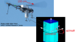
Inspection of a Restricted Access Site Using UAV Perimeter Survey with the ARDUO Direction-Capable Gamma Spectrometer
Under the comprehensive nuclear-test-ban treaty a State Party may request an on-site inspection to establish whether a nuclear explosion has taken...
-
Genetic Algorithm Framework for 3D Discrete Wavelet Transform based Hyperspectral Image Classification
Joint spatial–spectral feature extraction process is always playing a vital role in the accurate classification of hyperspectral imagery. Such...
