Search
Search Results
-
New South Wales and Southeastern Queensland
NSW contains approximately 90 cavernous karst environments ranging from relatively small outcrops with limited karstification to extensive areas with...
-
Two Decades of Glacier and Glacial Lake Change in the Dhauladhar Mountain Range, Himachal Himalayas, India (2000–2020)
This study represents a first of its kind effort in generating a comprehensive database of glaciers (74) and glacial lakes (43) in the Dhauladhar...

-
Large discrepancy between measured and remotely sensed snow water equivalent in the northern Europe and western Siberia during boreal winter
Accurate information on snowpack conditions is crucial for understanding changes in the hydrological cycle and its impacts on the climate system,...

-
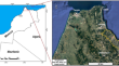
A ground instabilities inventory between Tetouan and Jebha (Morocco): map**, description and analysis
Ground instabilities inventories, regrou** the different existing instability typologies, are of primary importance for their comprehension and...
-
Magnetic field map of the Wilhelm Archipelago shelf zone, West Antarctica
The Antarctic Digital Magnetic Anomaly Project is an international research effort to construct a magnetic map of the continent based on ground,...

-
Structural and kinematic study of Ghuttu Window: Implication on the tectonic evolution of Bhilangana Formation, Central Crystalline Group, Garhwal Himalaya, India
AbstractGhuttu tectonic window is a structural window and is exposed around Ghuttu village in Bhilangana Valley, tectonically surrounded with...

-

-
Evaluation of Geotouristic Station Suitability Using GIS-Based Multi-criteria Decision Analysis: a Case Study of the M’Goun UNESCO Geopark, High Atlas (Morocco)
This study is part of a reflection process that aims to define and evaluate the most suitable places for the establishment of geotourism stations in...

-
Ice Movement
While the general movement patterns of glaciers were already described at the end of the nineteenth century, the three sub-processes that enable the...
-
Assessing geological hazard susceptibility and impacts of climate factors in the eastern Himalayan syntaxis region
The eastern Himalayan syntaxis (EHS) region is characterized by steep topography, strong tectonic activity, and strong disaster activity, and the...

-
Recreational value of glacier tourism resources: A travel cost analysis for Yulong Snow Mountain
Glaciers, with their unique and spectacular appearances and rich and varied terrain, have received widespread attention and become important tourist...
-
Geoheritage Merits of the Zanskar Range of the Kashmir Himalaya: a Field Geology Museum from Precambrian to Present
The Zanskar Range is unique in varied aspects and is always been an attraction to the geoscientists and tourists due to its geographic location. The...

-
Paleocene Glauconite of the Near-Volga Monocline of Submarine Volcanic Sedimentary Genesis
AbstractA new concept of the formation of glauconite from the Paleocene deposits of the sedimentary cover of the southwestern part of the Near-Volga...

-
Morphogenetic Features of Soils of the Svyatoi Nos Peninsula Coast (Eastern Cisbaikalia)
AbstractWe have studied soils of the western coast of the Chivyrkui and Barguzin bays on the Svyatoi Nos Peninsula, which is the largest peninsula of...

-
Fossil oceanic core complexes in the Alps. New field, geochemical and isotopic constraints from the Tethyan Aiguilles Rouges Ophiolite (Val d’Hérens, Western Alps, Switzerland)
Exhumation of basement rocks on the seafloor is a worldwide feature along passive continental margins and (ultra-) slow-spreading environments,...

-
Response of glaciers to future climate change in the Beida River catchment, northeast Tibetan Plateau
Understanding how future climate change impacts glaciers is crucial to sustainable water supplies and water resource managements. A calibrated...
-
Field Guide for a Complete Cross-Section of the Central Andes Along Main Roads
This guide presents seven itineraries to investigate the geology of the Central Andes, which can be done in seven days of field work along main roads...
-
The Geoheritage of Mount Olympus: Ancient Mythology and Modern Geology
Mount Olympos on the border of Thessaly and Central Macedonia (Greece) is the namesake of many mountains over the Earth and even on Mars. The...

-
Development and application of a spatially distributed snowmelt runoff model for limited data condition
Two main approaches are used to calculate snowmelt, namely, energy balance (physically based) and temperature index (conceptual). Energy balance...

-
Soil Formation on Sugar Industry Waste in the Central Chernozemic Zone
AbstractSoils formed in treatment facilities of sugar beet factories in the forest-steppe zone of Kursk oblast were studied. Technogenic factors of...
