Search
Search Results
-
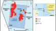
Progress and Challenges in Earth Observation Data Applications for Agriculture at Field Scale in India and Small Farm Holdings Regions
The paper traces the evolution of agricultural remote sensing in India through its four phases: initial exploratory and aerial data based...
-
Data Analysis and Exploration with Computational Approaches
Artificial intelligence and machine learning (ML) methods are increasingly applied in Earth system research, for improving data analysis, and model...
-
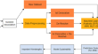
PODPAC: open-source Python software for enabling harmonized, plug-and-play processing of disparate earth observation data sets and seamless transition onto the serverless cloud by earth scientists
In this paper, we present the Pipeline for Observational Data Processing, Analysis, and Collaboration (PODPAC) software. PODPAC is an open-source...

-
Contrasting machine learning regression algorithms used for the estimation of permeability from well log data
The oil and gas industry has slowly shifted its focus to a more data science-driven interpretation approach from the last decade. The petrophysical...
-
A novel spatio-temporal trajectory data-driven development approach for autonomous vehicles
Nowadays, autonomous driving has been attracted widespread attention from academia and industry. As we all know, deep learning is effective and...
-
Hybrid mist-cloud systems for large scale geospatial big data analytics and processing: opportunities and challenges
The cloud and fog computing paradigms are develo** area for storing, processing, and analysis of geospatial big data. Latest trend is mist...

-
A Non-stationary NDVI Time Series with Big Data: A Deep Learning Approach
In this paper, a suitable method to forecast the normalized difference vegetation index (NDVI) time series (TS) is deep learning in the context of...
-
A data-driven analysis and optimization of the impact of prescribed fire programs on wildfire risk in different regions of the USA
In the current century, wildfires have shown an increasing trend, causing a huge amount of direct and indirect losses in society. Different methods...

-
Soil liquefaction in seismic events: pioneering predictive models using machine learning and advanced regression techniques
This study goes into the complex area of predicting soil liquefaction potential, a crucial issue in geotechnical engineering. The work presents a...

-
Utilizing Geo-Social Media as a Proxy Data for Enhanced Flood Monitoring
Social media plays an important role in disseminating spontaneous information during natural disasters/emergencies. It is a crowdsourcing platform,...

-
Mallestigite, Pb3Sb(SO4)(AsO4)(OH)6·3H2O, from the type locality – new data, crystal structure, and structural relationships
A report of the supergene mineral mallestigite, Pb 3 Sb 5+ (SO 4 )(AsO 4 )(OH) 6 ·3H 2 O, from the type locality Neufinkenstein-Grabanz district, Mallestiger...

-
OpenAltimetry - rapid analysis and visualization of Spaceborne altimeter data
NASA’s Ice, Cloud, and land Elevation Satellite-2 (ICESat-2) carries a laser altimeter that fires 10,000 pulses per second towards Earth and records...

-
The Use of Modern Physical Methods of Instrumental Analytics in the Study of Stromatolites
AbstractThe use of X-ray microtomography, neutron tomography, scanning electron microscopy and X‑ray microanalysis in the study of stromatolites is...

-
Data-Driven Science for Geosciences
Recent development of data-driven sciences gives a wide applicability for basic and applied sciences for natural phenomena with and without known...
-
Alarming Realities of Groundwater Dynamics in Basaltic Region through RS, GIS-Based Retrieval of Historical Data
A concept of retrieving and monitoring groundwater dynamics was introduced via metrics derived using Remote Sensing (RS) and Geographic Information...
-
Estimation of nitrogen content in wheat from proximal hyperspectral data using machine learning and explainable artificial intelligence (XAI) approach
Nitrogen (N) is a primary macronutrient essential for plant structures and metabolic processes, and the deficiency of N leads to critical plant...
-
Elderly Behavioural Ergonomic Data for Smart Cities’ Design-User System
Displacement of elderly people from smart cities should not happen in the future. Instead, it is a necessity to create an assistive environment for...
-
GeoVisual Analytics
Visual Analytics hat das Ziel, leistungsfähige Werkzeuge für die Analyse und Interpretation von Daten bereitzustellen. Die Werkzeuge sollen die...
-
Leveraging Hazard, Exposure, and Social Vulnerability Data to Assess Flood Risk to Indigenous Communities in Canada
This study integrates novel data on 100-year flood hazard extents, exposure of residential properties, and place-based social vulnerability to...

-
Seasonal hydrological loading from GPS observed data across contiguous USA using integrated R and Hadoop-GIS framework
Hydrological water mass redistribution on the Earth’s surface causes elastic loading deformation. In this study, vertical crustal deformation is...
