Search
Search Results
-
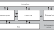
Develo** Strategies for Agricultural Water Management of Large Irrigation and Drainage Networks with Fuzzy MCDM
Sustainable water resources management aims at increasing the efficient use of water and achieving food security. This work proposes a generalized...

-
Map** mining waste and identification of acid mine drainage within an active mining area through sub-pixel analysis on OLI and Sentinel-2
The present research focuses on investigating the application of remote sensing for map** mining waste and identifying areas prone to acid mine...

-
Geomorphic Analysis of Baghain River, Yamuna Basin, and its Implication for Drainage Characteristic and Tectonics using Remote Sensing and GIS Techniques
The present study aims to access the geomorphic analysis of the Baghain river basin and its implication on landscape evolution. Baghain river...
-
An Approach for Determination of the Drainage Network Effect on GIUH Using Hesitant Probabilistic Fuzzy Linguistic Sets
Digital elevation models (DEMs) enable extraction of stream networks, delineation of watersheds and determination of geomorphological...

-
Numerical modeling of coal gas drainage in a three-dimensional framework
The underground coal mine is the largest source of methane generation in the mining sector. Methane is produced from underground and surface mines as...

-
Drainage Basin Shape Indices to Understanding Channel Hydraulics
Indices measuring drainage basin shape are of great significance because they not only measure forms (shape) of basins but provide quantitative...

-
Numerical and practical investigation of the multiple hole grouting repair law of underground drainage pipeline defects
The grouting sequence and spatial layout of grouting holes are key technical problems in the treatment of underground drainage pipeline defects. An...

-
Volcanic Island Drainage Divide Migration: Implications for Land Planning (Assomada Plateau, Santiago, Cape Verde)
Volcanic landscapes during island formation are due to lava flows and their accumulation processes. However, erosive processes dominate landscape...
-
Drainage evolution in intermontane basins at the Qinling-Daba Mountains
River capture is of great significance to landform evolution and hominine migration. In the Qinling-Daba Mountains, there is a viewpoint that Jialing...
-
Assessment of Influences of Anthropogenic and Climatic Changes in the Drainage Basin on Hydrological Processes in the Gulf of Ob
AbstractChanges in the runoff of rivers flowing into the Arctic Ocean caused by climate changes and increasing anthropogenic load lead to foreseeable...
-
A simple rule-based algorithm in Google Earth Engine for operational discrimination of rice paddies in Sefidroud Irrigation Network
To discriminate rice paddies in the Sefidroud Irrigation Network with minimal training data, we developed a Rule-based Rice Discriminate Algorithm...

-
Disaster Resilience Assessment for Drainage Network and Urban Landscape After Heavy Meteorological Events: Examples from the Middle Adriatic Coastal Area (Abruzzo Region, Central Italy)
Central Italy is sadly acknowledged as highly exposed to natural hazards and affected by ever-present disasters. The middle Adriatic coastal area of...
-
Suitability of the height above nearest drainage (HAND) model for flood inundation map** in data-scarce regions: a comparative analysis with hydrodynamic models
Unprecedented floods from extreme rainfall events worldwide emphasize the need for flood inundation map** for floodplain management and risk...

-
Towards Large-Scale DRP Simulations: Generation of Large Super-Resolution images and Extraction of Large Pore Network Models
AbstractRepresentativity and accuracy of digital rock physics (DRP) simulations depend strongly on the size of the image volume and the resolution...

-
Dedolomitization establishes flow pathways in Thalassinoides-bearing limestones: a quantitative case study using pore network model and flow simulation
The pore space of rocks acts as a storage for geofluids (oil, gas, water, CO 2 , contaminants, and metal-enriched solutions) and has been the target of...
-
Investigation of water productivity of wheat in some irrigation and drainage networks of Khuzestan
Crop water productivity is one of the indexes which are widely used in the issues related to crop productivity and water and is defined as the ratio...

-
Develo** a Model of the Morphological Pattern for Thermokarst Plains with Fluvial Erosion Involving Remote Sensing Data
AbstractThis paper reports a new variant of the model of the morphological pattern for thermokarst plains with fluvial erosion involving numerous...
-
The Hough transform algorithm coupled with spatial filtering for the study of geological structuring control on the drainage network: application to the North Oulmes region, Morocco
In a changing climate, the more we understand the drainage networks distribution and structuration, the more we can better predict flood risks, and...

-
Evolution of Alkaline Mine Drainage and Unique Biodiversity on Soil-Free Mine Substrates, Southern New Zealand
Relatively impermeable soil-free substrates (clay-rich outcrops and sediments) exposed at eight abandoned placer gold mines generate alkaline mine...

-
Characterization and Classification of River Network Types
In nature, rivers are always connected in various forms to constitute a specific type of river network. The identification and classification of...
